
Cumming Township is a civil township of Ogemaw County in the U.S. state of Michigan. The population was 796 at the 2000 census.

The Coal River is a tributary of the Kanawha River in southern West Virginia. It is formed near the community of Alum Creek by the confluence of the Big and Little Coal Rivers, and flows generally northward through western Kanawha County, past the community of Upper Falls and into the Kanawha River at St. Albans.

The Chippewa River is a stream in the U.S. state of Michigan that runs 91.8 miles (147.7 km) through the central Lower Peninsula. The Chippewa is a tributary of the Tittabawassee River and is thus part of the Saginaw River drainage basin. The river is named after the Chippewa people.

Wappinger Creek is a 41.7-mile-long (67.1 km) creek which runs from Thompson Pond to the Hudson River at New Hamburg in Dutchess County, New York, United States. It is the longest creek in Dutchess County, with the largest watershed in the county.
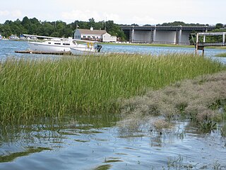
The Weymouth Back River, sometimes called Back River, is a short, primarily tidal river in Hingham and Weymouth, Massachusetts, about 10 miles (16 km) south of Boston. It arises from a number of tributaries in ponds and swamps, most notably Whitmans Pond, flows northward, and empties into Hingham Bay.

Thatcher Peninsula is a mountainous peninsula in north-central South Georgia. Its total area is approximately 5,640 hectares, with roughly 1,620 ha covered in vegetation. It erminates to the north in Mai Point, rising between Cumberland West Bay to the west, and Cumberland East Bay and Moraine Fjord to the east. It is bounded to the southwest and south by Lyell Glacier and Hamberg Glacier. King Edward Cove on the east side of the peninsula is the site of the British Antarctic Survey (BAS) Grytviken station and the disused whaling station of the same name.

The Sebasticook River is a 76-mile-long (122 km) river in the central part of Maine, in the United States. From its source in Dexter, the upper "Main Stream" section flows generally west and south 30 miles (48 km) to Great Moose Lake. From the outlet of the lake in Hartland, the Sebasticook flows 41 miles (66 km) south to the Kennebec River in Winslow.
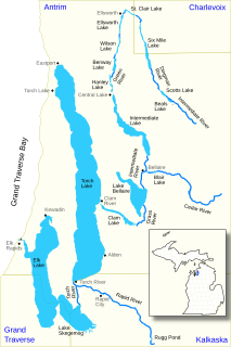
The Elk River Chain of Lakes Watershed is a 75-mile-long (121 km) waterway consisting of 14 lakes and connecting rivers in the northwestern section of the Lower Peninsula of the U.S. state of Michigan, which empty into Lake Michigan.

Poyntelle is a village in Preston Township, Wayne County, Pennsylvania, in the Lake Region of the Poconos. It was once a depot of the Scranton Division of the New York, Ontario & Western (O&W) Railway, but today, when it is known outside of its immediate vicinity, it is largely for being the location of Camps Westmont and Poyntelle Lewis Village, since the reputation and commercial reach of both, like those of most rural American summer camps, extend beyond the community in which the camps are physically located.
The Passadumkeag River is a river in Maine. From the confluence of its East Branch and West Branch in Maine Township 3, Range 1, NBPP, the river runs 48.2 miles (77.6 km) south and west to its mouth on the Penobscot River in Passadumkeag.
The Roach River is a river in Piscataquis County, Maine. From the outlet of Third Roach Pond in Shawtown, the river runs 19.1 miles (30.7 km) west, through a chain of ponds. The Flow sequence through the ponds is from the Fourth Roach Pond through the Third Roach Pond, Second Roach Pond, and First Roach Pond to empty into Moosehead Lake, the source of the Kennebec River, in Spencer Bay. The Seventh Roach Pond drains through the Sixth Roach Pond in a separate tributary to the Third Roach Pond. No fifth Roach Pond is shown on modern maps.
Little Carp River is a 15-mile-long (24 km) river in Gogebic and Ontonagon counties in the U.S. state of Michigan. The Carp River rises at 46°45′54″N89°44′44″W in the Porcupine Mountains of the Upper Peninsula.
Carp River is a 21.9-mile-long (35.2 km) river in Marquette County in the U.S. state of Michigan. The Carp River is formed by the outflow of Deer Lake in Ishpeming Township north of Ishpeming at 46°31′58″N87°40′01″W in the Upper Peninsula.

Range Ponds State Park is a public recreation area wrapping around the eastern end of Lower Range Pond in the town of Poland in Androscoggin County, Maine. The state park offers a sandy beach with lifeguard-supervised swimming, kayaking, limited motorized boating, hiking trails, and fishing. Mountain biking trails, built with the help of local volunteers, provide intermediate level, single-track loops off a central double-track trail that winds through mature pine and hardwood forests.

Boreas River is a river in Essex County and Hamilton County in the U.S. State of New York. Indian River begins at Boreas Ponds north-northeast of the Hamlet of Boreas River and flows southeastward before converging with the Hudson River southeast of Forks Mountain.

The Whiting River is a southward-flowing stream located in Massachusetts and the far northwest corner of Connecticut in the United States. The river runs for seven miles from its source at the Thousand Acre Swamp in New Marlborough before emptying into the Blackberry River in North Canaan. The river follows a curving southwesterly course for four miles in Massachusetts, passing over 100-foot-high Campbell Falls at Campbell Falls State Park Reserve, where it is joined by the northwest-flowing Ginger Creek. It flows south for 2.78 miles from the state line north of Canaan Valley to its mouth on the Blackberry River in Connecticut.

