Jackman, Maine | |
---|---|
Nickname: Switzerland Of Maine | |
Coordinates: 45°37′38″N70°12′39″W / 45.62722°N 70.21083°W | |
Country | United States |
State | Maine |
County | Somerset |
Incorporated | 1895 |
Area | |
• Total | 42.42 sq mi (109.87 km2) |
• Land | 41.26 sq mi (106.86 km2) |
• Water | 1.16 sq mi (3.00 km2) |
Elevation | 1,375 ft (419 m) |
Population (2020) | |
• Total | 783 |
• Density | 19/sq mi (7.3/km2) |
Time zone | UTC-5 (Eastern (EST)) |
• Summer (DST) | UTC-4 (EDT) |
ZIP code | 04945 |
Area code | 207 |
FIPS code | 23-35345 |
GNIS feature ID | 0582532 |
Website | jackmanmaine |
Jackman is a town in Somerset County, Maine, United States. The population was 783 at the 2020 census. [2]
According to the United States Census Bureau, the town has a total area of 42.42 square miles (109.87 km2), of which 41.26 square miles (106.86 km2) is land and 1.16 square miles (3.00 km2) is water. [1]
Jackman was named after Captain James Jackman, who was hired by the State of Maine in the 1830s to build the road connecting the United States with Canada. [3]
On April 8, 2024, Jackman was on the path of totality for a total eclipse of the sun. The eclipse was to sweep across most of the United States, but as the date approached, cloudy skies were forecast for most of that path. However, Jackman was expected to have clear skies that day, so the town of less than a thousand residents was inundated by more than 10,000 visitors from across the country. Officials said it was probably the largest crowd ever seen in Jackman. [4]
This climatic region is typified by large seasonal temperature differences, with only warm (but not hot) summers and cold (sometimes severely cold) winters. According to the Köppen Climate Classification system, Jackman has a humid continental or "hemiboreal" climate (due its lack of true summer heat), abbreviated "Dfb" (or sometimes "Dbf") on climate maps, as does all of Maine. [5]
Climate data for Jackman, Maine, 1991–2020 normals, extremes 1897–present | |||||||||||||
---|---|---|---|---|---|---|---|---|---|---|---|---|---|
Month | Jan | Feb | Mar | Apr | May | Jun | Jul | Aug | Sep | Oct | Nov | Dec | Year |
Record high °F (°C) | 58 (14) | 65 (18) | 75 (24) | 81 (27) | 97 (36) | 95 (35) | 102 (39) | 97 (36) | 92 (33) | 83 (28) | 73 (23) | 64 (18) | 102 (39) |
Mean maximum °F (°C) | 44.5 (6.9) | 46.3 (7.9) | 54.6 (12.6) | 68.4 (20.2) | 80.6 (27.0) | 86.4 (30.2) | 86.8 (30.4) | 85.7 (29.8) | 82.3 (27.9) | 72.3 (22.4) | 60.5 (15.8) | 48.3 (9.1) | 89.4 (31.9) |
Mean daily maximum °F (°C) | 22.4 (−5.3) | 25.7 (−3.5) | 35.3 (1.8) | 48.1 (8.9) | 63.0 (17.2) | 72.0 (22.2) | 76.5 (24.7) | 75.8 (24.3) | 68.6 (20.3) | 53.9 (12.2) | 40.8 (4.9) | 28.6 (−1.9) | 50.9 (10.5) |
Daily mean °F (°C) | 11.2 (−11.6) | 13.1 (−10.5) | 22.9 (−5.1) | 36.4 (2.4) | 50.0 (10.0) | 59.8 (15.4) | 64.8 (18.2) | 63.4 (17.4) | 55.6 (13.1) | 43.1 (6.2) | 31.5 (−0.3) | 19.1 (−7.2) | 39.2 (4.0) |
Mean daily minimum °F (°C) | 0.0 (−17.8) | 0.4 (−17.6) | 10.5 (−11.9) | 24.8 (−4.0) | 36.9 (2.7) | 47.5 (8.6) | 53.1 (11.7) | 50.9 (10.5) | 42.5 (5.8) | 32.4 (0.2) | 22.3 (−5.4) | 9.6 (−12.4) | 27.6 (−2.5) |
Mean minimum °F (°C) | −21.3 (−29.6) | −19.6 (−28.7) | −13.0 (−25.0) | 11.4 (−11.4) | 26.3 (−3.2) | 35.1 (1.7) | 42.5 (5.8) | 39.2 (4.0) | 29.9 (−1.2) | 20.7 (−6.3) | 4.8 (−15.1) | −12.2 (−24.6) | −24.9 (−31.6) |
Record low °F (°C) | −38 (−39) | −44 (−42) | −30 (−34) | −9 (−23) | 14 (−10) | 28 (−2) | 30 (−1) | 25 (−4) | 17 (−8) | 11 (−12) | −15 (−26) | −33 (−36) | −44 (−42) |
Average precipitation inches (mm) | 2.54 (65) | 2.31 (59) | 2.56 (65) | 3.25 (83) | 3.67 (93) | 4.64 (118) | 4.57 (116) | 4.00 (102) | 3.46 (88) | 4.28 (109) | 3.07 (78) | 3.42 (87) | 41.77 (1,063) |
Average snowfall inches (cm) | 21.5 (55) | 25.2 (64) | 19.4 (49) | 7.6 (19) | 0.2 (0.51) | 0.0 (0.0) | 0.0 (0.0) | 0.0 (0.0) | 0.0 (0.0) | 1.6 (4.1) | 7.2 (18) | 24.2 (61) | 106.9 (270.61) |
Average extreme snow depth inches (cm) | 21.8 (55) | 30.7 (78) | 30.6 (78) | 15.1 (38) | 0.2 (0.51) | 0.0 (0.0) | 0.0 (0.0) | 0.0 (0.0) | 0.0 (0.0) | 1.2 (3.0) | 5.2 (13) | 16.0 (41) | 36.5 (93) |
Average precipitation days (≥ 0.01 in) | 12.0 | 10.4 | 10.9 | 12.1 | 13.5 | 13.6 | 14.0 | 12.6 | 10.5 | 13.8 | 12.5 | 14.8 | 150.7 |
Average snowy days (≥ 0.1 in) | 8.2 | 8.2 | 6.8 | 2.7 | 0.2 | 0.0 | 0.0 | 0.0 | 0.0 | 0.8 | 3.9 | 9.3 | 40.1 |
Source 1: NOAA [6] | |||||||||||||
Source 2: National Weather Service [7] |
Census | Pop. | Note | %± |
---|---|---|---|
1840 | 10 | — | |
1850 | 12 | 20.0% | |
1870 | 65 | — | |
1880 | 95 | 46.2% | |
1890 | 217 | 128.4% | |
1900 | 352 | 62.2% | |
1910 | 667 | 89.5% | |
1920 | 902 | 35.2% | |
1930 | 1,099 | 21.8% | |
1940 | 1,069 | −2.7% | |
1950 | 964 | −9.8% | |
1960 | 984 | 2.1% | |
1970 | 848 | −13.8% | |
1980 | 1,003 | 18.3% | |
1990 | 920 | −8.3% | |
2000 | 718 | −22.0% | |
2010 | 862 | 20.1% | |
2020 | 783 | −9.2% | |
U.S. Decennial Census [8] |
As of the census [9] of 2010, there were 862 people, 383 households, and 228 families living in the town. The population density was 20.9 inhabitants per square mile (8.1/km2). There were 726 housing units at an average density of 17.6 per square mile (6.8/km2). The racial makeup of the town was 96.4% White, 0.1% African American, 1.0% Native American, 0.6% Asian, 0.1% from other races, and 1.7% from two or more races. Hispanic or Latino of any race were 1.7% of the population.
There were 383 households, of which 23.0% had children under the age of 18 living with them, 51.2% were married couples living together, 6.3% had a female householder with no husband present, 2.1% had a male householder with no wife present, and 40.5% were non-families. 32.1% of all households were made up of individuals, and 12% had someone living alone who was 65 years of age or older. The average household size was 2.19 and the average family size was 2.78.
The median age in the town was 44.8 years. 19.5% of residents were under the age of 18; 5.8% were between the ages of 18 and 24; 25.1% were from 25 to 44; 32.1% were from 45 to 64; and 17.5% were 65 years of age or older. The gender makeup of the town was 49.3% male and 50.7% female.
As of the census [10] of 2000, there were 718 people, 310 households, and 190 families living in the town. The population density was 17.5 inhabitants per square mile (6.8/km2). There were 585 housing units at an average density of 14.3 per square mile (5.5/km2). The racial makeup of the town was 98.75% White, 0.14% African American, 0.56% Native American, 0.56% from other races. Hispanic or Latino of any race were 1.81% of the population.
There were 310 households, out of which 33.5% had children under the age of 18 living with them, 46.8% were married couples living together, 9.4% had a female householder with no husband present, and 38.4% were non-families. 31.9% of all households were made up of individuals, and 15.5% had someone living alone who was 65 years of age or older. The average household size was 2.25 and the average family size was 2.84.
In the town, the population was spread out, with 25.8% under the age of 18, 5.3% from 18 to 24, 29.2% from 25 to 44, 25.1% from 45 to 64, and 14.6% who were 65 years of age or older. The median age was 40 years. For every 100 females, there were 96.2 males. For every 100 females age 18 and over, there were 92.4 males.
The median income for a household in the town was $29,615, and the median income for a family was $33,182. Males had a median income of $29,135 versus $21,310 for females. The per capita income for the town was $15,763. About 3.7% of families and 9.5% of the population were below the poverty line, including 16.0% of those under age 18 and 13.2% of those age 65 or over.
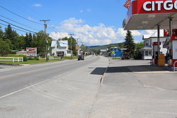
Jackman is part of Forest Hills Consolidated School, which teaches grades kindergarten to grade 12.
Jackman belongs to Maine Area School District 12. [11]
Jackman became connected to the international North American rail network upon completion the International of Maine Division of the transcontinental Canadian Pacific Railway in 1889. [12] Jackman Lumber Company built the Bald Mountain Railroad in 1915 north from Jackman up Heald Stream and across the South Branch Penobscot River into Moose River Plantation. This logging railroad brought logs to the Jackman sawmill until 1926. [13] Passenger rail service through Jackman ended in 1981, resumed in 1985, and ended once more in 1994.
Number | Builder | Type | Date | Works number | Notes [14] |
---|---|---|---|---|---|
Lima Locomotive Works | Shay locomotive | March 24, 1894 | 464 | originally Keystone Railroad #2 of Pennsylvania; purchased from Lye Brook Railroad of Manchester, Vermont | |
Lima Locomotive Works | Shay locomotive | June 26, 1908 | 1970 | originally Beebe River Railroad #2 of Campton, New Hampshire | |
Lima Locomotive Works | Shay locomotive | November 11, 1907 | 2036 | originally Johnson Lumber Company #3 of North Woodstock, New Hampshire |
Bridgewater is a town in Aroostook County, Maine, United States. The population was 532 at the 2020 census.
Masardis is a town in Aroostook County, Maine, United States. The population was 204 at the 2020 census.
New Limerick is a town in Aroostook County, Maine, United States. The population was 574 at the 2020 census. The town was settled in 1775 and incorporated on March 18, 1837, from New Limerick Plantation. It received its name from the fact that many of its settlers had previously lived in Limerick in York County at the southern end of the state, which in turn was probably named after the Irish city of Limerick.
Kingfield is a town in Franklin County, Maine, United States. The population was 960 at the 2020 census. Kingfield, the primary village in the town, is a census-designated place.
New Sharon is a town in Franklin County, Maine, incorporated in 1794. The population was 1,458 at the 2020 census. The town is roughly bisected by the Sandy River, a tributary of the Kennebec River.
Phillips is a town in Franklin County, Maine, United States. The population was 898 at the 2020 census. It is home to the Sandy River and Rangeley Lakes Railroad, a heritage railroad.
Nobleboro, founded in 1788, is a town in Lincoln County, Maine, United States. The population was 1,791 at the 2020 census. Nobleboro is named for Arthur Noble's son Arthur II. Part of Nobleboro was part of Shem Drowne's claim in the 1730s.
Hartford is a town in Oxford County, Maine, United States. Hartford is included in the Lewiston-Auburn, Maine metropolitan New England City and Town Area. The population was 1,203 at the 2020 census.
Hiram is a town in Oxford County, Maine, United States. The population was 1,609 at the 2020 census. It includes the villages of Hiram, East Hiram, South Hiram and Durgintown. Located among the rugged and unspoiled Western Maine Mountains, Hiram is part of the Portland-South Portland-Biddeford, Maine metropolitan New England city and town area.
Roxbury is a town in Oxford County, Maine, United States. The population was 361 at the 2020 census. Ellis Pond is popular with recreational fishermen.
Corinna is a town in Penobscot County, Maine, United States. The population was 2,221 at the 2020 census. It is part of the Bangor metropolitan statistical area. The village of Corinna is in the southern part of the town.
Springfield is a town in Penobscot County, Maine, United States. The population was 293 at the 2020 census.
Brownville is a town in Piscataquis County, Maine, United States. The population was 1,139 at the 2020 census. The town includes the villages of Brownville, Knight's Landing and Brownville Junction, near which passes the 100-Mile Wilderness of the Appalachian Trail.
Jonesboro is a town in Washington County, Maine, United States. The town was named for John Coffin Jones, a landholder. The population was 587 at the 2020 census.
Topsfield is a town in Washington County, Maine, United States. The population was 179 at the 2020 census.
Vanceboro is a town in Washington County, Maine, United States. The town was named after landowner William Vance. The main village in town is located at the eastern terminus of Maine State Route 6. Vanceboro is across the St. Croix River from St. Croix, New Brunswick, Canada, to which it is connected by the Saint Croix–Vanceboro Bridge. Vanceboro is also connected to St. Croix by the Saint Croix–Vanceboro Railway Bridge, which is used by the New Brunswick Southern Railway.
Wesley is a town in Washington County, Maine, United States. The town was named after John Wesley, founder of the English Methodist movement. The population was 122 at the 2020 census.
Greenville is a town in Piscataquis County, Maine, United States. The population was 1,437 at the 2020 census. The town is centered on the lower end of Moosehead Lake, the largest body of fresh water in the state. Greenville is the historic gateway to the north country and a center for outdoor recreation in the area. Greenville High School, with 89 students, was ranked as the third best high school in Maine and one of the top 1,000 in the US in 2010.
Anson is a town in Somerset County, Maine, United States. The population was 2,291 at the time of the 2020 census. It includes the villages of Anson and North Anson.
Bingham is a town in Somerset County, Maine, United States. The population was 866 at the 2020 census. Bingham is a historic town located beside the Kennebec River.