
Ducor is a census-designated place (CDP) in Tulare County, California, United States. The population was 616 at the 2020 census, up from 612 at the 2010 census. Ducor is an abbreviation of an earlier name, Dutch Corners, which was given because several early settler families were German. The word "Dutch" in this case derives from German deutsch "German".

Port LaBelle is a census-designated place (CDP) in Hendry and Glades counties, Florida, United States. The population was 5,450 at the 2020 census, up from 3,530 at the 2010 census. It is part of the Clewiston, Florida Micropolitan Statistical Area (μSA).

Whitmore Village is a census-designated place (CDP) in Honolulu County, Hawaiʻi, United States. The population was 4,887 at the 2020 census.
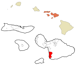
Wailea-Makena was a census-designated place (CDP) in Maui County, Hawaiʻi, United States, during the 2000 census, at which time its population was 5,671. The area was split into two CDPs, Wailea and Makena, for the 2010 census.
Rosewood Heights is an unincorporated community and census-designated place (CDP) in Madison County, Illinois, United States. The population was 3,971 at the 2020 census. It is part of the Metro East region of the Greater St. Louis metropolitan area.

Brunswick Station was a census-designated place (CDP) within the town of Brunswick in Cumberland County, Maine, United States. The population was 578 at the 2010 census. It consists of an area that was part of the former Naval Air Station Brunswick and was part of the Portland–South Portland–Biddeford, Maine Metropolitan Statistical Area. The 2020 census shows it as part of the Brunswick CDP.

Waretown is an unincorporated community and census-designated place (CDP) located on the Jersey Shore within Ocean Township, in Ocean County, in the U.S. state of New Jersey. As of the 2020 United States census, the CDP's population was 1,483, a decrease of 86 (5.5%) from the 1,589 recorded at the 2010 United States Census, which in turn had decreased by 13 (-0.8%) from the 1,582 counted at the 2000 census. Waretown is home to Albert Music Hall.

Mount Healthy Heights is a census-designated place (CDP) in Colerain Township, Hamilton County, Ohio, United States. The population was 2,918 at the 2020 census.

Reedsville is a census-designated place (CDP) in the Kishacoquillas Valley of Mifflin County, Pennsylvania, United States. The population was 641 at the 2010 census. Reedsville has a high Amish population.
Cane Savannah is a census-designated place (CDP) in Sumter County, South Carolina, United States. The population was 1,452 at the 2000 census. It is included in the Sumter, South Carolina Metropolitan Statistical Area.
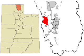
Peter also known as Petersboro is a census-designated place (CDP) on the west-central edge of Cache County, Utah, United States. The population was 324 at the 2010 census. It is included in the Logan, Utah-Idaho (partial) Metropolitan Statistical Area.

Daniels is a census-designated place (CDP) in Raleigh County, West Virginia, United States. The population was 1,881 at the 2010 census.

Topsfield is a census-designated place (CDP) in the town of Topsfield in Essex County, Massachusetts, United States. The population was 2,717 at the 2010 census.

Oakland is a census-designated place (CDP) comprising the main population center in the town of Oakland in Kennebec County, Maine, United States. The population was 2,602 at the 2010 census, out of 6,240 in the entire town of Oakland.
Newport is a census-designated place (CDP) consisting of the main area of settlement within the town of Newport in Penobscot County, Maine, United States. The population of the CDP was 1,776 at the 2010 census.
Hartland is a census-designated place (CDP) in the town of Hartland in Somerset County, Maine, United States. The population was 756 at the 2020 census.
Madison is a census-designated place (CDP) in the town of Madison in Somerset County, Maine, United States. The population was 2,533 at the 2020 census.
Norridgewock is a census-designated place (CDP) in the town of Norridgewock in Somerset County, Maine, United States. The population was 1,351 at the 2020 census.
Pittsfield is a census-designated place (CDP) in the town of Pittsfield in Somerset County, Maine, United States. The population was 3,217 at the 2000 census.

Skowhegan is a census-designated place (CDP) in the town of Skowhegan in Somerset County, Maine, United States. The population was 6,404 at the 2020 census.


