Lead Mountain (Maine)

Last updated
Lead Mountain

Bear Pond and Lead Mountain.JPG

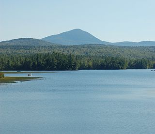
Lead Mountain and Bear Pond from the south
Highest point
Elevation 1479+ ft (451+ m)  NAVD 88 [1]
Prominence 1,120 ft (340 m) [1]
Coordinates 44°51′52″N68°06′37″W / 44.86456°N 68.11032°W / 44.86456; -68.11032 Coordinates: 44°51′52″N68°06′37″W / 44.86456°N 68.11032°W / 44.86456; -68.11032 [2]
Geography
USA Maine location map.svg
Red triangle with thick white border.svg
Lead Mountain
Topo map USGS Lead Mountain
Climbing
Easiest route Hiking, class 1

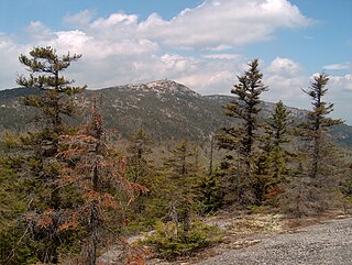
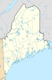
Lead Mountain, at 1,479-foot (451 m) high is a peak in eastern Maine. Lead Mountain is located north of the town of Beddington on the border of Hancock and Washington counties in Downeast Maine. The isolation of Lead Mountain is 35.73 miles, and it is easily visible from miles away along Maine state routes 9 and 193

Maine State of the United States of America

Maine is a state in the New England region of the northeastern United States. Maine is the 12th smallest by area, the 9th least populous, and the 38th most densely populated of the 50 U.S. states. It is bordered by New Hampshire to the west, the Atlantic Ocean to the southeast, and the Canadian provinces of New Brunswick and Quebec to the northeast and northwest respectively. Maine is the easternmost state in the contiguous United States, and the northernmost state east of the Great Lakes. It is known for its jagged, rocky coastline; low, rolling mountains; heavily forested interior; and picturesque waterways, as well as its seafood cuisine, especially lobster and clams. There is a humid continental climate throughout most of the state, including in coastal areas such as its most populous city of Portland. The capital is Augusta.

Beddington, Maine Town in Maine, United States

Beddington is a town in Washington County, Maine, United States. The population was 50 at the 2010 census. It is the smallest organized town in Maine.

Hancock County, Maine County in the United States

Hancock County is a county located in the U.S. state of Maine. As of the 2010 census, the population was 54,418. Its county seat is Ellsworth. The county was incorporated on June 25, 1789 and named for John Hancock, the first governor of the Commonwealth of Massachusetts. The Commissioners are Antonio Blasi, Steven Joy and Percy Brown.

Contents

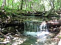
The southern slopes of Lead Mountain are the location of the Bear Brook Watershed in Maine, a long-term research site dedicated to studying the effects of acid deposition on a landscape. [3] Likewise, the southeast slopes of the mountain are drained by Bear Brook. The bedrock of the area contains small blebs of pyrrhotite, which may be mistaken for lead. [4]

Bear Brook Watershed in Maine

The Bear Brook Watershed in Maine (BBWM) is an experimental forest operated by the University of Maine in Hancock County, Maine, United States. The BBWM focuses around the two small first order branches of Bear Brook on the southeastern slopes of Lead Mountain above Bear Pond. Two years of monitoring studies began in 1987, after which the two watersheds of East and West Bear Brook were determined to be nearly identical. The West Bear Brook watershed was experimentally acidified with ammonium sulfate every other month from November 1989 until August 2016 to study the effects of sulfur and nitrogen acid deposition. East Bear Brook has been used as an untreated reference. Related research topics at BBWM include climate change, carbon sequestration, base cation depletion, and watershed biogeochemistry. There are two USGS stream gauges on the East and West Branches of Bear Brook.

Bleb (mineralogy)

In geology, mineralogy, and petrology, a bleb is a small bubble-like inclusion of one mineral within a larger mineral. An example is a bleb of sylvite within chlorite. Blebs tend to be brightly coloured.

Pyrrhotite sulfide mineral; polytypes: 11H, 3T, 4C, 4H, 4M, 5C, 6C, 6M, 7H

Pyrrhotite is an iron sulfide mineral with the formula Fe(1-x)S. It is a nonstoichiometric variant of FeS, the mineral known as troilite. Pyrrhotite is also called magnetic pyrite, because the color is similar to pyrite and it is weakly magnetic. The magnetism decreases as the iron content increases, and troilite is non-magnetic.

Lead Mountain is located on private land, but can be hiked by the public. The primary route to Lead Mountain begins just north of the at the gated end of a dirt road southeast of the peak. [5] The route follows the dirt road beyond the gate before turning up a path that ascends southeast of the summit before continuing up the east side of the mountain to reach the summit.

Dirt road unpaved road made from the native material of the land surface

A dirt road or track is a type of unpaved road made from the native material of the land surface through which it passes, known to highway engineers as subgrade material. Dirt roads are suitable for vehicles; a narrower path for pedestrians, animals, and possibly small vehicles would be called a dirt track—the distinction is not well-defined. Unpaved roads with a harder surface made by the addition of material such as gravel and aggregate (stones), might be referred to as dirt roads in common usage but are distinguished as improved roads by highway engineers.

On a clear day views from the summit stretch to the south to Acadia National Park and the Gulf of Maine. There are two communication towers on the summit. South of the mountain is the small Bear Pond, while the much larger Upper Lead Mountain Pond is west of the mountain.

Acadia National Park national park in the US state of Maine

Acadia National Park is an American national park located in the state of Maine, southwest of Bar Harbor. The park preserves about half of Mount Desert Island, many adjacent smaller islands, and part of the Schoodic Peninsula on the coast of Maine. Acadia was initially designated Sieur de Monts National Monument by proclamation of President Woodrow Wilson in 1916. Sieur de Monts was renamed and redesignated Lafayette National Park by Congress in 1919—the first national park in the United States east of the Mississippi River and the only one in the Northeastern United States. The park was renamed Acadia National Park in 1929. More than 3.5 million people visited the park in 2018.

Gulf of Maine A large gulf of the Atlantic Ocean on the east coast of North America

The Gulf of Maine is a large gulf of the Atlantic Ocean on the east coast of North America. It is bounded by Cape Cod at the eastern tip of Massachusetts in the southwest and by Cape Sable Island at the southern tip of Nova Scotia in the northeast. The gulf includes the entire coastlines of the U.S. states of New Hampshire and Maine, as well as Massachusetts north of Cape Cod, and the southern and western coastlines of the Canadian provinces of New Brunswick and Nova Scotia, respectively.

Bear Pond (Hancock County, Maine)

Bear Pond is a lake in Hancock County, Maine, United States. It is located less than 0.5 miles (0.80 km) west of the Washington County border, approximately 1 mi (1.6 km) southeast of the summit of Lead Mountain, and 1.2 mi (1.9 km) northwest of Maine State Route 9 near the town of Beddington. The inflow to Bear Pond comes primarily from Bear Brook, which drains the southeastern slopes of Lead Mountain, which comprises primarily the Bear Brook Watershed in Maine (BBWM), an experimental forest. There are two USGS stream gauges on the East and West Branches of Bear Brook. An unpaved road provides access to the BBWM from state route 9 and passes about 200 feet (61 m) from the eastern end of the pond. Bear Pond is surrounded by forest and is drained at its western end by the Little Narraguagus River.

Lead Mountain as seen from Lower Lead Mountain Pond, September 2012. Lead Mountain wm1.jpg
Lead Mountain as seen from Lower Lead Mountain Pond, September 2012.

Related Research Articles

Mount Monadnock mountain in New Hampshire, USA

Mount Monadnock, or Grand Monadnock, is a mountain in the New England state of New Hampshire, known for being featured in the writings of Ralph Waldo Emerson and Henry David Thoreau. It is the most prominent mountain peak in southern New Hampshire and is the highest point in Cheshire County. It is located 62 miles (100 km) northwest of Boston and 38 miles (61 km) southwest of Concord, within the towns of Jaffrey and Dublin, New Hampshire. At 3,165 feet (965 m), Mount Monadnock is nearly 1,000 feet (305 m) higher than any other mountain peak within 30 miles (48 km) and rises 2,000 feet (610 m) above the surrounding landscape.

Mount Katahdin highest mountain in the US state of Maine

Mount Katahdin is the highest mountain in the U.S. state of Maine at 5,267 feet (1,605 m). Named Katahdin by the Penobscot Native Americans, which means "The Greatest Mountain", it is located within Northeast Piscataquis, Piscataquis County, and is the centerpiece of Baxter State Park. It is a steep, tall masiff formed from a granite intrusion weathered to the surface. The flora and fauna on the mountain are typical of those found in northern New England.

Mount Kearsarge (Merrimack County, New Hampshire) mountain in United States of America

Mount Kearsarge is a mountain located in Wilmot, New Hampshire, and Warner, New Hampshire. Two state parks are located at the northern and southern bases of the mountain—Winslow State Park and Rollins State Park, respectively—and the entire mountain is within Kearsarge Mountain State Forest. On a very clear day, skyscrapers in the city of Boston 80 miles (130 km) away are visible from the fire tower on the summit. The summit has remained bare since a 1796 forest fire.

Mount Moosilauke mountain in United States of America

Mount Moosilauke is a 4,802-foot-high (1,464 m) mountain at the southwestern end of the White Mountains in the town of Benton, New Hampshire, United States. It is the tenth highest and most southwesterly of the 4,000 foot summits in the White Mountains.

Mount Frissell mountain in United States of America

Mount Frissell, 2,454 feet (748 m), located on the border of southwest Massachusetts and northwest Connecticut, is a prominent peak of the Taconic Range.

Mount Blue (Maine) mountain in United States of America

Mount Blue is a mountain in Maine, USA. It gives its name to Mount Blue State Park in Weld and Mount Blue High School in Farmington.

Mount Sunapee mountain in United States of America

Mount Sunapee is a 5-mile-long (8.0 km) mountain ridge in the towns of Newbury and Goshen in western New Hampshire, United States. Its highest peak, at the north end of the mountain, is 2,726 feet (831 m) above sea level. The mountain has three secondary peaks, White Ledges at 2,716 ft (828 m); North Peak at 2,280 ft (695 m); and South Peak at 2,608 ft (795 m). The north end of the mountain, including the summit, is within Mount Sunapee State Park, which encompasses 3.85 square miles (10.0 km2) and is home to the popular Mount Sunapee Resort. The mountain extends south to Pillsbury State Park in the towns of Goshen and Washington.

Mount Cardigan mountain in United States of America

Mount Cardigan is a prominent bare-rock summit in the towns of Orange and Alexandria in western New Hampshire, USA. While its peak is only 3,155 feet (962 m) above sea level, it has extensive areas of bare granite ledges and alpine scrub, giving it the feel to hikers of a much higher mountain. Most of the summit area was denuded by devastating forest fires in 1855.

Ragged Mountain (New Hampshire) mountain in United States of America

Ragged Mountain is a low mountain with numerous knobby summits in the towns of Danbury and Andover in central New Hampshire. It is home to the Ragged Mountain ski resort.

Sunday River Whitecap mountain in United States of America

Sunday River Whitecap is a 3,335 ft (1,017 m) mountain located in Oxford County, Maine, United States. It is flanked to the west by Slide Mountain, and to the southeast by Stowe Mountain.

Mount Tripyramid (New Hampshire) mountain in United States of America

Mount Tripyramid is a mountain located in Grafton County, New Hampshire. The mountain, so-called because of the three distinct peaks along its mile-long summit ridge, is part of the Sandwich Range of the White Mountains. Scaur Peak and The Fool Killer are subsidiary peaks to the northwest and northeast. To the southeast, Tripyramid is flanked by The Sleepers.

Coburn Mountain (Maine) mountain in United States of America

Coburn Mountain is a mountain located in Somerset County, Maine.

Traveler Mountain mountain in United States of America

Traveler Mountain is a mountain located in Piscataquis County, Maine, in Baxter State Park. The Traveler, is the eighth-most prominent in Maine. Subsidiary peaks include the Peak of the Ridges 3,225 ft (983 m) North and South Traveler Mountain 3,144 ft (958 m) and 2,677 ft (816 m), respectively.

Tumbledown Mountain mountain in Maine, United States of America

Tumbledown Mountain is a mountain in Franklin County, Maine. The mountain is a popular hiking spot in western Maine, with trailheads located on Byron Road in unincorporated Township 6, north of Weld. It is distinguished by an alpine pond just below the summit. Tumbledown Mountain is also located near Coos Canyon, a mountain stream. Tumbledown offers trails of varying difficulty for different hikers.

Tully Mountain mountain in Massachusetts

Tully Mountain, 1,163 ft (354 m), is a prominent, steep-sided monadnock located in north central Massachusetts in the town of Orange. It is part of the Tully Mountain Wilderness Management Area. An exposed east facing ledge on the summit provides views of the Millers River valley, Mount Monadnock, Mount Wachusett, and the Wapack Range. The 22-mile (35 km) Tully Trail traverses the mountain.

Graham Mountain (New York) Highest privately owned summit in New Yorks Catskill Mountains

Graham Mountain is the seventh highest of the Catskill High Peaks and the highest privately owned mountain in the range. It is located in the town of Hardenburgh, New York, United States.

Brace Mountain mountain in United States of America

Brace Mountain is the peak of a ridge in the southern Taconic Mountains, near the tripoint of the U.S. states of New York, Connecticut and Massachusetts. Its 2,311-foot (704 m) main summit is located in New York; it is the highest point in that state's Dutchess County.

The Sebec River is a tributary of the Piscataquis River in Piscataquis County, Maine. From the outflow of Sebec Lake in Sebec, the river runs 10.0 miles (16.1 km) east and southeast to its confluence with the Piscataquis in Milo.

Elephant Mountain (Piscataquis County, Maine) mountain in Maine United States of America

Elephant Mountain is a mountain located in Bowdoin College Grant West Piscataquis County, Maine. It is about 5 miles (8 km) southeast of Moosehead Lake, 2 miles southwest of Baker Mountain, and 5 miles west of White Cap Mountain.

References

  1. 1 2 "Lead Mountain, Maine". Peakbagger.com. Retrieved 2012-04-24.
  2. "Lead Mountain". Geographic Names Information System . United States Geological Survey . Retrieved 2013-01-14.
  3. "Bear Brook Watershed in Maine". The University of Maine. Retrieved 2012-04-24.
  4. Caldwell, Dabney W. (1998). Roadside Geology of Maine. Missoula, Montana: Mountain Press Publishing Company. p. 104. ISBN   9780878423750.
  5. "Lead Mountain, ME". High-Powered Planet. Retrieved 2012-04-24.