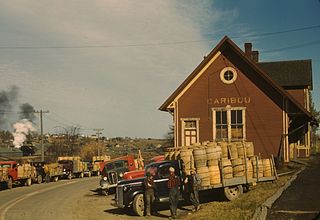
Caribou is the second largest city in Aroostook County, Maine, United States. Its population was 7,396 at the 2020 census. The city is a service center for the agricultural and tourism industries, and the location of a National Weather Service Forecast Office.

Cascade Mountain is in Essex County of New York. It is one of the 46 Adirondack High Peaks (36th) and is located in the Adirondack Park. Its name comes from a series of waterfalls on a brook near the mountain's base. The lake it flows into and the pass between Cascade and Pitchoff mountains are also named Cascade.

The White Mountain National Forest (WMNF) is a federally managed forest contained within the White Mountains in the northeastern United States. It was established in 1918 as a result of the Weeks Act of 1911; federal acquisition of land had already begun in 1914. It has a total area of 750,852 acres (303,859 ha). Most of the WMNF is in New Hampshire; a small part is in the neighboring state of Maine. Conservationist and community activist Katherine Sleeper Walden was instrumental in securing at-risk land for the forest, including thousands of acres in the region surrounding the locally famous Bowl near Wonalancet.

Bear Rocks is a widely recognized symbol of West Virginia wilderness and among the most frequently photographed places in the state. It is a well-known landmark on the eastern edge of the plateau that includes the Dolly Sods Wilderness. It sits in a high-elevation heathland punctuated with wind-carved sandstone outcrops and is home to more than a dozen rare plant and animal species. Situated on the crest of the Allegheny Front, Bear Rocks afford vistas over the South Branch Potomac River. Visibility can extend eastward to the Shenandoah National Park in Virginia.

Vaccinium angustifolium, commonly known as the wild lowbush blueberry, is a species of blueberry native to eastern and central Canada and the northeastern United States, growing as far south as the Great Smoky Mountains and west to the Great Lakes region. Vaccinium angustifolium is the most common species of the commercially used wild blueberries and is considered the "low sweet" berry.

Crouseville is an unincorporated village located within the town of Washburn in Aroostook County, Maine, United States.

The Carrabassett River, a tributary of the Kennebec River, is located in Franklin County and Somerset County, Maine, in the United States. It rises near Sugarloaf Mountain, east of Rangeley Lake, and runs for 33.8 miles (54.4 km), flowing southeast past Kingfield and joining the Kennebec River in the town of Anson.
Mount Whiteface is a 4,019 ft (1,225 m) mountain located in Grafton County, New Hampshire. The mountain is part of the Sandwich Range of the White Mountains. Whiteface is flanked to the northwest by Mount Tripyramid, and to the northeast by Mount Passaconaway. Whiteface is on the eastern border of the Sandwich Range Wilderness. To the east, between Whiteface, Passaconaway, and Mt. Wonalancet, lies The Bowl natural area, an unlogged cirque.

Old Speck Mountain, also known as Old Speckle Mountain, is a mountain located in Oxford County, Maine, United States. The mountain, the fourth-highest in the state, is the northeasternmost and highest of the Mahoosuc Range, the northeasternmost part of the White Mountains. Old Speck is flanked to the southwest by Mahoosuc Arm, and faces Baldpate Mountain to the northeast across Grafton Notch.

Sandwich Mountain is a 3,983 ft (1,214 m) mountain located on the border between Carroll and Grafton counties, New Hampshire spanning parts of the towns of Sandwich and Waterville Valley, respectively. The mountain is part of the Sandwich Range of the White Mountains.

South Crocker Mountain is a mountain located in Franklin County, Maine. South Crocker Mountain is flanked to the north by Crocker Mountain, and to the southwest by Mount Redington.
Coburn Mountain is a mountain located in Somerset County, Maine.

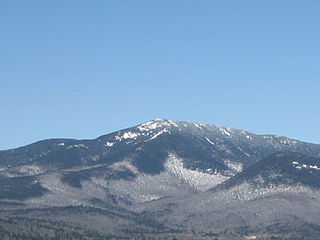
Caribou Mountain is a mountain on the Canada–United States border, the section of which follows the height of land of the Saint Lawrence River watershed. The peak is located about 0.5 mi (0.80 km) inside Franklin County, Maine. The southwest end of Caribou's summit ridge is in Le Granit Regional County Municipality, Québec.
Big Spencer Mountain is a mountain located in Piscataquis County, Maine. Big Spencer Mtn. is flanked to the west by Little Spencer Mountain.

The New England-Acadian forests are a temperate broadleaf and mixed forest ecoregion in North America that includes a variety of habitats on the hills, mountains and plateaus of New England and New York State in the Northeastern United States, and Quebec and the Maritime Provinces of Eastern Canada.
Bickford Slides is a 90-foot (30 m) waterfall in the town of Stow, Maine, United States. Located on Bickford Brook within the White Mountain National Forest's Caribou-Speckled Mountain Wilderness, it consists of two tiers of cascades and slides, the upper tier 40 feet high and the lower tier 50 feet high.
Blueberry Mountain is a mountain located in western Maine. Named because of the abundant blueberries on its summit and upper slopes, it is a popular day hike. The summit area is partially open and has good views over Evans Notch and toward North and South Baldface in New Hampshire. It is ascended by the White Cairn, Stone House, and Blueberry Ridge trails. It is considered a spur of Speckled Mountain.

The Baldface-Royce Range is a range of mountains in western Maine and eastern New Hampshire, in the United States. They are located in the town of Chatham, New Hampshire, and the townships of Bean's Purchase, New Hampshire, and Batchelders Grant, Maine, in the eastern part of the White Mountains.

Evans Notch is a mountain pass located in the White Mountains in Maine, United States, about 1 mile (1.6 km) east of the New Hampshire border. It is the easternmost notch through the White Mountains. To the south, the notch is drained by the Cold River, which leads via the Charles River to the Saco River, which in turn flows into the Gulf of Maine east of Saco and Biddeford. The Mad River is a small mountain stream that joins the Cold River from the west about 2 miles (3 km) south of the height of land, after dropping over Mad River Falls. The notch is drained to the north by Evans Brook, a tributary of the Wild River, which flows north to the Androscoggin River. The Androscoggin leads east and south to the Kennebec River at Merrymeeting Bay north of Bath, Maine.

The Brickett Place is a historic farmstead in rural Oxford County, Maine, United States. It is located in the White Mountain National Forest on Maine State Route 113, in the small town of Stow. Built from 1812 to 1816 by John Brickett out of handmade bricks, it is an idiosyncratic expression of Federal architecture in an unusually remote setting, and is the oldest building in the United States Forest Service's Eastern Region. It was listed on the National Register of Historic Places in 1982. It is currently used by the United States Forest Service as a seasonal visitors center, with interpretive displays about the area's history.