List of New England Hundred Highest

Last updated

The New England Hundred Highest is a list of the hundred highest summits in New England, used in the mountaineering sport of peak bagging. The list is a superset of the New England Four-thousand footers, with the same requirement that each included peak must have 200 feet (61 meters) of topographic prominence ("optimistic" prominence, equivalent to 160 ft (49 m) of "clean" prominence).

Contents

The order and elevation figures are those listed on the official list; other sources may differ.

List

RankNameStateElevation
1 Mount Washington New Hampshire  6,288 ft(1,917 m)  
2 Mount Adams New Hampshire5,774 ft(1,760 m)
3 Mount Jefferson New Hampshire5,712 ft(1,741 m)
4 Mount Monroe New Hampshire5,384 ft(1,641 m)
5 Mount Madison New Hampshire5,367 ft(1,636 m)
6 Katahdin, Baxter Peak Maine 5,268 ft(1,606 m)
7 Mount Lafayette New Hampshire5,249 ft(1,600 m)
8 Mount Lincoln New Hampshire5,089 ft(1,551 m)
9 South Twin Mountain New Hampshire4,902 ft(1,494 m)
10 Carter Dome New Hampshire4,832 ft(1,473 m)
11 Mount Moosilauke New Hampshire4,802 ft(1,464 m)
12 Mount Eisenhower New Hampshire4,780 ft [1] (1,460 m)
13 North Twin Mountain New Hampshire4,761 ft(1,451 m)
14 Katahdin, Hamlin PeakMaine4,756 ft(1,450 m)
15 Mount Carrigain New Hampshire4,700 ft [1] (1,435 m)
16 Mount Bond New Hampshire4,698 ft(1,432 m)
17 Middle Carter Mountain New Hampshire4,610 ft [1] (1,405 m)
18 West Bond New Hampshire4,540 ft [1] (1,385 m)
19 Mount Garfield New Hampshire4,500 ft [1] (1,370 m)
20 Mount Liberty New Hampshire4,459 ft(1,359 m)
21 South Carter Mountain New Hampshire4,430 ft [1] (1,350 m)
22 Wildcat Mountain, "A" PeakNew Hampshire4,422 ft(1,348 m)
23 Mount Hancock New Hampshire4,420 ft [1] (1,345 m)
24 Mount Mansfield Vermont 4,393 ft(1,339 m)
25 Kinsman Mountain, South PeakNew Hampshire4,358 ft(1,328 m)
26 Mount Field New Hampshire4,340 ft [1] (1,325 m)
27 Mount Osceola New Hampshire4,340 ft [1] (1,325 m)
28 Mount Flume New Hampshire4,328 ft(1,319 m)
29 Mount Hancock, South PeakNew Hampshire4,319 ft(1,316 m)
30 Mount Pierce New Hampshire4,310 ft(1,314 m)
31 Kinsman Mountain, North PeakNew Hampshire4,293 ft(1,309 m)
32 Mount Willey New Hampshire4,285 ft(1,306 m)
33 Bondcliff New Hampshire4,265 ft(1,300 m)
34 Mount Zealand New Hampshire4,260 ft [1] (1,300 m)
35 Sugarloaf Mountain Maine4,250 ft [1] (1,295 m)
36 Killington Peak Vermont4,235 ft(1,291 m)
37 Crocker Mountain Maine4,228 ft(1,289 m)
38 Mount Tripyramid, North PeakNew Hampshire4,180 ft [1] (1,275 m)
39 Mount Cabot New Hampshire4,170 ft [1] (1,270 m)
40 Old Speck Mountain Maine4,170 ft [1] (1,270 m)
41 East Osceola New Hampshire4,156 ft(1,267 m)
42 North Brother Maine4,151 ft(1,265 m)
43 Mount Bigelow, West PeakMaine4,145 ft(1,263 m)
44 Mount Tripyramid, Middle PeakNew Hampshire4,140 ft [1] (1,260 m)
45 Saddleback Mountain Maine4,120 ft(1,256 m)
46 Cannon Mountain New Hampshire4,100 ft [1] (1,250 m)
47 Mount Bigelow, Avery PeakMaine4,090 ft [1] (1,245 m)
48 Camel's Hump Vermont4,083 ft(1,244 m)
49 Mount Ellen Vermont4,083 ft(1,244 m)
50 Mount Hale New Hampshire4,054 ft(1,236 m)
51 Mount Jackson New Hampshire4,052 ft(1,235 m)
52 Mount Tom New Hampshire4,051 ft(1,235 m)
53 Mount Abraham Maine4,050 ft [1] (1,235 m)
54 South Crocker Mountain Maine4,050 ft [1] (1,235 m)
55 Wildcat Mountain, "D" PeakNew Hampshire4,050 ft [1] (1,235 m)
56 Mount Moriah New Hampshire4,049 ft(1,234 m)
57 Mount Passaconaway New Hampshire4,043 ft(1,232 m)
58 Owl's Head New Hampshire4,025 ft(1,227 m)
59 Galehead Mountain New Hampshire4,024 ft(1,227 m)
60 Saddleback Horn Maine4,023 ft(1,226 m)
61 Mount Whiteface New Hampshire4,020 ft [1] (1,225 m)
62 Mount Redington Maine4,010 ft [1] (1,220 m)
63 Spaulding Mountain Maine4,010 ft [1] (1,220 m)
64 Mount Abraham Vermont4,006 ft(1,221 m)
65 Mount Waumbek New Hampshire4,006 ft(1,221 m)
66 Mount Isolation New Hampshire4,004 ft(1,220 m)
67 Mount Tecumseh New Hampshire3,997 ft(1,218 m)
68 Sandwich Mountain New Hampshire3,980 ft [1] (1,215 m)
69 South Brother Maine3,970 ft(1,210 m)
70 Snow Mountain Maine3,960 ft(1,207 m)
71 Pico Peak Vermont3,957 ft(1,206 m)
72 The Bulge New Hampshire3,950 ft [1] (1,205 m)
73 Stratton Mountain Vermont3,940 ft(1,201 m)
74 Mount Nancy New Hampshire3,926 ft(1,197 m)
75 The Horn New Hampshire3,905 ft(1,190 m)
76 Mount Weeks New Hampshire3,901 ft(1,189 m)
77 South Weeks New Hampshire3,885 ft(1,184 m)
78 Goose Eye Mountain Maine3,870 ft [1] (1,180 m)
79 Vose Spur New Hampshire3,862 ft(1,177 m)
80 Fort Mountain Maine3,861 ft(1,177 m)
81 Jay Peak Vermont3,858 ft(1,176 m)
82 White Cap Mountain Maine3,856 ft(1,175 m)
83"Boundary Peak" [2] Maine3,855 ft(1,175 m)
84 Equinox Mountain Vermont3,850 ft [1] (1,175 m)
85 Mendon Peak Vermont3,850 ft [1] (1,175 m)
86 The Sleepers, East PeakNew Hampshire3,840 ft [1] (1,170 m)
87 Bread Loaf Mountain Vermont3,835 ft(1,169 m)
88"Nubble Peak" [3] New Hampshire3,813 ft(1,162 m)
89 Mount Bigelow, South HornMaine3,805 ft(1,160 m)
90 Mount Coe Maine3,795 ft(1,157 m)
91 East Kennebago Mountain Maine3,791 ft(1,155 m)
92 Mount Wilson Vermont3,790 ft [1] (1,155 m)
93 Big Jay Vermont3,786 ft(1,154 m)
94 Snow Mountain Maine3,784 ft(1,153 m)
95 Baldpate Mountain Maine3,780 ft [1] (1,150 m)
96 Kennebago Divide Maine3,775 ft(1,151 m)
97 Scar Ridge New Hampshire3,774 ft(1,151 m)
98 Elephant Mountain Maine3,772 ft(1,150 m)
99 Dorset Mountain Vermont3,770 ft [1] (1,150 m)
100 The Cannon Balls, NE PeakNew Hampshire3,769 ft(1,149 m)

See also

Notes

  1. 1 2 3 4 5 6 7 8 9 10 11 12 13 14 15 16 17 18 19 20 21 22 23 24 25 26 27 28 29 30 31 32 Elevation estimated, by adding half of the contour interval to the highest contour line. Metric conversions are rounded to nearest 5 metres.
  2. This peak on the Maine-Quebec border has no official name.
  3. This peak has no official name. The unofficial name references a rocky subpeak to the northwest, the Nubble, elevation 2,713 ft, which is also called Haystack Mountain. Nubble Peak is also known by the more accurate but longer name "Peak above the Nubble" or confused with the subpeak and simply called "The Nubble".

Related Research Articles

Presidential Range

The Presidential Range is a mountain range located in the White Mountains of the U.S. state of New Hampshire. Containing the highest peaks of the Whites, its most notable summits are named for American presidents, followed by prominent public figures of the 18th and 19th centuries. The Presidential Range is notorious for having some of the worst weather on Earth, mainly because of the unpredictability of high wind speeds and whiteout conditions on the higher summits. Because of the poor weather conditions, the Presidential Range is often used for mountaineering training for those who go on to climb some of the world's highest mountains, including K2 and Everest.

Topographic prominence Characterizes the height of a mountain or hills summit by the vertical distance between it and the lowest contour line encircling it but containing no higher summit within it; it is a measure of the independence of a summit

In topography, prominence measures the height of a mountain or hill's summit relative to the lowest contour line encircling it but containing no higher summit within it. It is a measure of the independence of a summit. A peak's key col is a unique point on this contour line and the parent peak is some higher mountain, selected according to various criteria.

Summit Point on a surface with a higher elevation than all immediately adjacent points

A summit is a point on a surface that is higher in elevation than all points immediately adjacent to it. The topographic terms acme, apex, peak, and zenith are synonymous.

Mount Eisenhower

Mount Eisenhower, formerly Mount Pleasant, is a mountain in the Presidential Range in the White Mountains of New Hampshire approximately 4,760 ft (1,450 m) high. Named after President Dwight D. Eisenhower, its summit offers a 360° view. It is inaccessible by road.

Four-thousand footers are a group of forty-eight mountains in New Hampshire at least 4,000 feet (1,200 m) above sea level. To qualify for inclusion a peak must also meet the more technical criterion of topographic prominence important in the mountaineering sport of peak-bagging.

Mount Moosilauke

Mount Moosilauke is a 4,802-foot-high (1,464 m) mountain at the southwestern end of the White Mountains in the town of Benton, New Hampshire, United States. It is the tenth highest and most southwesterly of the 4,000 foot summits in the White Mountains.

Mount Monroe

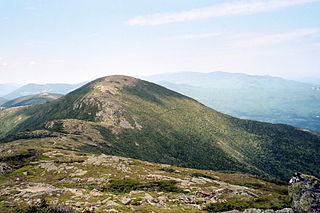
Mount Monroe is a 5,372-foot-high (1,637 m) mountain peak southwest of Mount Washington in the Presidential Range of the White Mountains in New Hampshire, United States. It is named for American President James Monroe and is the fourth highest mountain on the 4000 footers list for New Hampshire. The Appalachian Trail skirts its summit, which is the next highest peak on or near the trail north of Mount Rogers in Virginia. The Lakes of the Clouds, and its AMC hut, lie nestled at the col between Mount Monroe and neighboring Mount Washington.

East Peak Mount Osceola

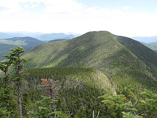
The East Peak of Mount Osceola is one of the official New Hampshire 4000-footers, standing at an elevation of 4,156 feet (1,267 m). East Osceola's prominence is between 316 feet (96 m) and 356 feet (109 m), with the key saddle between it and Mount Osceola. It can be approached via the Greeley Ponds trail from the Kancamagus Highway or from the summit of neighboring Osceola. Both routes are not without difficulties; the trail from the ponds is extremely steep and prolonged, and the approach from Osceola contains a chimney, along with a less hazardous bypass by way of the saddle connecting the peaks. The summit is nondescript and surrounded by trees.

Lists of mountains and hills in the British Isles Highest mountains in the British Isles

The mountains and hills of the British Isles are categorised into various lists based on different combinations of elevation, prominence, and other criteria such as isolation. These lists are used for peak bagging, whereby hillwalkers attempt to reach all the summits on a given list, the oldest being the 282 Munros in Scotland, created in 1891.

Wildcat Mountain (New Hampshire)

Wildcat Mountain is a mountain located in Coos County, northern New Hampshire, United States. The mountain is part of the Carter-Moriah Range of the White Mountains, on the east side of Pinkham Notch. Wildcat Mountain faces Carter Dome across Carter Notch to the northeast, and Mount Washington across Pinkham Notch to the west.

Carter-Moriah Range

The Carter-Moriah Range of mountains is located in the White Mountains, in Coos County, New Hampshire. The range forms the northern east side of Pinkham Notch, opposite the northern Presidential Range. The range is also referred to as the Carter Range.

Mount Bigelow (Maine)

Mount Bigelow is a long mountain ridge with several summits. It is located in Franklin County and Somerset County, Maine. It is one of Maine's highest summits. The mountain is named after Major Timothy Bigelow who climbed the rugged summit in late October 1775 "for the purpose of observation." Major Bigelow was one of Colonel Benedict Arnold's four division commanders during the 1775 Invasion of Canada. The expeditionary force passed along the Dead River on the northern edge of the Bigelow Range, now dammed into Flagstaff Lake.

Northeast 111

The Northeast 111 is a peak-bagging list of 4,000-foot (1,219.2 m) mountains in the northeastern states of the United States. It includes the sixty-seven 4000-footers of New England, the 46 Adirondack High Peaks, and Slide and Hunter Mountain, both in the Catskills of New York.

Mount Cabot is a mountain located in Coos County, in the U.S. state of New Hampshire. The mountain is the highest peak of the Pilot Range of the White Mountains. Cabot is flanked to the northeast by The Bulge, and to the south of Bunnell Notch by Terrace Mountain. Mount Cabot was named in honor of the Italian explorer Sebastian Cabot.