List of Nebraska state parks

Last updated

USA Nebraska relief location map.svg
Green pog.svg
Chadron
Green pog.svg
Mahoney
Green pog.svg
Fort Robinson
Green pog.svg
Indian Cave
Green pog.svg
Niobrara
Green pog.svg
Platte River
Green pog.svg
Ponca
Green pog.svg
Smith Falls
Nebraska State Parks: hover mouse over green pog for clickable link.

This is a list of state parks in the U.S. state of Nebraska; the state park system is divided into state parks, state historical parks, state recreation areas and a state recreational trail. The parks are managed by the Nebraska Game and Parks Commission.

Contents

State parks

Name  [1] County  Size [2] Image  Notes  
acresha
Chadron State Park Dawes 974.26 acres394.27 ha Chadron State Park.jpg Nebraska's oldest state park
Eugene T. Mahoney State Park Cass 673.101 acres272.394 ha Platte River.jpg Multiple recreational and meeting facilities, fronted by the Platte River
Fort Robinson State Park Dawes,
Sioux
22,332.72 acres9,037.73 ha Fort Robinson Comanche Hall from W.jpg Former U.S. Army fort
Indian Cave State Park Nemaha,
Richardson
3,399.7 acres1,375.8 ha Indian Cave State Park.jpg Petroglyphs; restored village of St. Deroin
Niobrara State Park Knox 1,236.59 acres500.43 ha Niobrara State Park bridge E end.JPG

Includes the historic Niobrara River railroad bridge

Platte River State Park Cass 452.5 acres183.1 ha Tower Platte River.jpg Modern observation towers, vintage cabins from earlier campgrounds
Ponca State Park Dixon 2,123.63 acres859.40 haOn the banks of the Missouri River
Smith Falls State Park Cherry 265.5 acres107.4 ha SmithFallsNE.jpg Nebraska's highest waterfall
USA Nebraska relief location map.svg
Red pog.svg
Arbor Lodge
Red pog.svg
Ash Hollow
Red pog.svg
Ashfall Fossil Beds
Red pog.svg
Bowring Ranch
Red pog.svg
Buffalo Bill Ranch
Red pog.svg
Fort Atkinson
Red pog.svg
Fort Hartsuff
Red pog.svg
Fort Kearny
Red pog.svg
Rock Creek Station
Nebraska State Historical Parks: Hover mouse over red pog for clickable link.

State historical parks

Name  [3] County  Size [2] Image  Notes  
acresha
Arbor Lodge State Historical Park Otoe 73.85 acres29.89 ha Arbor Lodge 2008 3.jpg Estate of J. Sterling Morton, founder of Arbor Day.
Ash Hollow State Historical Park Garden 1,001.03 acres405.10 ha Ash Hollow P7170172 Valley of North Platte.jpg Major stopover on the Overland Trail
Ashfall Fossil Beds State Historical Park Antelope 360 acres150 ha Ashfall Fossil Beds - 1978-79 quarry.JPG Fossil remains at a 12-million-year-old watering hole
Bowring Ranch State Historical Park Cherry 435 acres176 haHereford demonstration ranch donated by former U.S. Senator Eve Bowring
Buffalo Bill Ranch State Historical Park Lincoln 24.68 acres9.99 ha Scouts Rest NE.JPG 
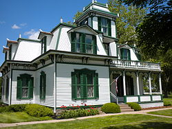
Home of the famed frontier showman
Fort Atkinson State Historical Park Washington 154.36 acres62.47 ha Powder magazine Fort Atkinson.jpg Reconstruction of the first U.S. military post west of the Missouri River
Fort Hartsuff State Historical Park Valley 18.4 acres7.4 ha Fort Hartsuff compound 4.JPG Typical infantry outpost of the 19th century Plains
Fort Kearny State Historical Park Buffalo 39.21 acres15.87 ha Reconstructed Blacksmith shop made of sod.jpg Partial reconstruction of fort that protected travelers of the Overland Trail
Rock Creek Station State Historical Park Jefferson 353 acres143 ha Rock Creek Station SHP East Ranch 2.JPG Partially reconstructed stagecoach and Pony Express station

State recreation areas

State recreational trail

Related Research Articles

<span class="mw-page-title-main">North Platte River</span> River in the Western United States

The North Platte River is a major tributary of the Platte River and is approximately 716 miles (1,152 km) long, counting its many curves. In a straight line, it travels about 550 miles (890 km), along its course through the U.S. states of Colorado, Wyoming, and Nebraska.

<span class="mw-page-title-main">American Discovery Trail</span> Long-distance hiking trail across the United States

The American Discovery Trail is a system of recreational trails and roads that collectively form a coast-to-coast hiking and biking trail across the mid-tier of the United States. Horses can also be ridden on most of this trail. The coastal trailheads are the Delmarva Peninsula on the Atlantic Ocean and the northern California coast on the Pacific Ocean. The trail has northern and southern alternates for part of its distance, passing through Chicago and St. Louis respectively. The total length of the trail, including both the north and south routes, is 6,800 miles (10,900 km). The northern route covers 4,834 miles (7,780 km) with the southern route covering 5,057 miles (8,138 km). It is the only non-motorized coast-to-coast trail.

<span class="mw-page-title-main">Fort Kearny</span> United States historic place

Fort Kearny was a historic outpost of the United States Army founded in 1848 in the western U.S. during the middle and late 19th century. The fort was named after Col. and later General Stephen Watts Kearny. The outpost was located along the Oregon Trail near Kearney, Nebraska. The town of Kearney took its name from the fort. The "e" was added to Kearny by postmen who consistently misspelled the town name. A portion of the original site is preserved as Fort Kearny State Historical Park by the Nebraska Game and Parks Commission.

<span class="mw-page-title-main">Nebraska Game and Parks Commission</span> U.S. state government agency

The Nebraska Game and Parks Commission (NGPC) is the State of Nebraska's State agency charged with stewardship of the state's fish, wildlife, state park, and outdoor recreation resources. The agency is led by a governor-appointed member commission consisting of 9 commissioners which directs agency management. The commission is also charged with issuing of state hunting licenses, fishing licenses, and boat registrations. The agency also manages State Parks and recreation areas throughout the state. It conducts public education programs for hunting and boating safety. The agency is headquartered in Lincoln, Nebraska.

<span class="mw-page-title-main">Curecanti National Recreation Area</span> National Park Service in Colorado, US

Curecanti National Recreation Area is a National Park Service unit located on the Gunnison River in western Colorado. Established in 1965, Curecanti National Recreation Area is responsible for developing and managing recreational facilities on three reservoirs, Blue Mesa Reservoir, Morrow Point Reservoir and Crystal Reservoir, constructed on the upper Gunnison River in the 1960s by the U.S. Bureau of Reclamation to better utilize the vital waters of the Colorado River and its major tributaries. A popular destination for boating and fishing, Curecanti offers visitors two marinas, traditional and group campgrounds, hiking trails, boat launches, and boat-in campsites. The state's premiere lake trout and Kokanee salmon fisheries, Curecanti is a popular destination for boating and fishing, and is also a popular area for ice-fishing in the winter months.

Nebraska Public Power District (NPPD) is the largest electric utility in the state of Nebraska, serving all or parts of 84 counties. It was formed on January 1, 1970, when Consumers Public Power District, Platte Valley Public Power and Irrigation District (PVPPID) and Nebraska Public Power System merged to become Nebraska Public Power District. NPPD's predecessors were created through the efforts of the Nebraska legislature and financial agent Guy L. Myers as part of a system where all the investor-owned utilities operating in the state of Nebraska were condemned and their properties turned over to 'public power districts' being created at the time. NPPD is a public corporation and political subdivision of the state of Nebraska. The utility is governed by an 11-member Board of Directors, who are popularly elected from NPPD's chartered territory.

<span class="mw-page-title-main">Rock Creek Station</span> Park in Nebraska, USA

Rock Creek Station was a stagecoach and Pony Express station in southeastern Nebraska, three miles northeast of the present-day village of Endicott. The site is preserved as Rock Creek Station State Historical Park.

<span class="mw-page-title-main">Lahontan State Recreation Area</span> Recreation area in Nevada, United States

Lahontan State Recreation Area is a public recreation area surrounding Lake Lahontan, a 17-mile-long (27 km) impoundment of the Carson River, located approximately 18 miles (29 km) west of Fallon, Nevada. The reservoir features 69 miles (111 km) of shoreline and 11,200 acres (4,500 ha) of water when full. Much of the park lies below 4,000 feet (1,200 m) in elevation and is dominated by high desert sagebrush. Wooded areas of native cottonwoods and willow trees can be found along the shore of the lake. Primary access points to the park are along U.S. Route 50 near the Lahontan Dam and off U.S. Route 95 in the town of Silver Springs. A corridor known as Carson River Ranches connects Lahontan with Fort Churchill State Historic Park.

<span class="mw-page-title-main">Buffalo Bill Ranch</span> Historic house in Nebraska, United States

Buffalo Bill Ranch State Historical Park, known as Scout's Rest Ranch, is a living history state park located west of North Platte, Nebraska. The ranch was established in 1878 with an initial purchase of 160 acres south of the Union Pacific tracks by William Cody. The 4,000 acre ranch was sold in 1911 and has been under the management of the Nebraska Game and Parks Commission since 1964. The 25 acre historic state park, added to the National Register of Historic Places in 1978 and designated a National Historic Landmark in 2021, is open weekdays from April to October. The house and outbuildings can be toured, including a museum documenting Cody's life from a Pony Express rider to his Wild West shows.

<span class="mw-page-title-main">Lewis and Clark Lake</span> Man-made lake in Nebraska and South Dakota, United States

Lewis and Clark Lake is a 31,400 acre (130 km²) reservoir located on the border of the U.S. states of Nebraska and South Dakota on the Missouri River. The lake is approximately 25 miles (40 km) in length with over 90 miles (140 km) of shoreline and a maximum water depth of 45 feet (14 m). The lake is impounded by Gavins Point Dam and is managed by the U.S. Army Corps of Engineers, Omaha District.

The Missouri National Recreational River is a National Recreational River located on the border between Nebraska and South Dakota. The designation was first applied in 1978 to a 59-mile section of the Missouri River between Gavins Point Dam and Ponca State Park. In 1991, an additional 39-mile section between Fort Randall Dam and Niobrara, Nebraska, was added to the designation. These two stretches of the Missouri River are the only parts of the river between Montana and the mouth of the Missouri that remain undammed or unchannelized. The last 20 miles of the Niobrara River and 6 miles of Verdigre Creek were also added in 1991.

<span class="mw-page-title-main">Crooked River (Oregon)</span> River in Oregon, United States

The Crooked River is a tributary, 125 miles (201 km) long, of the Deschutes River in the U.S. state of Oregon. The river begins at the confluence of the South Fork Crooked River and Beaver Creek. Of the two tributaries, the South Fork Crooked River is the larger and is sometimes considered part of the Crooked River proper. A variant name of the South Fork Crooked River is simply "Crooked River". The Deschutes River flows north into the Columbia River.

<span class="mw-page-title-main">Lake Francis Case</span> Reservoir in South Dakota, United States

Lake Francis Case is a large reservoir impounded by Fort Randall Dam on the Missouri River in south-central South Dakota, United States. The lake has an area of 102,000 acres (410 km2) and a maximum depth of 140 ft (43 m). Lake Francis Case has a length of approximately 107 mi (172 km) and has a shoreline of 540 mi (870 km). The lake is the eleventh-largest reservoir in the United States and is located within the counties of: Charles Mix, Gregory, Lyman, Brule, and Buffalo. The lake stretches from Pickstown, South Dakota upstream to Big Bend Dam.

<span class="mw-page-title-main">Department of the Platte</span> Military unit

The Department of the Platte was a military administrative district established by the U.S. Army on March 5, 1866, with boundaries encompassing Iowa, Nebraska, Dakota Territory, Utah Territory and a small portion of Idaho. With headquarters in Omaha, the district commander oversaw the army's role initially along the Overland route to Salt Lake City, then later the construction route of the Union Pacific Railroad. The district also included the Montana road through eastern Wyoming. The district was discontinued when the Army's command was reorganized in 1898.

<span class="mw-page-title-main">Geography of Colorado Springs, Colorado</span>

Colorado Springs geography describes geographical topics regarding the city of Colorado Springs, Colorado in El Paso County, Colorado. With 194.87 sq mi (504.7 km2) of land, it is the state's largest-sized city. Denver is the most populated city.

The Salt Creek Dams, are a U.S. Army Corps of Engineers water resource development project located in southeastern Nebraska near Lincoln, Nebraska, the state capitol. The project was authorized by the Federal Flood Control Act of 1958 to provide flood damage reduction, water quality, recreation, and fish and wildlife enhancement. The basin drains a 1645 square mile area of southeastern Nebraska, encompassing the City of Lincoln. Salt Creek enters the Platte River from the right bank 25 miles southwest of Omaha, Nebraska and drains the southern and western part of the basin, while Wahoo Creek drains the northeastern portion. The lakes are a part of the Missouri River basin.

Willow Creek State Recreation Area (SRA) is a state park in northeastern Nebraska, United States. The recreation area is located on the 700 acre Willow Creek Reservoir, approximately 4 miles (6.4 km) southwest of Pierce, or about 15 miles (24 km) northwest of Norfolk. The recreation area is managed by the Nebraska Game and Parks Commission.

Box Butte Reservoir State Recreation Area (SRA) is a state park in northwestern Nebraska, United States. The recreation area is located on the 1,600 acre Box Butte Reservoir, a reservoir on the Niobrara River, approximately 9.5 miles (15.3 km) north of Hemingford and about 31 miles (50 km) southeast of Crawford. The recreation area is managed by the Nebraska Game and Parks Commission. There are camping, fishing, swimming, and other recreational opportunities available.

Medicine Creek State Recreation Area (SRA) is a state recreation area in southern Nebraska, United States. The recreation area surrounds the 1,768-acre Medicine Creek Reservoir also known as Harry Strunk Lake, a reservoir on Medicine Creek. The recreation area is managed by the Nebraska Game and Parks Commission. There are camping, fishing, swimming, and other recreational opportunities available.

References

  1. "Nebraska State Parks". Nebraska Game and Parks Commission. October 5, 2015. Retrieved June 6, 2020.
  2. 1 2 "State Park Locations". NGPC Map and Data Portal. March 1, 2017. Retrieved June 16, 2020.
  3. "Nebraska State Historical Parks". Nebraska Game and Parks Commission. October 5, 2015. Retrieved June 6, 2020.
  4. "Nebraska State Recreation Areas". Nebraska Game and Parks Commission. October 5, 2015. Retrieved June 6, 2020.