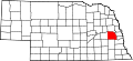
History
Saunders County was established by an 1856 act of the Nebraska Territorial Legislature, and was organized in 1866; [5] [6] its boundaries were redefined in 1858. [7] It was originally named Calhoun County after John Calhoun, surveyor general of Kansas and Nebraska. [8] [9] Other sources contend that it was named for John C. Calhoun of South Carolina. [10] In 1862, during the American Civil War, it was renamed after Nebraska territorial governor Alvin Saunders. [11]
The first town in Saunders County was Ashland, then known as Saline Ford. Settlers continuing west from Nebraska City would often follow the Platte River across the state. To do so, they would have to cross the Salt Creek. A limestone-bottomed section of the creek near Ashland offered the safest opportunity. Permanent settlers occupied the area in the 1850s and the town of Ashland was officially formed in 1866. [12]
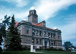
Ashland served as the county seat of government beginning with the first elections in 1867. A courthouse was constructed in 1870. As Saunders County grew, residents realized they wanted a more centrally located seat of government. A vote was held in 1873 and Wahoo was selected to replace Ashland. The new courthouse was built in 1874. That building served the county until 1904 when a new building was constructed. The 1904 courthouse is still in use as of 2025. [13] [14]
Demographics
Historical population| Census | Pop. | Note | %± |
|---|
| 1870 | 4,547 | | — |
|---|
| 1880 | 15,810 | | 247.7% |
|---|
| 1890 | 21,577 | | 36.5% |
|---|
| 1900 | 22,085 | | 2.4% |
|---|
| 1910 | 21,179 | | −4.1% |
|---|
| 1920 | 20,589 | | −2.8% |
|---|
| 1930 | 20,167 | | −2.0% |
|---|
| 1940 | 17,892 | | −11.3% |
|---|
| 1950 | 16,923 | | −5.4% |
|---|
| 1960 | 17,270 | | 2.1% |
|---|
| 1970 | 17,018 | | −1.5% |
|---|
| 1980 | 18,716 | | 10.0% |
|---|
| 1990 | 18,285 | | −2.3% |
|---|
| 2000 | 19,830 | | 8.4% |
|---|
| 2010 | 20,780 | | 4.8% |
|---|
| 2020 | 22,278 | | 7.2% |
|---|
| 2023 (est.) | 23,463 | [1] | 5.3% |
|---|
|
As of the 2020 United States census, [27] there were 22,278 people and 8,789 households. The population density was 29 people per square mile (11 people/km2). There were 10,424 housing units at an average density of 13.7 units per square mile (5.3 units/km2). The racial makeup of the county was 96.7% White, 0.7% Black or African American, 0.5% Native American, 0.5% Asian, 0.00% Pacific Islander, and 1.6% from two or more races. 2.6% of the population were Hispanic or Latino of any race.
As of the 2010 United States census, [27] there were 20,778 people and 8,040 households. The population density was 28 people per square mile (11 people/km2). There were 9,221 housing units at an average density of 12.3 units per square mile (4.7 units/km2). The racial makeup of the county was 97.2% White, 0.3% Black or African American, 0.3% Native American, 0.4% Asian, 0.00% Pacific Islander, 0.7% from other races, and 1.1% from two or more races. 2.0% of the population were Hispanic or Latino of any race.
As of the 2000 United States census, [27] there were 19,830 people, 7,498 households, and 5,443 families in the county. The population density was 26 people per square mile (10 people/km2). There were 8,266 housing units at an average density of 11 units per square mile (4.2 units/km2). The racial makeup of the county was 98.49% White, 0.11% Black or African American, 0.29% Native American, 0.22% Asian, 0.01% Pacific Islander, 0.35% from other races, and 0.55% from two or more races. 1.03% of the population were Hispanic or Latino of any race.
There were 7,498 households, out of which 34.20% had children under the age of 18 living with them, 62.60% were married couples living together, 6.70% had a female householder with no husband present, and 27.40% were non-families. 23.60% of all households were made up of individuals, and 11.90% had someone living alone who was 65 years of age or older. The average household size was 2.61 and the average family size was 3.11.
The county population contained 27.90% under the age of 18, 6.30% from 18 to 24, 27.60% from 25 to 44, 22.90% from 45 to 64, and 15.30% who were 65 years of age or older. The median age was 38 years. For every 100 females there were 99.10 males. For every 100 females age 18 and over, there were 98.10 males.
The median income for a household in the county was $42,173, and the median income for a family was $49,443. Males had a median income of $33,309 versus $22,922 for females. The per capita income for the county was $18,392. About 5.30% of families and 6.60% of the population were below the poverty line, including 7.30% of those under age 18 and 7.00% of those age 65 or over.