Nebraska Highway 66

Last updated

N-66.svg

Nebraska Highway 66
Nebraska Highway 66
N-66 highlighted in red
Route information
Maintained by NDOT
Length83.55 mi [1] (134.46 km)
Western segment
Length21.01 mi [1] (33.81 km)
West endN-14.svg N-14 south of Central City
East endUS 81.svg US 81 south of Stromsburg
Middle segment
Length14.03 mi [1] (22.58 km)
West endN-15.svg N-15 west of Dwight
East endN-79.svg N-79 in Valparaiso
Eastern segment
Length35.34 mi [1] (56.87 km)
West endUS 77.svg US 77 south of Wahoo
Major
junctions
US 6.svg US 6 in Ashland
I-80.svg I-80 southeast of Ashland
N-50.svg N-50 southwest of Louisville
East endMain Street in Louisville
Far eastern segment
Length13.17 mi [1] (21.20 km)
West endWalnut Street in Louisville
East endUS 34.svgUS 75.svg US 34 / US 75 west of Plattsmouth
Location
CountiesWestern segment: Hamilton, Polk
Middle segment: Butler, Saunders
Eastern segment: Saunders, Cass
Far eastern segment: Cass
Highway system
N-65.svg N-65 N-67 N-67.svg

Nebraska Highway 66 is a highway in central and eastern Nebraska. It is a discontinuous highway with four segments heading in a west-to-east direction. The first segment begins at Nebraska Highway 14 south of Central City and ends at U.S. Highway 81 south of Stromsburg. The second segment begins at Nebraska Highway 15 west of Dwight and ends at Nebraska Highway 79 in Valparaiso. The third segment begins at U.S. Highway 77 south of Wahoo and ends at Main Street in Louisville. The fourth and final segment begins at the intersection with Walnut Street and Koop Avenue in Louisville, and ends at U.S. Highway 34 and U.S. Highway 75 west of Plattsmouth.

Contents

Route description

Western segment

Nebraska Highway 66 begins at an intersection with NE 14 south of Central City. It heads eastward through farmland, passing through Hordville and Polk along the way. South of Stromsburg, it meets US 81 where the western segment terminates. The next segment begins about 26 miles (42 km) to the east of this point. [1] [2]

Middle segment

The middle segment of Nebraska Highway 66 begins at NE 15 west of Dwight. It continues in an eastward direction through farmland before ending at NE 79 in Valparaiso. The next segment picks up just over 15 miles (24 km) to the east of Valparaiso. [1] [3]

Eastern segment

The eastern segment of N-66 starts at an intersection with US 77 south of Wahoo. It again continues eastward and to the southeast into farmland, passing near the communities of Ithaca and Memphis. To the southeast, it enters Ashland where the highway will intersect with US 6. Continuing to the southeast, N-66 intersects I-80 at exit 426. The highway continues eastward, passing through South Bend and heading to the southeast. Southwest of Louisville, the route intersects with NE 50 and runs concurrently northward with it for just over a mile. Upon entering Louisville, N-66 splits off to the east. At Main Street near Mill Creek, this segment ends, as there is no bridge crossing over the creek. The highway resumes 0.13 miles (0.21 km) to the east. [1] [4]

Far eastern segment

Still in Louisville, the far eastern segment of N-66 starts at the intersection with Koop Avenue and Walnut Street. It continues eastward, exiting Louisville and entering farmland. Further to the east, the highway intersects with US 34 and US 75 just west of Plattsmouth. At this point, the highway ends. [1] [5]

History

Prior to October 24, 2005, the segment of Nebraska Highway 66 between U.S. Highway 77 south of Wahoo and U.S. Highway 6 in Ashland was designated as Nebraska Highway 63. On that day, this segment was renumbered to the present designation of NE 66. [6]

Major intersections

CountyLocationmi [1] kmDestinationsNotes
Hamilton Overland 0.000.00N-14.svg N-14 (Broadway Street) Aurora, Central City Western terminus
Polk 21.0133.81US 81.svg US 81 (Center Road)Eastern terminus of western segment; road continues as County Road 123
Gap in route
Butler 47.0175.66N-15.svgN SPUR 12C.svg N-15 (Road O) / S-12C west (Road 23) Ulysses, Seward, David City Western terminus of middle segment; road continues as S-12C
51.0082.08N SPUR 12D.svg S-12D north (South Road) Dwight
Saunders Valparaiso 61.0498.23N-79.svg N-79  North Bend, Lincoln Eastern terminus of middle segment; road continues as South Street
Gap in route
76.24122.70US 77.svg US 77  Lincoln, Wahoo Western terminus of eastern segment; former northern terminus of N-63 ; road continues as County Road G
81.17130.63N SPUR 78B.svg S-78B north Ithaca
90.35145.40N SPUR 78C.svg S-78C west (Galena Street) Memphis
Ashland 97.44156.81US 6.svgN-63.svg US 6 (I-80 Alternate Route) to N-63  Lincoln, Omaha N-66 west of this point is former N-63 north; US 6 west is former N-63 south
Cass 101.30163.03I-80.svg I-80  Lincoln, Omaha I-80 exit 426
Louisville 109.89176.85N-50.svg N-50 southWest end of N-50 overlap
111.24179.02N-50.svgN-66.svg N-50 north to N-66 eastEast end of N-50 overlap
111.58179.57Main StreetEastern terminus of eastern segment
Gap in route
111.71179.78N-50.svgN-66.svg Walnut Street to N-50 / N-66Western terminus of far eastern segment
115.27185.51N SPUR 13H.svg S-13H north (114th Street) Cedar Creek
Plattsmouth 124.88200.97US 34.svgUS 75.svgI-29.svg US 34 / US 75 to I-29  Omaha, Nebraska City Eastern terminus; road continues as 8th Avenue (former US 34 east)
1.000 mi = 1.609 km; 1.000 km = 0.621 mi

Related Research Articles

Nebraska Highway 2 State highway in Nebraska, United States

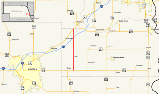
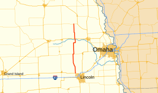
Nebraska Highway 2 is a state highway in Nebraska consisting of two discontinuous segments. The western segment begins at the South Dakota border northwest of Crawford and ends southeast of Grand Island at an intersection with Interstate 80. The eastern segment begins in Lincoln and ends at the Iowa border at Nebraska City. Previously, the two segments were connected via a route shared with U.S. Highway 34 between Grand Island and Lincoln.

Nebraska Highway 4

Nebraska Highway 4 is a highway in Nebraska. The entirety of the route is in Nebraska's southern tier of counties. Beatrice is the only city with over 1,000 in population on the highway. Its western terminus is at an intersection with US 6 and US 34 southwest of Atlanta. Its eastern terminus is at an intersection with US 75 north of Dawson.

Nebraska Highway 63

Nebraska Highway 63 is a north–south highway in eastern Nebraska with a length of 13.93 miles (22.42 km). It is also known throughout Cass County as 238th Street, except in the village of Alvo, where it adopts the name Russell Street. Its southern terminus is at U.S. Highway 34 east of Eagle. Its northern terminus is at U.S. Highway 6 southwest of Ashland.

Nebraska Highway 12

Nebraska Highway 12 is a highway in northern and northeastern Nebraska. It has a western terminus at U.S. Highway 83 in Valentine and an eastern terminus at U.S. Highway 20 west of Jackson. The highway largely lies within 10 miles (16 km) of the South Dakota border its entire length. The highway has been designated the Outlaw Trail Scenic Byway.

Nebraska Highway 64 Highway in Nebraska

Nebraska Highway 64 is a highway in Nebraska. There are two segments to the highway. The western segment lies in Butler County between U.S. Highway 81 and Nebraska Highway 15. The eastern segment goes through Saunders and Douglas counties between U.S. Highway 77 and U.S. Highway 75.

Nebraska Highway 21

Nebraska Highway 21 is a highway in central Nebraska. Its southern terminus is at Nebraska Highway 23 east of Eustis. Its northern terminus is at an intersection with Nebraska Highway 2 and Nebraska Highway 92 in Broken Bow.

Nebraska Highway 47

Nebraska Highway 47 is a highway in Nebraska. It is a highway split into two segments. The southern segment runs for 12 miles (19 km) between Nebraska Highway 89 near Wilsonville and U.S. Highway 6 and U.S. Highway 34 in Cambridge. The northern segment runs for 40 miles (64 km) between Nebraska Highway 23 near Farnam and Nebraska Highway 40 south of Arnold.

Nebraska Highway 57

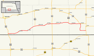
Nebraska Highway 57 (N-57) is a highway in northeastern Nebraska, United States. It is divided into two segments, which combine for a length of 58 miles (93 km). The southern segment begins northeast of Leigh at N-91 and ends at U.S. Highway 275 north of Stanton. The northern segment begins south of Carroll at N-98 and ends north of Hartington at an intersection with N-12.

Nebraska Highway 79

Nebraska Highway 79 is a highway in eastern Nebraska. It is a north–south highway which has a length of 60.28 miles (97.01 km). The southern terminus of Highway 79 is northwest of Lincoln near Lincoln Airport at U.S. Highway 34. The northern terminus of Highway 79 is in Snyder.

Nebraska Highway 59

Nebraska Highway 59 is a highway in northeastern Nebraska. The highway is divided into two segments which combine for a length of 37.49 miles (60.33 km). The western segment of Nebraska Highway 59 has a western terminus at Nebraska Highway 14 west of Creighton and an eastern terminus at U.S. Highway 81 northeast of Magnet. The eastern segment of Highway 59 has its western terminus at Nebraska Highway 57 south of Coleridge and its eastern terminus at U.S. Highway 20 north of Laurel.

Nebraska Highway 84

Nebraska Highway 84 is a highway in the northeastern part of the U.S. state of Nebraska. Its western terminus is at Nebraska Highway 14 in Verdigre. Its eastern terminus is at an intersection with Nebraska Highway 15 east of Hartington.

Nebraska Highway 94

Nebraska Highway 94 is a highway in northeastern Nebraska. It has a western terminus at an intersection with Nebraska Highway 9 and Nebraska Highway 16 in Pender. Its eastern terminus is at U.S. Highway 75 to the northwest of Macy.

Nebraska Highway 98

Nebraska Highway 98 is a highway in the northeastern part of the U.S. state of Nebraska. Its western terminus is at an intersection with Nebraska Highway 13 in Pierce. Its eastern terminus is at an intersection with Nebraska Highway 35 west of Wayne.

Nebraska Highway 89

Nebraska Highway 89 is a highway in southern Nebraska. Its western terminus is at U.S. Highway 83 west of Danbury. Its eastern terminus is at an intersection with U.S. Highway 183 south of Alma.

Nebraska Highway 103

Nebraska Highway 103 is a highway in southeastern Nebraska. It is a discontinuous highway with two segments. The southern segment begins at Nebraska Highway 8 south of Diller and ends at U.S. Highway 136 north of Diller. The northern segment begins at Nebraska Highway 4 east of Plymouth and ends at Interstate 80 north of Pleasant Dale.

Nebraska Highway 121

Nebraska Highway 121 is a highway in northeastern Nebraska. It is a discontinuous highway with three segments:

Nebraska Highway 91

Nebraska Highway 91 is a highway in central and eastern Nebraska. Its western terminus is at an intersection with Nebraska Highway 2 north of Dunning. Its eastern terminus is at an intersection with U.S. Highway 30 and U.S. Highway 75 in Blair.

Nebraska Highway 70

Nebraska Highway 70 is a highway in central Nebraska. Its western terminus is at an intersection with Nebraska Highway 2 and Nebraska Highway 92 east of Broken Bow. Its eastern terminus is at Nebraska Highway 14 in Elgin.

Nebraska Highway 74

Nebraska Highway 74 is a highway in southern Nebraska. Its western terminus is at an intersection with Nebraska Highway 10 in Minden. Its eastern terminus is at an intersection with Nebraska Highway 15 east of Tobias.

U.S. Route 34 in Nebraska Section of U.S. Highway in Nebraska, United States

In the U.S. state of Nebraska, U.S. Highway 34 is a highway which goes between the Colorado border west of Haigler to the Iowa border east of Plattsmouth. Between Culbertson and Hastings, U.S. 34 overlaps U.S. Highway 6. From Grand Island to Lincoln, U.S. 34 has been replaced by Interstate 80 as a high-speed corridor and mostly serves local traffic. On this portion of the highway, U.S. 34 is continuously north of Interstate 80. Within Lincoln, U.S. 34 runs concurrent with all of Interstate 180, and much of it follows O Street.

References

  1. 1 2 3 4 5 6 7 8 9 10 "Nebraska Highway Reference Log Book" (PDF). Nebraska Department of Roads. 2015. pp. 166–168. Retrieved January 1, 2017.
  2. Google (2010-11-09). "overview of Nebraska Highway 66 first segment" (Map). Google Maps . Google. Retrieved 2010-11-09.
  3. Google (2010-11-09). "overview of Nebraska Highway 66 second segment" (Map). Google Maps . Google. Retrieved 2010-11-09.
  4. Google (2010-11-09). "overview of Nebraska Highway 66 third segment" (Map). Google Maps . Google. Retrieved 2010-11-09.
  5. Google (2010-11-09). "overview of Nebraska Highway 66 fourth segment" (Map). Google Maps . Google. Retrieved 2010-11-09.
  6. "The Nebraska Highways Page: Highways 61 to 100". Archived from the original on 2006-12-07. Retrieved 2008-04-07.

Route map:

KML file (edithelp)
    KML is from Wikidata