Ashland, Nebraska

Last updated

Ashland, Nebraska
Ashland, Nebraska 2.jpg
Downtown Ashland: Silver Street
Flag of Ashland, Nebraska.svg
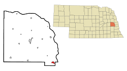
Saunders County Nebraska Incorporated and Unincorporated areas Ashland Highlighted.svg
Location of Ashland, Nebraska
Coordinates: 41°02′26″N96°22′40″W / 41.04056°N 96.37778°W / 41.04056; -96.37778
Country United States
State Nebraska
County Saunders
Area
[1]
  Total1.41 sq mi (3.65 km2)
  Land1.38 sq mi (3.58 km2)
  Water0.03 sq mi (0.07 km2)
Elevation
[2]
1,093 ft (333 m)
Population
 (2020)
  Total3,086
  Density2,231.38/sq mi (861.57/km2)
Time zone UTC-6 (Central (CST))
  Summer (DST) UTC-5 (CDT)
ZIP code
68003
Area code 402
FIPS code 31-02305
GNIS feature ID2394000 [2]
Website http://www.ashland-ne.com/

Ashland is a city in Saunders County, Nebraska, United States. The population was 3,262 at the 2022 census.

Contents

History

Ashland is located at the site of a low-water limestone ledge along the bottom of Salt Creek, an otherwise mud-bottomed stream that was a formidable obstacle for wagon trains on the great westward migrations of the late 1840s and 1850s. The Oxbow Trail, a variant route of the Oregon Trail, ran from Nebraska City (on the Missouri River) to Fort Kearny (on the Platte River), where it joined the main route of the Oregon Trail. The limestone bottom of Salt Creek at Ashland made it an excellent fording site. [3] Ashland was established in 1870 and named after Ashland, the estate of Henry Clay. [4]

Today, Ashland benefits by its proximity to Interstate 80 and the cities of Omaha and Lincoln. While in some respects Ashland is becoming a "bedroom community" of those much larger cities, it retains a rural character. That coherence as a community, and a 30-minute drive to either of the state's economic hubs, has led to a building boom in the late 1990s and the 2000s.

Geography

According to the United States Census Bureau, the city has a total area of 1.13 square miles (2.93 km2), of which 1.10 square miles (2.85 km2) is land and 0.03 square miles (0.08 km2) is water. [5]

Climate

Climate data for Ashland, Nebraska (1991–2020 normals, extremes 1893–2018)
MonthJanFebMarAprMayJunJulAugSepOctNovDecYear
Record high °F (°C)72
(22)
80
(27)
91
(33)
98
(37)
107
(42)
109
(43)
116
(47)
115
(46)
108
(42)
97
(36)
85
(29)
72
(22)
116
(47)
Mean daily maximum °F (°C)32.7
(0.4)
37.7
(3.2)
50.6
(10.3)
62.6
(17.0)
73.3
(22.9)
83.2
(28.4)
87.2
(30.7)
85.2
(29.6)
78.5
(25.8)
65.4
(18.6)
49.8
(9.9)
37.1
(2.8)
61.9
(16.6)
Daily mean °F (°C)23.0
(−5.0)
27.4
(−2.6)
39.1
(3.9)
50.4
(10.2)
61.7
(16.5)
72.3
(22.4)
76.4
(24.7)
74.1
(23.4)
65.9
(18.8)
53.2
(11.8)
38.9
(3.8)
27.7
(−2.4)
50.8
(10.4)
Mean daily minimum °F (°C)13.3
(−10.4)
17.0
(−8.3)
27.6
(−2.4)
38.2
(3.4)
50.1
(10.1)
61.5
(16.4)
65.6
(18.7)
63.0
(17.2)
53.4
(11.9)
40.9
(4.9)
28.1
(−2.2)
18.4
(−7.6)
39.8
(4.3)
Record low °F (°C)−33
(−36)
−33
(−36)
−21
(−29)
3
(−16)
24
(−4)
35
(2)
41
(5)
38
(3)
23
(−5)
3
(−16)
−15
(−26)
−27
(−33)
−33
(−36)
Average precipitation inches (mm)0.85
(22)
0.98
(25)
1.67
(42)
3.18
(81)
5.19
(132)
4.48
(114)
3.68
(93)
3.96
(101)
3.19
(81)
2.40
(61)
1.42
(36)
1.29
(33)
32.29
(820)
Average snowfall inches (cm)5.7
(14)
6.2
(16)
3.2
(8.1)
0.9
(2.3)
0.0
(0.0)
0.0
(0.0)
0.0
(0.0)
0.0
(0.0)
0.0
(0.0)
0.6
(1.5)
0.7
(1.8)
4.8
(12)
22.1
(56)
Average precipitation days (≥ 0.01 in)4.44.65.88.510.99.28.18.16.46.44.44.581.3
Average snowy days (≥ 0.1 in)3.23.41.30.40.00.00.00.00.00.20.82.311.6
Source: NOAA [6] [7]

Demographics

Historical population
CensusPop.Note
1870 653
1880 97849.8%
1890 1,60163.7%
1900 1,477−7.7%
1910 1,379−6.6%
1920 1,72525.1%
1930 1,7863.5%
1940 1,709−4.3%
1950 1,7130.2%
1960 1,98916.1%
1970 2,1769.4%
1980 2,2744.5%
1990 2,136−6.1%
2000 2,2625.9%
2010 2,4538.4%
2020 3,08625.8%
U.S. Decennial Census [8]

2010 census

At the 2010 census there were 2,453 people, 951 households, and 639 families living in the city. The population density was 2,230.0 inhabitants per square mile (861.0/km2). There were 1,060 housing units at an average density of 963.6 units per square mile (372.0 units/km2). The racial makeup of the city was 97.6% White, 0.2% African American, 0.2% Native American, 0.2% Asian, 0.3% from other races, and 1.5% from two or more races. Hispanic or Latino individuals of any race were 2.6%. [9]

Of the 951 households 34.8% had children under the age of 18 living with them, 50.7% were married couples living together, 11.5% had a female householder with no husband present, 5.0% had a male householder with no wife present, and 32.8% were non-families. 26.1% of households were one person and 12.5% were one person aged 65 or older. The average household size was 2.49 and the average family size was 3.00.

The median age was 37 years. 26.1% of residents were under the age of 18; 8.5% were between the ages of 18 and 24; 24.8% were from 25 to 44; 24.7% were from 45 to 64; and 15.9% were 65 or older. The gender makeup of the city was 49.7% male and 50.3% female.

2000 census

At the 2000 census, there were 2,262 people, 877 households, and 591 families living in the city. The population density was 2,130.2 inhabitants per square mile (822.5/km2). There were 930 housing units at an average density of 875.8 units per square mile (338.1 units/km2). The racial makeup of the city was 98.76% White, 0.13% African American, 0.27% Native American, 0.40% Asian, 0.18% from other races, and 0.27% from two or more races. Hispanic or Latino individuals of any race were 1.64% of the population.

Of the 877 households 33.8% had children under the age of 18 living with them, 53.5% were married couples living together, 10.8% had a female householder with no husband present, and 32.6% were non-families. 26.7% of households were one person and 15.4% were one person aged 65 or older. The average household size was 2.47 and the average family size was 3.01.

The age distribution was 25.7% under the age of 18, 7.4% from 18 to 24, 28.3% from 25 to 44, 20.3% from 45 to 64, and 18.2% 65 or older. The median age was 38 years. For every 100 females, there were 88.5 males. For every 100 females age 18 and over, there were 89.0 males.

The median household income was $40,441, and the median family income was $47,428. Males had a median income of $32,339 versus $21,328 for females. The per capita income for the city was $19,072. About 9.3% of families and 9.5% of the population were below the poverty line, including 13.6% of those under age 18 and 9.6% of those age 65 or over.

Business and industry

Employers in the Ashland area include Innovative Laboratory Systems, Linoma Software, Camp Ashland (Nebraska Army National Guard Training Center), and Trade Well Pallet.[ citation needed ]

Notable people

Ashland is the hometown of astronaut Clayton Anderson. [10]

Ashland is the hometown of Jeff Raikes, former chief executive officer of the Bill & Melinda Gates Foundation.

See also

Related Research Articles

<span class="mw-page-title-main">Saunders County, Nebraska</span> County in Nebraska, United States

Saunders County is a county in the U.S. state of Nebraska. As of the 2020 United States Census, the population was 22,278. Its county seat is Wahoo.

<span class="mw-page-title-main">Louisville, Nebraska</span> City in Nebraska, United States

Louisville is a city in northern Cass County, Nebraska, United States. The population was 1,319 at the 2020 census.

<span class="mw-page-title-main">Homer, Nebraska</span> Villages in Dakota County, Nebraska, United States

Homer is a village in Dakota County, Nebraska, United States. It is part of the Sioux City, IA–NE–SD Metropolitan Statistical Area. The population was 549 at the 2010 census.

<span class="mw-page-title-main">Bloomfield, Nebraska</span> City in Nebraska, United States

Bloomfield is a city in Knox County, Nebraska, United States. The population was 1,028 at the 2010 census.

<span class="mw-page-title-main">Grant, Nebraska</span> City in Nebraska, United States

Grant is a city and county seat of Perkins County, Nebraska, United States. The population was 1,165 at the 2010 census.

<span class="mw-page-title-main">Crete, Nebraska</span> City in Saline County, Nebraska, United States

Crete is a city in and the most populous municipality of Saline County, Nebraska, United States. The population was 7,099 at the 2020 census. The city is home to Doane University.

<span class="mw-page-title-main">Gretna, Nebraska</span> City in Sarpy County, Nebraska, United States

Gretna is a city in Sarpy County, Nebraska, United States. The population was 9,071 at the 2022 census.

<span class="mw-page-title-main">Cedar Bluffs, Nebraska</span> Village in Saunders County, Nebraska, United States

Cedar Bluffs is a village in Saunders County, Nebraska, United States. The population was 615 at the 2020 census. Cedar Bluffs was a point on the Mormon, Oregon, and California Trails.

<span class="mw-page-title-main">Ceresco, Nebraska</span> Village in Saunders County, Nebraska, United States

Ceresco is a farming village in Saunders County, Nebraska, United States. The population was 919 at the 2020 census. It is located near U.S. Highway 77, just north of Lincoln, just south of Wahoo, and a short distance southwest of Omaha.

<span class="mw-page-title-main">Colon, Nebraska</span> Village in Saunders County, Nebraska, United States

Colon is a village in Saunders County, Nebraska, United States. The population was 107 at the 2020 census. Amenities include a post office and bank branch. Colon is seven miles north of the county seat Wahoo.

<span class="mw-page-title-main">Ithaca, Nebraska</span> Village in Saunders County, Nebraska, United States

Ithaca is a village in Saunders County, Nebraska, United States. The population was 160 at the 2020 census.

<span class="mw-page-title-main">Leshara, Nebraska</span> Village in Saunders County, Nebraska, United States

Leshara is a village in Saunders County, Nebraska, United States. The population was 108 at the 2020 census.

<span class="mw-page-title-main">Mead, Nebraska</span> Village in Saunders County, Nebraska, United States

Mead is a village in Saunders County, Nebraska, United States. The population was 617 at the 2020 census.

<span class="mw-page-title-main">Memphis, Nebraska</span> Village in Nebraska, United States

Memphis is a village in Saunders County, Nebraska, United States. The population was 109 at the 2020 census.

<span class="mw-page-title-main">Prague, Nebraska</span> Village in Saunders County, Nebraska, United States

Prague is a village in Saunders County, Nebraska, United States. The population was 291 at the 2020 census. It was named after Prague, capital of Bohemia. However, it is pronounced differently, rhyming with "Craig."

<span class="mw-page-title-main">Valparaiso, Nebraska</span> Village in Saunders County, Nebraska, United States

Valparaiso is a village in Saunders County, Nebraska, United States. The population was 595 at the 2020 census.

<span class="mw-page-title-main">Weston, Nebraska</span> Village in Saunder County, Nebraska, United States

Weston is a village in Saunders County, Nebraska, United States. The population was 250 at the 2020 census.

<span class="mw-page-title-main">Yutan, Nebraska</span> City in Saunders County, Nebraska, United States

Yutan is a city in Saunders County, Nebraska, United States.

<span class="mw-page-title-main">Milford, Nebraska</span> City in Seward County, Nebraska, United States

Milford is a city in Seward County, Nebraska, United States. It is part of the Lincoln, Nebraska Metropolitan Statistical Area. The population was 2,155 at the 2020 census.

<span class="mw-page-title-main">Fort Calhoun, Nebraska</span> City in Washington County, Nebraska, United States

Fort Calhoun is a city in Washington County, Nebraska, United States. The population was 1,108 at the 2020 census. The city includes Fort Atkinson, the first fort built west of the Missouri River.

References

  1. "ArcGIS REST Services Directory". United States Census Bureau. Retrieved September 18, 2022.
  2. 1 2 U.S. Geological Survey Geographic Names Information System: Ashland, Nebraska
  3. "Ashland, Saunders County". Center for Advanced Land Management Information Technologies. University of Nebraska. Retrieved August 23, 2014.
  4. Perky, Charles (1915). Past and Present of Saunders County, Nebraska: A Record of Settlement, Organization, Progress and Achievement. S.J. Clarke publishing Company. p. 93.
  5. "US Gazetteer files 2010". United States Census Bureau. Archived from the original on January 25, 2012. Retrieved June 24, 2012.
  6. "NOWData - NOAA Online Weather Data". National Oceanic and Atmospheric Administration. Retrieved April 3, 2024.
  7. "Summary of Monthly Normals 1991-2020". National Oceanic and Atmospheric Administration. Retrieved April 3, 2024.
  8. United States Census Bureau. "Census of Population and Housing" . Retrieved October 19, 2013.
  9. "U.S. Census website". United States Census Bureau . Retrieved June 24, 2012.
  10. "Astronaut Biography: Clayton C. Anderson". National Aeronautics and Space Administration. January 2008.

Additional reading