Ashland Township | |
|---|---|
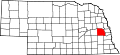
 Location in Saunders County | |
| Coordinates: 41°01′01″N096°24′00″W / 41.01694°N 96.40000°W | |
| Country | United States |
| State | Nebraska |
| County | Saunders |
| Area | |
• Total | 14.62 sq mi (37.86 km2) |
| • Land | 14.47 sq mi (37.48 km2) |
| • Water | 0.15 sq mi (0.39 km2) 1.03% |
| Elevation | 1,102 ft (336 m) |
| Population | |
• Total | 3,180 |
| • Density | 220/sq mi (84.8/km2) |
| ZIP code | 68003 [2] |
| Area codes | 402 and 531 |
| GNIS feature ID | 0837862 |
Ashland Township is one of twenty-four townships in Saunders County, Nebraska, United States. The population was 3,180 at the 2020 census. A 2021 estimate placed the township's population at 3,286. [1]
Contents
Most of the City of Ashland lies within the Township.