Wann, Nebraska | |
|---|---|
 | |
| Coordinates: 41°08′48″N96°21′21″W / 41.14667°N 96.35583°W | |
| Country | United States |
| State | Nebraska |
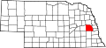
| County | Saunders |
| Area | |
• Total | 1.50 sq mi (3.89 km2) |
| • Land | 1.49 sq mi (3.86 km2) |
| • Water | 0.01 sq mi (0.03 km2) |
| Elevation | 1,083 ft (330 m) |
| Population (2020) | |
• Total | 102 |
| • Density | 68.46/sq mi (26.44/km2) |
| ZIP code | 68003 [3] |
| Area codes | 402 and 531 |
| FIPS code | 31-51350 |
| GNIS feature ID | 2583904 [2] |
Wann is an unincorporated community and census-designated place in Saunders County, Nebraska, United States. [2]