Murdock, Nebraska | |
---|---|
Coordinates: 40°55′34″N96°16′51″W / 40.92611°N 96.28083°W | |
Country | United States |
State | Nebraska |
County | Cass |
Area | |
• Total | 0.13 sq mi (0.33 km2) |
• Land | 0.13 sq mi (0.33 km2) |
• Water | 0.00 sq mi (0.00 km2) |
Elevation | 1,283 ft (391 m) |
Population (2020) | |
• Total | 270 |
• Density | 2,093.02/sq mi (807.01/km2) |
Time zone | UTC-6 (Central (CST)) |
• Summer (DST) | UTC-5 (CDT) |
ZIP code | 68407 |
Area code | 402 |
FIPS code | 31-33320 [3] |
GNIS feature ID | 2399429 [2] |
Website | http://www.MurdockNebraska.com |
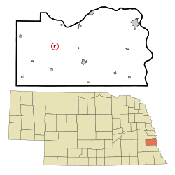
Murdock is a village in Cass County, Nebraska, United States. The population was 270 according to the 2020 census.
Murdock was established circa 1890 when the Chicago, Rock Island and Pacific Railroad was extended to that point. [4] Murdock was named after a Rock Island Railroad official. [5]
According to the United States Census Bureau, the village has a total area of 0.13 square miles (0.34 km2), all land. [6]
Census | Pop. | Note | %± |
---|---|---|---|
1910 | 222 | — | |
1920 | 206 | −7.2% | |
1930 | 233 | 13.1% | |
1940 | 199 | −14.6% | |
1950 | 225 | 13.1% | |
1960 | 247 | 9.8% | |
1970 | 262 | 6.1% | |
1980 | 242 | −7.6% | |
1990 | 267 | 10.3% | |
2000 | 269 | 0.7% | |
2010 | 236 | −12.3% | |
2020 | 270 | 14.4% | |
U.S. Decennial Census [7] |
As of the census [3] of 2000, there were 269 people, 110 households, and 75 families living in the village. The population density was 2,231.5 inhabitants per square mile (861.6/km2). There were 117 housing units at an average density of 970.6 per square mile (374.8/km2). The racial makeup of the village was 98.51% White, 0.37% Native American, 0.37% Asian, and 0.74% from two or more races.
There were 110 households, out of which 30.9% had children under the age of 18 living with them, 57.3% were married couples living together, 8.2% had a female householder with no husband present, and 31.8% were non-families. 28.2% of all households were made up of individuals, and 18.2% had someone living alone who was 65 years of age or older. The average household size was 2.45 and the average family size was 3.05.
In the village, the population was spread out, with 28.3% under the age of 18, 5.6% from 18 to 24, 25.3% from 25 to 44, 24.9% from 45 to 64, and 16.0% who were 65 years of age or older. The median age was 39 years. For every 100 females, there were 94.9 males. For every 100 females age 18 and over, there were 82.1 males.
As of 2000 the median income for a household in the village was $35,781, and the median income for a family was $45,357. Males had a median income of $36,875 versus $22,031 for females. The per capita income for the village was $16,766. About 2.3% of families and 2.5% of the population were below the poverty line, including 3.8% of those under the age of eighteen and none of those 65 or over.
As of the census [8] of 2010, there were 236 people, 109 households, and 66 families living in the village. The population density was 1,815.4 inhabitants per square mile (700.9/km2). There were 118 housing units at an average density of 907.7 per square mile (350.5/km2). The racial makeup of the village was 99.2% White and 0.8% Native American. Hispanic or Latino of any race were 1.3% of the population.
There were 109 households, of which 23.9% had children under the age of 18 living with them, 51.4% were married couples living together, 7.3% had a female householder with no husband present, 1.8% had a male householder with no wife present, and 39.4% were non-families. 32.1% of all households were made up of individuals, and 13.8% had someone living alone who was 65 years of age or older. The average household size was 2.17 and the average family size was 2.73.
The median age in the village was 44 years. 18.2% of residents were under the age of 18; 6.3% were between the ages of 18 and 24; 25.9% were from 25 to 44; 32.6% were from 45 to 64; and 16.9% were 65 years of age or older. The gender makeup of the village was 52.1% male and 47.9% female.
Murdock is a rural town in Swift County, Minnesota, United States. The population was 306 at the 2020 census. The city is part of the Kerhoven-Murdock-Sunburg (KMS) school district. Murdock has Kerkhoven-Murdock-Sunburg Elementary School which is for grades PreK-5.
Leslie is a village in west central Franklin County, Missouri, United States. The population was 171 at the 2010 census.
Country Life Acres is a village in St. Louis County, Missouri, United States. The population was 74 at the 2010 census.
Mackenzie is an unincorporated community in St. Louis County, Missouri, United States. The population was 134 at the 2010 census.
Westwood is a village in west St. Louis County, Missouri, United States. The population was 316 at the 2020 census.
Wilbur Park is a village in St. Louis County, Missouri, United States. The population was 439 at the 2020 census.
Elmwood is a village in southeast Cass County, Nebraska, United States. The population was 654 at the 2020 census.
Uplands Park is a village in St. Louis County, Missouri, United States. The population was 445 at the 2010 census. The village is one of many small majority black communities located in the Natural Bridge corridor of mid-St. Louis County, characterized by small homes on small lots.
Cuyahoga Heights is a village in Cuyahoga County, Ohio, United States. The population was 573 at the 2020 census.
Kirkersville is a village in Licking County, Ohio, United States, along the South Fork of the Licking River. The population was 471 at the 2020 census.
Darbyville is a village in Pickaway County, Ohio, United States. The population was 222 at the 2010 census.
Windsor Heights is a village in Brooke County, West Virginia, United States. It is part of the Wheeling, West Virginia Metropolitan Statistical Area. The population was 423 at the 2010 census. Grace Davis was the mayor as of June, 2017.
Bethlehem is a village in Ohio County, West Virginia, United States. It is part of the Wheeling, West Virginia Metropolitan Statistical Area. The population was 2,499 at the 2010 census.
Clearview is a village in Ohio County, West Virginia, United States. It is part of the Wheeling, West Virginia Metropolitan Statistical Area. The population was 565 at the 2010 census.
Bellevue is a village in Brown County, Wisconsin. It was a town until incorporating as a village on February 14, 2003. The population was 14,570 at the time of the 2010 census. Bellevue is part of the Green Bay metropolitan area. Bellevue sits around 4.34 miles (6.99km) east from central Green Bay.
Friesland is a village in Columbia County, Wisconsin, United States. The population was 320 at the 2020 census. It is part of the Madison Metropolitan Statistical Area.
Kekoskee is a village in Dodge County, Wisconsin, United States. The population was 161 at the 2010 census.
Bay City is a village on the Mississippi River in Pierce County, Wisconsin, United States. The population was 500 at the 2010 census.
Hubbardston is a village in the U.S. state of Michigan. It is mostly in North Plains Township in Ionia County, and partially in Lebanon Township in Clinton County. Its population was 395 at the 2010 census.
Verona is a village in Montgomery and Preble counties in the U.S. state of Ohio. The population was 403 at the 2020 census. It is part of the Dayton Metropolitan Statistical Area.