Alvo, Nebraska

Last updated

Alvo, Nebraska
Alvo, Nebraska downtown (1).JPG
Downtown Alvo
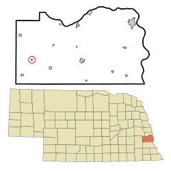
Cass County Nebraska Incorporated and Unincorporated areas Alvo Highlighted.svg
Location of Alvo, Nebraska
Coordinates: 40°52′20″N96°23′11″W / 40.87222°N 96.38639°W / 40.87222; -96.38639
Country United States
State Nebraska
County Cass
Area
[1]
  Total0.10 sq mi (0.26 km2)
  Land0.10 sq mi (0.26 km2)
  Water0.00 sq mi (0.00 km2)
Elevation
[2]
1,339 ft (408 m)
Population
 (2020)
  Total115
  Density1,150.00/sq mi (443.84/km2)
Time zone UTC-6 (Central (CST))
  Summer (DST) UTC-5 (CDT)
ZIP code
68304
Area code 402
FIPS code 31-01150 [3]
GNIS feature ID2397951 [2]
Website http://www.AlvoNebraska.com

Alvo is a village in Cass County, Nebraska, United States. The population was 115 at the 2020 census.

Contents

History

Alvo was established circa 1892 when the Chicago, Rock Island and Pacific Railroad was extended to that point. [4] According to tradition, the community was named after Alvo, the first white child born in the new settlement, [5] who reportedly was the daughter of a railroad official. [6]

Geography

Alvo is located at 40°52′20″N96°23′8″W / 40.87222°N 96.38556°W / 40.87222; -96.38556 (40.872257, -96.385574). [7]

According to the United States Census Bureau, the village has a total area of 0.10 square miles (0.26 km2), all land. [8]

Demographics

Historical population
CensusPop.Note
1920 208
1930 163−21.6%
1940 21531.9%
1950 190−11.6%
1960 159−16.3%
1970 151−5.0%
1980 144−4.6%
1990 16413.9%
2000 142−13.4%
2010 132−7.0%
2020 115−12.9%
U.S. Decennial Census [9]

2010 census

As of the census [10] of 2010, there were 132 people, 52 households, and 37 families living in the village. The population density was 1,320.0 inhabitants per square mile (509.7/km2). There were 60 housing units at an average density of 600.0 per square mile (231.7/km2). The racial makeup of the village was 100.0% White.

There were 52 households, of which 42.3% had children under the age of 18 living with them, 51.9% were married couples living together, 11.5% had a female householder with no husband present, 7.7% had a male householder with no wife present, and 28.8% were non-families. 25.0% of all households were made up of individuals, and 5.7% had someone living alone who was 65 years of age or older. The average household size was 2.54 and the average family size was 3.00.

The median age in the village was 30.7 years. 29.5% of residents were under the age of 18; 6.1% were between the ages of 18 and 24; 28% were from 25 to 44; 26.5% were from 45 to 64; and 9.8% were 65 years of age or older. The gender makeup of the village was 49.2% male and 50.8% female.

2000 census

As of the census [3] of 2000, there were 142 people, 58 households, and 41 families living in the village. The population density was 1,418.7 inhabitants per square mile (547.8/km2). There were 63 housing units at an average density of 629.4 per square mile (243.0/km2). The racial makeup of the village was 97.89% White, and 2.11% from two or more races.

There were 58 households, out of which 32.8% had children under the age of 18 living with them, 63.8% were married couples living together, 5.2% had a female householder with no husband present, and 27.6% were non-families. 25.9% of all households were made up of individuals, and 15.5% had someone living alone who was 65 years of age or older. The average household size was 2.45 and the average family size was 2.90.

In the village, the population was spread out, with 24.6% under the age of 18, 4.2% from 18 to 24, 34.5% from 25 to 44, 22.5% from 45 to 64, and 14.1% who were 65 years of age or older. The median age was 38 years. For every 100 females, there were 105.8 males. For every 100 females age 18 and over, there were 94.5 males.

As of 2000 the median income for a household in the village was $36,250, and the median income for a family was $50,208. Males had a median income of $38,750 versus $22,188 for females. The per capita income for the village was $15,069. There were 16.3% of families and 16.8% of the population living below the poverty line, including 23.5% of under eighteens and 13.6% of those over 64.

Education

It is in the Waverly School District 145. [11]

Related Research Articles

<span class="mw-page-title-main">Cass County, Nebraska</span> County in Nebraska, United States

Cass County is a county in the U.S. state of Nebraska. As of the 2020 United States Census, the population was 26,598. Its county seat and largest city is Plattsmouth. The county was formed in 1855, and was named for General Lewis Cass.

<span class="mw-page-title-main">Ayr, Nebraska</span> Village in Adams County, Nebraska, United States.

Ayr is a village in Adams County, Nebraska, United States. The population was 94 at the 2010 census. It is part of the Hastings, Nebraska Micropolitan Statistical Area.

<span class="mw-page-title-main">Brunswick, Nebraska</span> Village in Antalope County, Nebraska, United States

Brunswick is a village in Antelope County, Nebraska, United States. The population was 138 at the 2010 census.

<span class="mw-page-title-main">Riverdale, Nebraska</span> Village in Nebraska, United States

Riverdale is a village in Buffalo County, in the state of Nebraska, in the Midwestern United States. It is part of the Kearney, Nebraska Micropolitan Statistical Area. The population was 182 at the 2010 census.

<span class="mw-page-title-main">Avoca, Nebraska</span> Village in Nebraska, United States

Avoca is a village in Cass County, Nebraska, United States. The population was 178 at the 2020 census.

<span class="mw-page-title-main">Cedar Creek, Nebraska</span> Village in Nebraska, United States

Cedar Creek is a village in Cass County, Nebraska, United States. The population was 465 at the 2020 census.

<span class="mw-page-title-main">Eagle, Nebraska</span> Village in Nebraska, United States

Eagle is a village in southwest Cass County, Nebraska, United States. As of the 2020 census, the village population was 1,065.

<span class="mw-page-title-main">Elmwood, Nebraska</span> Village in Nebraska, United States

Elmwood is a village in southeast Cass County, Nebraska, United States. The population was 654 at the 2020 census.

<span class="mw-page-title-main">Greenwood, Nebraska</span> Village in Nebraska, United States

Greenwood is a village in northwest Cass County, Nebraska, United States. The population was 595 at the 2020 census.

<span class="mw-page-title-main">Louisville, Nebraska</span> City in Nebraska, United States

Louisville is a city in northern Cass County, Nebraska, United States. The population was 1,319 at the 2020 census.

<span class="mw-page-title-main">Manley, Nebraska</span> Village in Nebraska, United States

Manley is a village in Cass County, Nebraska, United States. The population was 167 at the 2020 census.

<span class="mw-page-title-main">Murdock, Nebraska</span> Village in Nebraska, United States

Murdock is a village in Cass County, Nebraska, United States. The population was 270 according to the 2020 census.

<span class="mw-page-title-main">Murray, Nebraska</span> Village in Nebraska, United States

Murray is a village in Cass County, Nebraska, United States. The population was 480 at the 2020 census.

<span class="mw-page-title-main">Nehawka, Nebraska</span> Village in Nebraska, United States

Nehawka is a village in southeast Cass County, Nebraska, United States. The population was 173 at the 2020 census.

<span class="mw-page-title-main">South Bend, Nebraska</span> Village in Nebraska, United States

South Bend is a village in Cass County, Nebraska, United States. The population was 92 at the 2020 census. The main landmark is a pedestrian bridge across the Platte River which leads to Schramm Park State Recreation Area. It was built in 2004 on the pillars of the abandoned Rock Island Railroad bridge. Thirty-five trains a day—most of them coal trains—still pass through the area on the BNSF Railway main.

<span class="mw-page-title-main">Union, Nebraska</span> Village in Nebraska, United States

Union is a village in southeast Cass County, Nebraska, United States. The population was 195 at the 2020 census.

<span class="mw-page-title-main">Gilead, Nebraska</span> Village in Thayer County, Nebraska, United States

Gilead is a village in Thayer County, Nebraska, United States. The population was 32 at the 2020 census.

Reiffton is a census-designated place (CDP) in Exeter Township, Berks County, Pennsylvania, United States. The population was 4,178 at the 2010 census.

<span class="mw-page-title-main">Greenwood Township, Clearfield County, Pennsylvania</span> Township in Pennsylvania, United States

Greenwood Township is a township in Clearfield County, Pennsylvania, United States. The township has a population of 362 people, according to the 2020 United States census. Between Mahaffey and Grampian on U.S. Route 219, Greenwood Township contains the villages of Curry Run and Bells Landing. The West Branch of the Susquehanna River passes through it, along with several abandoned and presently used railroad grades.

<span class="mw-page-title-main">Paradise Township, York County, Pennsylvania</span> Township in Pennsylvania, United States

References

  1. "ArcGIS REST Services Directory". United States Census Bureau. Retrieved September 18, 2022.
  2. 1 2 U.S. Geological Survey Geographic Names Information System: Alvo, Nebraska
  3. 1 2 "U.S. Census website". United States Census Bureau . Retrieved January 31, 2008.
  4. "Alvo, Cass County". Center for Advanced Land Management Information Technologies. University of Nebraska. Retrieved July 31, 2014.
  5. "Cass County History". Cass County. Archived from the original on April 2, 2016. Retrieved March 24, 2018.
  6. "History". Cass County, Nebraska. Archived from the original on July 30, 2017. Retrieved March 24, 2018.
  7. "US Gazetteer files: 2010, 2000, and 1990". United States Census Bureau. February 12, 2011. Retrieved April 23, 2011.
  8. "US Gazetteer files 2010". United States Census Bureau. Archived from the original on January 25, 2012. Retrieved June 24, 2012.
  9. "Census of Population and Housing". Census.gov. Retrieved June 4, 2015.
  10. "U.S. Census website". United States Census Bureau . Retrieved June 24, 2012.
  11. "2020 CENSUS - SCHOOL DISTRICT REFERENCE MAP: Cass County, NE" (PDF). U.S. Census Bureau . Retrieved November 27, 2022.