   Standard route shields | |
| Highway names | |
|---|---|
| Interstates | Interstate X (I-X) |
| US Highways | U.S. Route X (US-X) |
| State | Highway X (N-X) |
| Link: | Link L-XY (L-XY) |
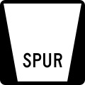
| Spur: | Spur S-XY (S-XY) |
| Recreation Road: | Recreation Road R-XY (R-XY) |
| System links | |
Nebraska Connecting Link, Nebraska Spur, and Nebraska Recreation Road highways are a secondary part of the Nebraska highway system. They connect small towns and state parks to the primary Nebraska highway system. All of these highways are maintained by the Nebraska Department of Transportation.
Contents
A connecting link, or simply a link, highway connects two primary highways. A spur highway is a highway which goes from a primary highway to a city or state park not on any other highway. A recreation road is a road in a state park, which is designated as such by the Nebraska Game and Parks Commission, though maintained by NDOT.
Highways are generally marked in the format of S-x-Y or L-x-Y, where S or L indicates whether it is a spur or a link, x is the county the highway is in, with ranking in alphabetical order (1 is Adams County, while 93 is York County), and Y is the letter which "numbers" the highway. Recreation Roads are typically unsigned. [1]