Bushnell, Nebraska

Last updated

Bushnell, Nebraska
Bushnell, Nebraska from S 2.JPG
Bushnell, looking north along Birch Street
Kimball County Nebraska Incorporated and Unincorporated areas Bushnell Highlighted.svg
Location of Bushnell, Nebraska
Coordinates: 41°13′58″N103°53′28″W / 41.23278°N 103.89111°W / 41.23278; -103.89111
Country United States
State Nebraska
County Kimball
Area
[1]
  Total0.23 sq mi (0.59 km2)
  Land0.23 sq mi (0.59 km2)
  Water0.00 sq mi (0.00 km2)
Elevation
[2]
4,869 ft (1,484 m)
Population
 (2020)
  Total115
  Density504.39/sq mi (194.46/km2)
Time zone UTC-7 (Mountain (MST))
  Summer (DST) UTC-6 (MDT)
ZIP code
69128
Area code 308
FIPS code 31-07415
GNIS feature ID2397510 [2]

Bushnell is a village in Kimball County, Nebraska, United States. The population was 115 at the 2020 census.

Contents

Geography

According to the United States Census Bureau, the village has a total area of 0.23 square miles (0.60 km2), all land. [3]

Climate

Bushnell has a cold semi-arid climate (Köppen BSk), bordering on a dry-winter humid continental climate (Köppen Dwb).

Climate data for Bushnell 15S, Nebraska, 1991–2020 normals, 2002-2023 extremes: 5170ft (1576m)
MonthJanFebMarAprMayJunJulAugSepOctNovDecYear
Record high °F (°C)70
(21)
71
(22)
78
(26)
86
(30)
96
(36)
101
(38)
104
(40)
100
(38)
97
(36)
85
(29)
77
(25)
72
(22)
104
(40)
Mean maximum °F (°C)58.1
(14.5)
61.1
(16.2)
71.4
(21.9)
78.3
(25.7)
85.0
(29.4)
92.8
(33.8)
96.9
(36.1)
95.3
(35.2)
91.4
(33.0)
80.7
(27.1)
71.2
(21.8)
60.8
(16.0)
97.6
(36.4)
Mean daily maximum °F (°C)38.3
(3.5)
39.2
(4.0)
48.9
(9.4)
55.8
(13.2)
64.8
(18.2)
76.7
(24.8)
84.3
(29.1)
82.7
(28.2)
74.3
(23.5)
59.5
(15.3)
47.2
(8.4)
37.7
(3.2)
59.1
(15.1)
Daily mean °F (°C)24.8
(−4.0)
25.7
(−3.5)
33.9
(1.1)
40.8
(4.9)
50.4
(10.2)
60.9
(16.1)
67.8
(19.9)
66.2
(19.0)
57.7
(14.3)
43.9
(6.6)
32.6
(0.3)
24.4
(−4.2)
44.1
(6.7)
Mean daily minimum °F (°C)11.2
(−11.6)
12.1
(−11.1)
18.8
(−7.3)
25.8
(−3.4)
35.9
(2.2)
45.1
(7.3)
51.2
(10.7)
49.6
(9.8)
41.1
(5.1)
28.2
(−2.1)
18.0
(−7.8)
11.0
(−11.7)
29.0
(−1.7)
Mean minimum °F (°C)−11.0
(−23.9)
−11.9
(−24.4)
1.6
(−16.9)
11.9
(−11.2)
22.3
(−5.4)
35.3
(1.8)
44.0
(6.7)
40.9
(4.9)
29.6
(−1.3)
12.3
(−10.9)
−0.5
(−18.1)
−10.6
(−23.7)
−18.7
(−28.2)
Record low °F (°C)−20
(−29)
−30
(−34)
−18
(−28)
−6
(−21)
11
(−12)
28
(−2)
36
(2)
31
(−1)
23
(−5)
−4
(−20)
−24
(−31)
−24
(−31)
−30
(−34)
Average precipitation inches (mm)0.26
(6.6)
0.39
(9.9)
0.88
(22)
1.69
(43)
2.68
(68)
2.52
(64)
2.49
(63)
2.22
(56)
1.39
(35)
1.20
(30)
0.52
(13)
0.46
(12)
16.7
(422.5)
Average snowfall inches (cm)4.10
(10.4)
8.70
(22.1)
8.70
(22.1)
8.20
(20.8)
2.70
(6.9)
0.00
(0.00)
0.00
(0.00)
0.00
(0.00)
0.20
(0.51)
3.90
(9.9)
6.30
(16.0)
8.80
(22.4)
51.6
(131.11)
Average precipitation days (≥ 0.01 in)3.75.55.89.211.79.79.98.46.76.14.24.785.6
Average snowy days (≥ 0.1 in)3.66.14.74.41.30.10.00.00.21.73.94.730.7
Source 1: NOAA [4]
Source 2: XMACIS2 (temp records & monthly max/mins) [5]

History

Bushnell was founded in 1867. [6] The village is named after Cornelius Scranton Bushnell, a major figure in the development of the ironclads during the Civil War. [7] [8]

Demographics

Historical population
CensusPop.Note
1920 321
1930 3416.2%
1940 252−26.1%
1950 225−10.7%
1960 26618.2%
1970 211−20.7%
1980 187−11.4%
1990 119−36.4%
2000 16236.1%
2010 124−23.5%
2020 115−7.3%
U.S. Decennial Census [9]
2012 Estimate [10]

2010 census

As of the census [11] of 2010, there were 124 people, 60 households, and 39 families residing in the village. The population density was 539.1 inhabitants per square mile (208.1/km2). There were 88 housing units at an average density of 382.6 per square mile (147.7/km2). The racial makeup of the village was 96.8% White, 0.8% African American, and 2.4% from two or more races. Hispanic or Latino of any race were 3.2% of the population.

There were 60 households, of which 16.7% had children under the age of 18 living with them, 56.7% were married couples living together, 3.3% had a female householder with no husband present, 5.0% had a male householder with no wife present, and 35.0% were non-families. 31.7% of all households were made up of individuals, and 18.3% had someone living alone who was 65 years of age or older. The average household size was 2.07 and the average family size was 2.56.

The median age in the village was 54.5 years. 12.9% of residents were under the age of 18; 3.9% were between the ages of 18 and 24; 13.6% were from 25 to 44; 39.6% were from 45 to 64; and 29.8% were 65 years of age or older. The gender makeup of the village was 46.8% male and 53.2% female.

2000 census

As of the census of 2000, there were 162 people, 70 households, and 44 families residing in the village. The population density was 769.7 inhabitants per square mile (297.2/km2). There were 86 housing units at an average density of 408.6 per square mile (157.8/km2). The racial makeup of the village was 99.38% White and 0.62% Pacific Islander. Hispanic or Latino of any race were 6.79% of the population.

There were 70 households, out of which 20.0% had children under the age of 18 living with them, 61.4% were married couples living together, 1.4% had a female householder with no husband present, and 37.1% were non-families. 28.6% of all households were made up of individuals, and 14.3% had someone living alone who was 65 years of age or older. The average household size was 2.31 and the average family size was 2.91.

In the village, the population was spread out, with 21.6% under the age of 18, 5.6% from 18 to 24, 18.5% from 25 to 44, 30.9% from 45 to 64, and 23.5% who were 65 years of age or older. The median age was 48 years. For every 100 females, there were 97.6 males. For every 100 females age 18 and over, there were 108.2 males.

As of 2000 the median income for a household in the village was $26,750, and the median income for a family was $30,750. Males had a median income of $26,250 versus $16,406 for females. The per capita income for the village was $13,024. About 8.5% of families and 7.2% of the population were below the poverty line, including none of those under the age of eighteen and 12.8% of those 65 or over.

Culture

The annual Bushnell Day parade and festivities are held on the third Saturday in August.

Notable person

See also

Related Research Articles

<span class="mw-page-title-main">Holstein, Nebraska</span> Village in Adams County, Nebraska, United States

Holstein is a village in Adams County, Nebraska, United States. The population was 188 at the 2020 census. It is part of the Hastings, Nebraska Micropolitan Statistical Area.

<span class="mw-page-title-main">Avoca, Nebraska</span> Village in Nebraska, United States

Avoca is a village in Cass County, Nebraska, United States. The population was 178 at the 2020 census.

<span class="mw-page-title-main">Cedar Creek, Nebraska</span> Village in Nebraska, United States

Cedar Creek is a village in Cass County, Nebraska, United States. The population was 465 at the 2020 census.

<span class="mw-page-title-main">Eagle, Nebraska</span> Village in Nebraska, United States

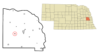
Eagle is a village in southwest Cass County, Nebraska, United States. As of the 2020 census, the village population was 1,065.

<span class="mw-page-title-main">Elmwood, Nebraska</span> Village in Nebraska, United States

Elmwood is a village in southeast Cass County, Nebraska, United States. The population was 654 at the 2020 census.

<span class="mw-page-title-main">Manley, Nebraska</span> Village in Nebraska, United States

Manley is a village in Cass County, Nebraska, United States. The population was 167 at the 2020 census.

<span class="mw-page-title-main">Murray, Nebraska</span> Village in Nebraska, United States

Murray is a village in Cass County, Nebraska, United States. The population was 480 at the 2020 census.

<span class="mw-page-title-main">Boys Town, Nebraska</span> Village in Douglas County, Nebraska, United States

Boys Town is a village in Douglas County, Nebraska, United States. The population was 410 at the 2020 census. Boys Town is an enclave and a suburb of Omaha.

<span class="mw-page-title-main">Waterloo, Nebraska</span> Village in Douglas County, Nebraska, United States

Waterloo is a village in Douglas County, Nebraska, United States. The population was 935 at the 2020 census.

<span class="mw-page-title-main">Page, Nebraska</span> Village in Holt County, Nebraska, United States

Page is a village in Holt County, Nebraska, United States. The population was 166 at the 2010 census.

<span class="mw-page-title-main">Stuart, Nebraska</span> Village in Nebraska, United States

Stuart is a village in Holt County, Nebraska, United States. The population was 590 at the 2010 census.

<span class="mw-page-title-main">Center, Nebraska</span> Village in and county seat of Knox County, Nebraska, United States

Center is a village in, and county seat of, Knox County, Nebraska, United States. The population was 73 at the 2020 census.

<span class="mw-page-title-main">Stapleton, Nebraska</span> Village in and county seat of Logan County, Nebraska, United States

Stapleton is a village in and the county seat of Logan County, Nebraska, United States. The population was 267 at the 2020 census.

<span class="mw-page-title-main">Malmo, Nebraska</span> Village in Saunders County, Nebraska, United States

Malmo is a village in Saunders County, Nebraska, United States. The population was 94 at the 2020 census.

<span class="mw-page-title-main">Memphis, Nebraska</span> Village in Nebraska, United States

Memphis is a village in Saunders County, Nebraska, United States. The population was 109 at the 2020 census.

<span class="mw-page-title-main">Morse Bluff, Nebraska</span> Village in Saunders County, Nebraska, United States

Morse Bluff is a village in Saunders County, Nebraska, United States. The population was 117 at the 2020 census.

<span class="mw-page-title-main">Weston, Nebraska</span> Village in Saunder County, Nebraska, United States

Weston is a village in Saunders County, Nebraska, United States. The population was 250 at the 2020 census.

<span class="mw-page-title-main">Herman, Nebraska</span> Village in Washington County, Nebraska, United States

Herman is a village in Washington County, Nebraska, United States. The population was 268 at the 2010 census.

<span class="mw-page-title-main">Washington, Nebraska</span> Village in Washington County, Nebraska, United States

Washington is a village in Washington County, Nebraska, United States. The population was 150 at the 2010 census.

<span class="mw-page-title-main">Bartlett, Nebraska</span> Village in and county seat of Wheeler County, Nebraska, United States

Bartlett is a village in, and the county seat of, Wheeler County, Nebraska, United States. The population was 117 at the 2010 census.

References

  1. "ArcGIS REST Services Directory". United States Census Bureau. Retrieved September 18, 2022.
  2. 1 2 U.S. Geological Survey Geographic Names Information System: Bushnell, Nebraska
  3. "US Gazetteer files 2010". United States Census Bureau. Archived from the original on January 12, 2012. Retrieved 2012-06-24.
  4. "Bushnell 15S, Nebraska 1991-2020 Monthly Normals" . Retrieved January 15, 2024.
  5. "xmACIS". National Oceanic and Atmospheric Administration. Retrieved January 15, 2024.
  6. "History of Bushnell". Village of Bushnell. Archived from the original on June 8, 2013. Retrieved September 18, 2012.
  7. Beebe, Lucius (1959). Mansions on rails; the folklore of the private railway car. Howell-North. p. 33. OCLC   1424800.
  8. Exploring Nebraska Highways: Trip Trivia. Exploring America's Highway. 2007. p. 58. ISBN   978-0-9744358-7-9.
  9. United States Census Bureau. "Census of Population and Housing" . Retrieved October 19, 2013.
  10. "Annual Estimates of the Resident Population: April 1, 2010 to July 1, 2012". Archived from the original on June 2, 2013. Retrieved October 19, 2013.
  11. "U.S. Census website". United States Census Bureau . Retrieved June 24, 2012.

Commons-logo.svg Media related to Bushnell, Nebraska at Wikimedia Commons