Douglas, Nebraska

Last updated
Douglas, Nebraska
Douglas, NE.jpg
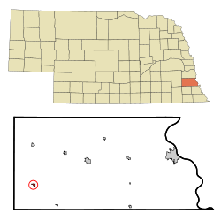
Otoe County Nebraska Incorporated and Unincorporated areas Douglas Highlighted.svg
Location of Douglas, Nebraska
Coordinates: 40°35′35″N96°23′18″W / 40.59306°N 96.38833°W / 40.59306; -96.38833
Country United States
State Nebraska
County Otoe
Area
[1]
  Total0.22 sq mi (0.57 km2)
  Land0.22 sq mi (0.57 km2)
  Water0.00 sq mi (0.00 km2)
Elevation
[2]
1,250 ft (380 m)
Population
 (2020)
  Total166
  Density754.55/sq mi (291.92/km2)
Time zone UTC-6 (Central (CST))
  Summer (DST) UTC-5 (CDT)
ZIP code
68344
Area code 402
FIPS code 31-13505 [3]
GNIS feature ID2398742 [2]
Website https://www.villageofdouglas.com/

Douglas is a village in southwest Otoe County, Nebraska, United States. The population was 166 at the 2020 census.

Contents

History

Douglas was platted c.1888. [4] Douglas was the maiden name of the wife of the original owner of the town site. [5]

Geography

According to the United States Census Bureau, the village has a total area of 0.22 square miles (0.57 km2), all land. [6]

Demographics

Historical population
CensusPop.Note
1900 253
1910 30520.6%
1920 242−20.7%
1930 233−3.7%
1940 2340.4%
1950 213−9.0%
1960 197−7.5%
1970 175−11.2%
1980 20718.3%
1990 199−3.9%
2000 23116.1%
2010 173−25.1%
2020 166−4.0%
U.S. Decennial Census [7]

2010 census

As of the census [8] of 2010, there were 173 people, 79 households, and 46 families living in the village. The population density was 786.4 inhabitants per square mile (303.6/km2). There were 102 housing units at an average density of 463.6 per square mile (179.0/km2). The racial makeup of the village was 98.3% White, 1.2% African American, and 0.6% from two or more races. Hispanic or Latino of any race were 0.6% of the population.

There were 79 households, of which 26.6% had children under the age of 18 living with them, 46.8% were married couples living together, 5.1% had a female householder with no husband present, 6.3% had a male householder with no wife present, and 41.8% were non-families. 32.9% of all households were made up of individuals, and 10.1% had someone living alone who was 65 years of age or older. The average household size was 2.19 and the average family size was 2.83.

The median age in the village was 44.5 years. 21.4% of residents were under the age of 18; 6.3% were between the ages of 18 and 24; 22.6% were from 25 to 44; 39.9% were from 45 to 64; and 9.8% were 65 years of age or older. The gender makeup of the village was 49.1% male and 50.9% female.

2000 census

As of the census [3] of 2000, there were 231 people, 91 households, and 58 families living in the village. The population density was 1,038.7 inhabitants per square mile (401.0/km2). There were 96 housing units at an average density of 431.7 per square mile (166.7/km2). The racial makeup of the village was 97.84% White, 1.30% African American, and 0.87% from two or more races.

There were 91 households, out of which 29.7% had children under the age of 18 living with them, 56.0% were married couples living together, 4.4% had a female householder with no husband present, and 35.2% were non-families. 28.6% of all households were made up of individuals, and 12.1% had someone living alone who was 65 years of age or older. The average household size was 2.54 and the average family size was 3.24.

In the village, the population was spread out, with 26.8% under the age of 18, 7.8% from 18 to 24, 32.0% from 25 to 44, 23.4% from 45 to 64, and 10.0% who were 65 years of age or older. The median age was 38 years. For every 100 females, there were 97.4 males. For every 100 females age 18 and over, there were 108.6 males.

As of 2000 the median income for a household in the village was $33,594, and the median income for a family was $38,889. Males had a median income of $28,125 versus $20,938 for females. The per capita income for the village was $15,174. About 6.9% of families and 14.1% of the population were below the poverty line, including 30.2% of those under the age of eighteen and 18.2% of those 65 or over.

Highways

Related Research Articles

<span class="mw-page-title-main">Otoe County, Nebraska</span> County in Nebraska, United States

Otoe County is a county in the U.S. state of Nebraska. As of the 2010 United States Census, the population was 15,740. Its county seat is Nebraska City. The county was formed in 1854, and was named tor the Otoe Indian tribe.

<span class="mw-page-title-main">Greenwood, Nebraska</span> Village in Nebraska, United States

Greenwood is a village in northwest Cass County, Nebraska, United States. The population was 595 at the 2020 census.

<span class="mw-page-title-main">Manley, Nebraska</span> Village in Nebraska, United States

Manley is a village in Cass County, Nebraska, United States. The population was 167 at the 2020 census.

<span class="mw-page-title-main">Murray, Nebraska</span> Village in Nebraska, United States

Murray is a village in Cass County, Nebraska, United States. The population was 480 at the 2020 census.

<span class="mw-page-title-main">Nehawka, Nebraska</span> Village in Nebraska, United States

Nehawka is a village in southeast Cass County, Nebraska, United States. The population was 173 at the 2020 census.

<span class="mw-page-title-main">Weeping Water, Nebraska</span> City in Nebraska, United States

Weeping Water is a city in Cass County, Nebraska, United States. The population was 1,029 at the 2020 census.

<span class="mw-page-title-main">Bennington, Nebraska</span> City in Nebraska, United States

Bennington is a city in Douglas County, Nebraska, United States. The population was 2,026 at the 2020 U.S. Census.

<span class="mw-page-title-main">Boys Town, Nebraska</span> Village in Nebraska, United States

Boys Town is a village in Douglas County, Nebraska, United States. The population was 410 at the 2020 census. Boys Town is an enclave and a suburb of Omaha.

<span class="mw-page-title-main">Waterloo, Nebraska</span> Village in Nebraska, United States

Waterloo is a village in Douglas County, Nebraska, United States. The population was 935 at the 2020 census.

<span class="mw-page-title-main">Odell, Nebraska</span> Village in Nebraska, United States

Odell is a village in Gage County, Nebraska, United States. The population was 260 at the 2020 census.

<span class="mw-page-title-main">Page, Nebraska</span> Village in Nebraska, United States

Page is a village in Holt County, Nebraska, United States. The population was 166 at the 2010 census.

<span class="mw-page-title-main">Burr, Nebraska</span> Village in Nebraska, United States

Burr is a village in Otoe County, Nebraska, United States. The population was 52 at the 2020 census.

<span class="mw-page-title-main">Dunbar, Nebraska</span> Village in Nebraska, United States

Dunbar is a village in Otoe County, Nebraska, United States. The population was 165 at the 2020 census.

<span class="mw-page-title-main">Lorton, Nebraska</span> Village in Nebraska, United States

Lorton is a village in Otoe County, Nebraska, United States. The population was 35 at the 2020 census.

<span class="mw-page-title-main">Otoe, Nebraska</span> Village in Nebraska, United States

Otoe is a village in north central Otoe County, Nebraska, United States. The population was 161 at the 2020 census.

<span class="mw-page-title-main">Palmyra, Nebraska</span> Village in Nebraska, United States

Palmyra is a village in northwest Otoe County, Nebraska, United States. The population was 534 at the 2020 census.

<span class="mw-page-title-main">Syracuse, Nebraska</span> City in Nebraska, United States

Syracuse is a city in Otoe County, Nebraska, United States. The population was 1,941 at the 2020 census.

<span class="mw-page-title-main">Talmage, Nebraska</span> Village in Nebraska, United States

Talmage is a village in Otoe County, Nebraska, United States. The population was 198 at the 2020 census.

<span class="mw-page-title-main">Unadilla, Nebraska</span> Village in Nebraska, United States

Unadilla is a village in Otoe County, Nebraska, United States. The population was 296 at the 2020 census.

<span class="mw-page-title-main">Yutan, Nebraska</span> City in Nebraska, United States

Yutan is in Saunders County, Nebraska, United States.

References

  1. "ArcGIS REST Services Directory". United States Census Bureau. Retrieved September 18, 2022.
  2. 1 2 U.S. Geological Survey Geographic Names Information System: Douglas, Nebraska
  3. 1 2 "U.S. Census website". United States Census Bureau . Retrieved 2008-01-31.
  4. "Douglas, Otoe County". Center for Advanced Land Management Information Technologies. University of Nebraska. Retrieved 21 August 2014.
  5. Fitzpatrick, Lillian L. (1960). Nebraska Place-Names. University of Nebraska Press. p. 108. ISBN   0-8032-5060-6. A 1925 edition is available for download at University of Nebraska—Lincoln Digital Commons.
  6. "US Gazetteer files 2010". United States Census Bureau. Archived from the original on 2012-07-02. Retrieved 2012-06-24.
  7. "Census of Population and Housing". Census.gov. Retrieved June 4, 2015.
  8. "U.S. Census website". United States Census Bureau . Retrieved 2012-06-24.