Ayr, Nebraska

Last updated

Ayr, Nebraska
Ayr, Nebraska from W 1.JPG
Ayr, as seen from the west along
Nebraska Highway 74, November 2012
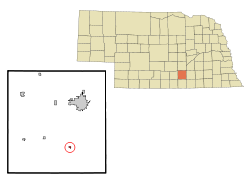
Adams County Nebraska Incorporated and Unincorporated areas Ayr Highlighted.svg
Location of Ayr, Nebraska
Coordinates: 40°26′16″N98°26′27″W / 40.43778°N 98.44083°W / 40.43778; -98.44083
Country United States
State Nebraska
County Adams
Area
[1]
  Total0.24 sq mi (0.63 km2)
  Land0.24 sq mi (0.63 km2)
  Water0.00 sq mi (0.00 km2)
Elevation
[2]
1,831 ft (558 m)
Population
 (2020)
  Total83
  Density342.98/sq mi (132.27/km2)
Time zone UTC-6 (Central (CST))
  Summer (DST) UTC-5 (CDT)
ZIP code
68925
Area code 402
FIPS code 31-02865 [3]
GNIS feature ID2398015 [2]

Ayr is a village in Adams County, Nebraska, United States. The population was 94 at the 2010 census. It is part of the Hastings, Nebraska Micropolitan Statistical Area.

Contents

History

Ayr got its start in the year 1878, following construction of the railroad through the territory. [4] [5] It was named for Doctor Ayr, a railroad official from Iowa. [6] [7] [8] Ayr was incorporated as a village in 1883. [6]

Geography

According to the United States Census Bureau, the village has a total area of 0.18 square miles (0.47 km2), all land. [9]

Demographics

Historical population
CensusPop.Note
1880 128
1890 17335.2%
1900 141−18.5%
1910 1420.7%
1920 16415.5%
1930 1777.9%
1940 152−14.1%
1950 121−20.4%
1960 111−8.3%
1970 14026.1%
1980 112−20.0%
1990 101−9.8%
2000 98−3.0%
2010 94−4.1%
2020 83−11.7%
U.S. Decennial Census [10]

2010 census

As of the census [11] of 2010, there were 94 people, 35 households, and 26 families in the village. The population density was 522.2 inhabitants per square mile (201.6/km2). There were 36 housing units at an average density of 200.0 per square mile (77.2/km2). The racial makeup of the village was 100.0% White.

Of the 35 households 34.3% had children under the age of 18 living with them, 65.7% were married couples living together, 2.9% had a female householder with no husband present, 5.7% had a male householder with no wife present, and 25.7% were non-families. 22.9% of households were one person and 8.6% were one person aged 65 or older. The average household size was 2.69 and the average family size was 3.15.

The median age in the village was 43.5 years. 28.7% of residents were under the age of 18; 2.1% were between the ages of 18 and 24; 21.2% were from 25 to 44; 34.1% were from 45 to 64; and 13.8% were 65 or older. The gender makeup of the village was 50.0% male and 50.0% female.

2000 census

At the 2000 census there were 98 people, 40 households, and 32 families in the village. The population density was 568.6 inhabitants per square mile (219.5/km2). There were 42 housing units at an average density of 243.7 per square mile (94.1/km2). The racial makeup of the village was 96.94% White, 1.02% Asian, and 2.04% from two or more races. [3]

Of the 40 households 35.0% had children under the age of 18 living with them, 70.0% were married couples living together, 2.5% had a female householder with no husband present, and 20.0% were non-families. 17.5% of households were one person and 2.5% were one person aged 65 or older. The average household size was 2.45 and the average family size was 2.72.

The age distribution was 26.5% under the age of 18, 5.1% from 18 to 24, 27.6% from 25 to 44, 29.6% from 45 to 64, and 11.2% 65 or older. The median age was 36 years. For every 100 females, there were 104.2 males. For every 100 females age 18 and over, there were 100.0 males.

The median household income was $48,125, and the median family income was $51,250. Males had a median income of $31,250 versus $16,250 for females. The per capita income for the village was $16,179. There were no families and 4.5% of the population living below the poverty line, including no under eighteens and none of those over 64.

See also

Related Research Articles

<span class="mw-page-title-main">Roseland, Nebraska</span> Village in Nebraska, United States

Roseland is a village in Adams County, Nebraska, United States. The population was 260 at the 2020 census. It is part of the Hastings, Nebraska Micropolitan Statistical Area.

<span class="mw-page-title-main">Amherst, Nebraska</span> Village in Nebraska, United States

Amherst is a village in Buffalo County, Nebraska, United States. It is part of the Kearney, Nebraska Micropolitan Statistical Area. The population was 248 at the 2010 census.

<span class="mw-page-title-main">Alvo, Nebraska</span> Village in Nebraska, United States

Alvo is a village in Cass County, Nebraska, United States. The population was 115 at the 2020 census.

<span class="mw-page-title-main">Cedar Creek, Nebraska</span> Village in Nebraska, United States

Cedar Creek is a village in Cass County, Nebraska, United States. The population was 465 at the 2020 census.

<span class="mw-page-title-main">Eagle, Nebraska</span> Village in Nebraska, United States

Eagle is a village in southwest Cass County, Nebraska, United States. As of the 2020 census, the village population was 1,065.

<span class="mw-page-title-main">Elmwood, Nebraska</span> Village in Nebraska, United States

Elmwood is a village in southeast Cass County, Nebraska, United States. The population was 654 at the 2020 census.

<span class="mw-page-title-main">Murdock, Nebraska</span> Village in Nebraska, United States

Murdock is a village in Cass County, Nebraska, United States. The population was 270 according to the 2020 census.

<span class="mw-page-title-main">Nehawka, Nebraska</span> Village in Nebraska, United States

Nehawka is a village in southeast Cass County, Nebraska, United States. The population was 173 at the 2020 census.

<span class="mw-page-title-main">Ansley, Nebraska</span> Village in Nebraska, United States

Ansley is a village in Custer County, Nebraska, United States. The population was 441 at the 2010 census.

<span class="mw-page-title-main">Berwyn, Nebraska</span> Village in Custer County, Nebraska, United States

Berwyn is a village in Custer County, Nebraska, United States. The population was 83 at the 2010 census.

<span class="mw-page-title-main">Stamford, Nebraska</span> Village in Nebraska, United States

Stamford is a village in Harlan County, Nebraska, United States. The population was 183 at the 2010 census.

<span class="mw-page-title-main">Reynolds, Nebraska</span> Village in Jefferson County, Nebraska, United States

Reynolds is a village in Jefferson County, Nebraska, United States. The population was 59 at the 2020 census.

<span class="mw-page-title-main">Springview, Nebraska</span> Village in Nebraska, United States

Springview is a village in, and the county seat of, Keya Paha County, Nebraska, United States. The population was 242 at the 2010 census.

<span class="mw-page-title-main">Taylor, Nebraska</span> Village in Nebraska, United States

Taylor is a village in, and the county seat of, Loup County, Nebraska, United States. The population was 190 at the 2010 census.

<span class="mw-page-title-main">Bertrand, Nebraska</span> Village in Nebraska, United States

Bertrand is a village in Phelps County, Nebraska, United States. The population was 750 at the 2010 census.

<span class="mw-page-title-main">Cedar Bluffs, Nebraska</span> Village in Saunders County, Nebraska, United States

Cedar Bluffs is a village in Saunders County, Nebraska, United States. The population was 615 at the 2020 census. Cedar Bluffs was a point on the Mormon, Oregon, and California Trails.

<span class="mw-page-title-main">Ceresco, Nebraska</span> Village in Saunders County, Nebraska, United States

Ceresco is a farming village in Saunders County, Nebraska, United States. The population was 919 at the 2020 census. It is located near U.S. Highway 77, just north of Lincoln, just south of Wahoo, and a short distance southwest of Omaha.

<span class="mw-page-title-main">Memphis, Nebraska</span> Village in Nebraska, United States

Memphis is a village in Saunders County, Nebraska, United States. The population was 109 at the 2020 census.

<span class="mw-page-title-main">Walthill, Nebraska</span> Village in Thurston County, Nebraska, United States

Walthill is a village in Thurston County, Nebraska, United States, within the Omaha Reservation. The population was 780 at the 2010 census.

<span class="mw-page-title-main">Winnebago, Nebraska</span> Village in Thurston County, Nebraska, United States

Winnebago is a village in Thurston County, Nebraska, United States. The population was 916 at the 2020 census.

References

  1. "ArcGIS REST Services Directory". United States Census Bureau. Retrieved September 18, 2022.
  2. 1 2 U.S. Geological Survey Geographic Names Information System: Ayr, Nebraska
  3. 1 2 "U.S. Census website". United States Census Bureau . Retrieved January 31, 2008.
  4. "Ayr". Adams County Nebraska Historical Society. Retrieved April 22, 2014.
  5. Burr, George L. (1921). History of Hamilton and Clay Counties, Nebraska, Volume 1. S.J. Clarke Publishing Company. p. 96.
  6. 1 2 Burton, William R. & Lewis, David J. (1916). Past and Present of Adams County, Nebraska, Volume 1. S.J. Clarke Publishing Company. p. 402.
  7. Fitzpatrick, Lillian L. (1960). Nebraska Place-Names. University of Nebraska Press. p. 13. ISBN   0803250606.
  8. "Profile for Ayr, Nebraska". ePodunk . Retrieved July 28, 2014.
  9. "US Gazetteer files 2010". United States Census Bureau. Archived from the original on January 25, 2012. Retrieved June 24, 2012.
  10. "Census of Population and Housing". Census.gov. Retrieved June 4, 2015.
  11. "U.S. Census website". United States Census Bureau . Retrieved June 24, 2012.

Commons-logo.svg Media related to Ayr, Nebraska at Wikimedia Commons