Clarks, Nebraska | |
---|---|
Downtown Clarks: Green Street, seen from across U.S. Highway 30 | |
![]() Location in Merrick County and the state of Nebraska | |
Coordinates: 41°12′59″N97°50′22″W / 41.21639°N 97.83944°W | |
Country | United States |
State | Nebraska |
County | Merrick |
Area | |
• Total | 0.31 sq mi (0.81 km2) |
• Land | 0.31 sq mi (0.81 km2) |
• Water | 0.00 sq mi (0.00 km2) |
Elevation | 1,621 ft (494 m) |
Population | |
• Total | 344 |
• Density | 1,095.54/sq mi (423.24/km2) |
Time zone | UTC-6 (Central (CST)) |
• Summer (DST) | UTC-5 (CDT) |
ZIP code | 68628 |
Area code | 308 |
FIPS code | 31-09165 [4] |
GNIS feature ID | 2397631 [2] |
Website | villageofclarks |
Clarks is a village in Merrick County, Nebraska, United States. The population was 344 at the 2020 census. [5] It is part of the Grand Island, Nebraska Micropolitan Statistical Area.
Clarks was platted in 1866 when the Union Pacific Railroad was extended to that point. [6] [7] It is named for Silas Henry H. Clark, superintendent of the Union Pacific Railroad. [8] [9]
Clarks is in northeastern Merrick County, mostly on the northwest side of U.S. Route 30, which leads southwest 11 miles (18 km) to Central City, the county seat, and northeast the same distance to Silver Creek. According to the U.S. Census Bureau, the village of Clarks has a total area of 0.31 square miles (0.80 km2), all land. [1] The Platte River flows by less than 2 miles (3 km) southeast of the village.
Census | Pop. | Note | %± |
---|---|---|---|
1900 | 554 | — | |
1910 | 605 | 9.2% | |
1920 | 540 | −10.7% | |
1930 | 540 | 0.0% | |
1940 | 454 | −15.9% | |
1950 | 464 | 2.2% | |
1960 | 439 | −5.4% | |
1970 | 480 | 9.3% | |
1980 | 445 | −7.3% | |
1990 | 379 | −14.8% | |
2000 | 361 | −4.7% | |
2010 | 369 | 2.2% | |
2020 | 344 | −6.8% | |
U.S. Decennial Census [10] |
At the 2010 census there were 369 people, 145 households, and 105 families in the village. The population density was 1,190.3 inhabitants per square mile (459.6/km2). There were 167 housing units at an average density of 538.7 per square mile (208.0/km2). The racial makup of the village was 94.9% White, 0.3% Native American, 0.8% Asian, 1.6% from other races, and 2.4% from two or more races. Hispanic or Latino of any race were 4.1%. [11]
Of the 145 households 37.9% had children under the age of 18 living with them, 60.7% were married couples living together, 6.2% had a female householder with no husband present, 5.5% had a male householder with no wife present, and 27.6% were non-families. 23.4% of households were one person and 12.4% were one person aged 65 or older. The average household size was 2.54 and the average family size was 3.03.
The median age in the village was 39.2 years. 28.5% of residents were under the age of 18; 5.4% were between the ages of 18 and 24; 22.2% were from 25 to 44; 28.1% were from 45 to 64; and 15.7% were 65 or older. The gender makeup of the village was 47.2% male and 52.8% female.
At the 2000 census there were 361 people, 157 households, and 102 families in the village. The population density was 1,164.3 inhabitants per square mile (449.5/km2). There were 179 housing units at an average density of 577.3 per square mile (222.9/km2). The racial makup of the village was 98.06% White, 0.83% from other races, and 1.11% from two or more races. Hispanic or Latino of any race were 2.22%. [4]
Of the 157 households 26.8% had children under the age of 18 living with them, 59.2% were married couples living together, 3.8% had a female householder with no husband present, and 34.4% were non-families. 31.8% of households were one person and 21.0% were one person aged 65 or older. The average household size was 2.30 and the average family size was 2.88.
The age distribution was 23.3% under the age of 18, 5.3% from 18 to 24, 25.5% from 25 to 44, 23.5% from 45 to 64, and 22.4% 65 or older. The median age was 42 years. For every 100 females, there were 81.4 males. For every 100 females age 18 and over, there were 87.2 males.
As of 2000 the median income for a household in the village was $29,583, and the median family income was $40,625. Males had a median income of $26,875 versus $25,313 for females. The per capita income for the village was $15,742. About 12.8% of families and 16.7% of the population were below the poverty line, including 25.9% of those under age 18 and 16.3% of those age 65 or over.
Clarks Public School was a K-12 school until it consolidated with the Polk, Hordville, and Marquette school systems in 2000.
Merrick County is a county in the U.S. state of Nebraska. As of the 2020 United States Census, the population was 7,668. Its county seat is Central City.
Winona Lake is a town in Wayne Township, Kosciusko County, in the U.S. state of Indiana, and the major suburb of Warsaw. The population was 4,908 at the 2010 census.
Calverton Park is a city in St. Louis County, Missouri, United States. The population was 1,293 at the 2010 census. The Village of Calverton Park incorporated as the City of Calverton Park in 2014.
Clearwater is a village in Antelope County, Nebraska, United States. The population was 419 at the 2010 census.
Snyder is a village in Dodge County, Nebraska, United States. The population was 300 at the 2010 census.
Milligan is a village in Fillmore County, Nebraska, United States. The population was 241 at the 2020 census.
Riverton is a village in Franklin County, Nebraska, United States. The population was 89 at the 2010 census.
Alda is a village in Hall County, Nebraska, United States. The population was 642 at the 2010 census. It is part of the Grand Island, Nebraska Micropolitan Statistical Area.
Hayes Center is a village in Hayes County, Nebraska, United States, which has served as that county's county seat since 1885. Its population, according to the 2010 U.S. census, was 214.
Firth is a village in Lancaster County, Nebraska, United States. It is part of the Lincoln, Nebraska Metropolitan Statistical Area. The population was 649 at the 2020 census.
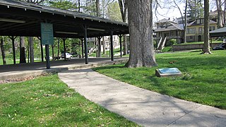
Chapman is a village in Merrick County, Nebraska, United States. The population was 260 at the 2020 census. It is part of the Grand Island metropolitan area.
Palmer is a village in Merrick County, Nebraska, United States. The population was 439 at the 2020 census. It is part of the Grand Island metropolitan area.
Silver Creek is a village in Merrick County, Nebraska, United States. The population was 320 at the 2020 census. It is part of the Grand Island metropolitan area.
Osmond is a city in Pierce County, Nebraska, United States. It is part of the Norfolk, Nebraska Micropolitan Statistical Area. The population was 791 at the 2020 census.
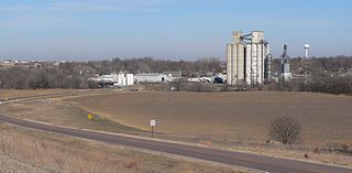
Stromsburg is a city in Polk County, Nebraska, United States. The population was 1,028 as per the 2020 census.
Sherwood is a village in Calumet County, Wisconsin, United States. The population was 2,713 at the 2010 census. The former historical unincorporated community of High Cliff is located within present-day Sherwood.
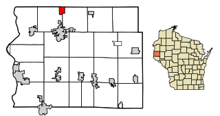
Readstown is a village in Vernon County, Wisconsin, United States. The population was 376 at the 2020 census.
Tilden is a city in Madison and Antelope counties in Nebraska, United States. The population was 992 at the 2020 census. The Madison County portion of Tilden is part of the Norfolk Micropolitan Statistical Area.
Winter is a village in Sawyer County, Wisconsin, United States. The population was 233 at the 2010 census. The village is within the Town of Winter.
Star Prairie is a village in St. Croix County in the U.S. state of Wisconsin. The population was 561 at the 2010 census. The village is located along the Apple River on the boundary between the Town of Star Prairie and the Town of Stanton.