Grand Island, Nebraska

Last updated

Grand Island, Nebraska
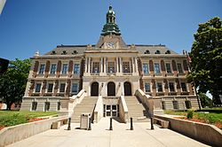
Hall Co Courthouse 6.jpg
Hall County Courthouse in Grand Island,
June 2014
Nickname: 
La Grande Ile
Hall County Nebraska Incorporated and Unincorporated areas Grand Island Highlighted.svg
Location of Grand Island in County and State
Coordinates: 40°55′18″N98°21′31″W / 40.92167°N 98.35861°W / 40.92167; -98.35861
CountryUnited States
State Nebraska
County Hall
Government
  MayorRoger Steele
Area
[1]
  Total30.28 sq mi (78.44 km2)
  Land30.09 sq mi (77.92 km2)
  Water0.20 sq mi (0.51 km2)
Elevation
[2]
1,870 ft (570 m)
Population
 (2020)
  Total53,131
  Rank4th in Nebraska
  Density1,765.97/sq mi (681.85/km2)
Demonym Grand Islander
Time zone UTC−6 (CST)
  Summer (DST) UTC−5 (CDT)
ZIP code
68801-68803
Area code 308
FIPS code 31-19595
GNIS feature ID838031 [2]
Website grand-island.com

Grand Island is a city in and the county seat of Hall County, Nebraska, United States. [3] The population was 53,131 at the 2020 census, making it the 4th most populous city in Nebraska. [4] Grand Island is the principal city of the Grand Island metropolitan area, which consists of Hall, Merrick, Howard and Hamilton counties. The Grand Island metropolitan area has an official population of 83,472 residents. [5]

Contents

Grand Island has been given the All-America City Award four times (1955, 1967, 1981, and 1982) by the National Civic League.

Grand Island is home to the Nebraska Law Enforcement Training Center, which is the sole agency responsible for training law enforcement officers throughout the state, as well as the home of the Southern Power District serving southern Nebraska. Ammunition manufacturer Hornady is also located there.

History

Grand Island, 1867 Grand Island, Nebraska (1867).jpg
Grand Island, 1867
Aerial view of Grand Island, 1925 Nebraska - Benedict through Grant - NARA - 23942149 (cropped).jpg
Aerial view of Grand Island, 1925

19th century

In 1857, 35 German settlers left Davenport, Iowa, and headed west to Nebraska to start a new settlement on an island [6] known by French traders as La Grande Isle, which was formed by the Wood River and the Platte River. The settlers reached their destination on July 4, 1857, and by September had built housing using local timber. They set up farms but initially had no market to sell their goods until a market opened at Fort Kearny. When the Pike's Peak Gold Rush began, Grand Island was the last place travelers could obtain supplies before they crossed the plains. [6]

Surveyors from the Union Pacific Railroad (UP) laid out a town called Grand Island Station and many settlers living on Grand Island moved to the new town, located slightly inland from the island. [7] In 1868 the railroad reached the area, bringing increased trade and business. Grand Island became the end of the east division of the railroad and UP built service facilities for their locomotives in the town as well as an elegant hotel for passengers providing a boost for the local economy. The cost of the railroad coming into town was the denudement of most of the hardwood trees on the island for use as ties for the railroad. [6] By 1870, 1,057 people lived in the town, and in 1872 the town was incorporated as Grand Island. [8]

In about 1890, sugar beets were introduced as a crop in Nebraska. The first sugar beet processing factory in the United States was built in the southwest part of Grand Island. [8] By 1900, it the state's third largest city.

20th century

Throughout the 20th century, Grand Island experienced steady growth due to its strategic location along the railroad. The city remained Nebraska's third largest city throughout the entire century, before being surpassed by Bellevue in 2000. [9]

21st century

Grand Island has experienced a number of revitalization efforts in the 21st century. [10] These include several expansions to the city's airport, as well as the relocation of the Nebraska State Fair to Grand Island. [11]

1980 tornadoes

On June 3, 1980, Grand Island was hit by a massive supercell storm. Through the course of the evening, the city was ravaged by seven tornadoes, the worst of which was rated F4 on the Fujita Scale. The hardest hit area of town was the South Locust business district. There were five deaths as a result of the tornadoes.

Tornado Hill is a local landmark created as a direct result of the tornadoes. Debris that could not be recycled was burned near Fonner Park and what remained was buried within Ryder Park, on the west end of town. The base of the hill was a hole 6–8 feet deep and nearly 200 feet across, and the hill is 40 feet high. It is used for sledding in this otherwise flat area. [12]

A book, Night of the Twisters , by Ivy Ruckman, and movie were based on this event. [13]

Geography

According to the United States Census Bureau, the city has a total area of 28.55 square miles (73.94 km2), of which 28.41 square miles (73.58 km2) is land and 0.14 square miles (0.36 km2) is water. [14]

Grand Island is located just a few miles north of the Platte River, one of Nebraska's most prominent rivers on which many of the state's major cities and towns sit.[ citation needed ]

Metropolitan area

The Grand Island Metropolitan Statistical Area consists of Hall, Hamilton, Howard, and Merrick counties. Hamilton was added to the metropolitan area in 2012. The Grand Island MSA is home to 76,479 people (2023 estimate), making it one of the smallest in the United States. [15]

Climate

Climate data for Grand Island, Nebraska (Central Nebraska Regional Airport), 1991–2020 normals, [a] extremes 1895–present
MonthJanFebMarAprMayJunJulAugSepOctNovDecYear
Record high °F (°C)76
(24)
80
(27)
90
(32)
98
(37)
104
(40)
108
(42)
117
(47)
112
(44)
109
(43)
97
(36)
88
(31)
80
(27)
117
(47)
Mean maximum °F (°C)59.8
(15.4)
65.1
(18.4)
76.8
(24.9)
85.8
(29.9)
92.3
(33.5)
97.7
(36.5)
99.9
(37.7)
97.5
(36.4)
94.3
(34.6)
86.3
(30.2)
74.0
(23.3)
61.3
(16.3)
101.7
(38.7)
Mean daily maximum °F (°C)36.1
(2.3)
40.4
(4.7)
52.6
(11.4)
63.3
(17.4)
73.4
(23.0)
84.4
(29.1)
88.1
(31.2)
85.8
(29.9)
79.3
(26.3)
65.6
(18.7)
51.1
(10.6)
38.9
(3.8)
63.2
(17.3)
Daily mean °F (°C)25.9
(−3.4)
29.7
(−1.3)
40.7
(4.8)
51.0
(10.6)
62.0
(16.7)
72.8
(22.7)
77.0
(25.0)
74.6
(23.7)
66.6
(19.2)
53.1
(11.7)
39.6
(4.2)
28.9
(−1.7)
51.8
(11.0)
Mean daily minimum °F (°C)15.6
(−9.1)
19.1
(−7.2)
28.8
(−1.8)
38.6
(3.7)
50.5
(10.3)
61.1
(16.2)
65.8
(18.8)
63.5
(17.5)
53.9
(12.2)
40.6
(4.8)
28.1
(−2.2)
18.9
(−7.3)
40.4
(4.7)
Mean minimum °F (°C)−6.8
(−21.6)
−2.2
(−19.0)
8.1
(−13.3)
22.2
(−5.4)
34.7
(1.5)
47.5
(8.6)
54.0
(12.2)
51.3
(10.7)
37.5
(3.1)
22.7
(−5.2)
9.9
(−12.3)
−1.8
(−18.8)
−11.9
(−24.4)
Record low °F (°C)−29
(−34)
−34
(−37)
−21
(−29)
−1
(−18)
22
(−6)
36
(2)
42
(6)
38
(3)
20
(−7)
6
(−14)
−11
(−24)
−26
(−32)
−34
(−37)
Average precipitation inches (mm)0.61
(15)
0.74
(19)
1.39
(35)
2.52
(64)
4.70
(119)
4.01
(102)
3.51
(89)
3.20
(81)
2.00
(51)
1.99
(51)
1.10
(28)
0.84
(21)
26.61
(676)
Average snowfall inches (cm)6.8
(17)
7.3
(19)
3.8
(9.7)
1.6
(4.1)
0.0
(0.0)
0.0
(0.0)
0.0
(0.0)
0.0
(0.0)
0.1
(0.25)
1.1
(2.8)
2.3
(5.8)
4.7
(12)
27.7
(70)
Average precipitation days (≥ 0.01 in)5.55.67.08.911.610.29.18.56.86.54.95.389.9
Average snowy days (≥ 0.1 in)4.64.32.41.00.10.00.00.00.00.61.63.518.1
Source: NOAA [16] [17]

Environmental issues

In 1981, a plume of contaminated groundwater was discovered beneath the Cornhusker Army Ammunition Plant, which occupies 20 square miles (52 km2) west of Grand Island. The plume extended northeast of the plant and migrated towards Grand Island. Hazardous level of RDX and TNT were discovered, [18] remnants of the explosives produced at the plant during various wars. In 1987, the Army burned about 40,000 tons of explosives-contaminated soil. In 1998, a pump-and-treat facility that continues to operate was built to cycle contaminated water through an explosives residue-removal system. The Army injected "hot spots" of contamination substances to curtail the contamination.[ citation needed ]As of 2014, TNT and RDX were still present. [18] Construction of a primary water detention cell for flood control has been delayed by the slow cleanup. [18]

Demographics

Historical population
CensusPop.Note
1870 1,057
1880 2,963180.3%
1890 7,536154.3%
1900 7,5540.2%
1910 10,32636.7%
1920 13,94735.1%
1930 18,04129.4%
1940 19,1306.0%
1950 22,68218.6%
1960 25,74213.5%
1970 32,35825.7%
1980 33,1802.5%
1990 39,38618.7%
2000 42,9409.0%
2010 48,52013.0%
2020 53,1319.5%
U.S. Decennial Census [19] [4]

2020 census

The 2020 United States census [20] counted 53,131 people, 19,601 households, and 12,983 families in Grand Island. The population density was 1,765.7 per square mile (681.9/km2). There were 20,758 housing units at an average density of 689.9 per square mile (266.4/km2). The racial makeup was 65.82% (34,970) white, 3.53% (1,876) black or African-American, 1.62% (859) Native American, 1.31% (695) Asian, 0.07% (35) Pacific Islander, 17.33% (9,205) from other races, and 10.33% (5,491) from two or more races. Hispanic or Latino of any race was 32.0% (16,585) of the population.

Of the 19,601 households, 35.4% had children under the age of 18; 46.5% were married couples living together; 25.2% had a female householder with no husband present. 27.5% of households consisted of individuals and 11.6% had someone living alone who was 65 years of age or older. The average household size was 2.6 and the average family size was 3.1.

27.2% of the population was under the age of 18, 7.9% from 18 to 24, 25.4% from 25 to 44, 22.1% from 45 to 64, and 14.0% who were 65 years of age or older. The median age was 35.0 years. For every 100 females, the population had 103.4 males. For every 100 females ages 18 and older, there were 100.8 males.

The 2016-2020 5-year American Community Survey [21] estimates show that the median household income was $56,513 (with a margin of error of +/- $3,441) and the median family income $66,755 (+/- $4,142). Males had a median income of $37,579 (+/- $2,047) versus $29,532 (+/- $1,595) for females. The median income for those above 16 years old was $33,197 (+/- $1,293). Approximately, 9.3% of families and 11.8% of the population were below the poverty line, including 16.6% of those under the age of 18 and 10.2% of those ages 65 or over.

2010 census

As of the census [22] of 2010, there were 48,520 people, 18,326 households, and 11,846 families living in the city. The population density was 1,707.8 inhabitants per square mile (659.4/km2). There were 19,426 housing units at an average density of 683.8 per square mile (264.0/km2). The racial makeup of the city was 80.0% White, 2.1% African American, 1.0% Native American, 1.2% Asian, 0.2% Pacific Islander, 13.1% from other races, and 2.4% from two or more races. Hispanic or Latino people of any race were 26.7% of the population.

There were 18,326 households, of which 35.4% had children under the age of 18 living with them, 47.5% were married couples living together, 12.0% had a female householder with no husband present, 5.2% had a male householder with no wife present, and 35.4% were non-families. 29.1% of all households were made up of individuals, and 11.2% had someone living alone who was 65 years of age or older. The average household size was 2.59 and the average family size was 3.20.

The median age in the city was 34.7 years. 27.6% of residents were under the age of 18; 8.7% were between the ages of 18 and 24; 26.7% were from 25 to 44; 23.9% were from 45 to 64; and 13% were 65 years of age or older. The gender makeup of the city was 49.8% male and 50.2% female.

2000 census

As of the census of 2000, there were 42,940 people, 16,426 households, and 11,038 families living in the city.[ citation needed ] The population density was 2,000.2 inhabitants per square mile (772.3/km2). There were 17,421 housing units at an average density of 811.5 per square mile (313.3/km2). The racial makeup of the city was 86.72% White, 0.42% African American, 0.33% Native American, 1.31% Asian, 0.17% Pacific Islander, 9.64% from other races, and 1.42% from two or more races. Hispanic or Latino people of any race were 15.94% of the population.[ citation needed ]

There were 16,426 households, out of which 34.3% had children under the age of 18 living with them, 53.0% were married couples living together, 10.4% had a female householder with no husband present, and 32.8% were non-families. 27.1% of all households were made up of individuals, and 11.1% had someone living alone who was 65 years of age or older. The average household size was 2.55 and the average family size was 3.09.[ citation needed ]

In the city, the population was spread out, with 27.0% under the age of 18, 9.5% from 18 to 24, 28.6% from 25 to 44, 20.8% from 45 to 64, and 14.1% who were 65 years of age or older. The median age was 35 years. For every 100 females, there were 98.1 males. For every 100 females aged 18 and over, there were 96.0 males.[ citation needed ]

The median income for a household in the city was $36,044, and the median income for a family was $43,197. Males had a median income of $28,925 versus $20,521 for females. The per capita income for the city was $17,071. About 9.9% of families and 12.8% of the population were below the poverty line, including 16.7% of those under age 18 and 8.1% of those aged 65 or over.[ citation needed ]

Arts and culture

Nebraska State Fair

In 2010, Grand Island became the home of the Nebraska State Fair. [23] Each year, the fair attracts thousands of people to the city, with a record attendance of over 300,000 in 2024. [24]

Exterior of the Stuhr Museum Sthurmuseum.jpg
Exterior of the Stuhr Museum

Stuhr Museum

The Stuhr Museum, also known as the Museum of the Pioneer Prarie, is a museum located in southwestern Grand Island. [25] The museum houses over 140,000 artifacts from early settlers in central Nebraska, and features a living history village called Railroad Town. Railroad Town is designed to evoke an 1890s-era prairie village and made up of many original period structures moved to the museum. [26]

Parks and recreation

There are several parks located within Grand Island. The most prominent of these include Stolley Park, and the George Clayton Hall County Park. [27]

Infrastructure

Interstate 80 near Grand Island Interstate 80 - Nebraska - 14416636976.jpg
Interstate 80 near Grand Island

Transportation

Major highways

Interstate 80 is located four miles south of the city. U.S. Route 281 is the main north-south route in the city, running through the city's west edge south to Hastings, and north to O'Neill. U.S. Route 30 runs east-west through the center of Grand Island.

Airport

Central Nebraska Regional Airport is located in Grand Island. On September 4, 2008, Allegiant Air began nonstop service from Grand Island to Las Vegas, Nevada. In June 2011, American Eagle Airlines began providing service to Dallas/Fort Worth, Texas, twice daily. [28]

Intercity buses operated by Burlington Trailways and Express Arrow serve Grand Island. [29] [30]

The city's transit system is entirely demand-responsive, with rides requiring reservation 24 hours in advance. [31] As of 2023, Grand Island is the largest city in Nebraska without fixed-route public transit. Fixed route service was studied, but not recommended, in the GO Grand Island Transit 2023 Transit Development Plan. [32]

Grand Island also sports a total of fifteen traffic circles, many of which are within close proximity to each other. This system allows for particularly efficient through-traffic while sacrificing speed and barring transportation to some locations by certain, longer vehicles. [33] Of these fifteen recorded roundabouts, fourteen are designated "official," while one is reportedly an "unofficial" insertion into the Grand Island's public transportation network. [34]

Hospitals

As of 2024, Grand Island is served by CHI Health St. Francis Hospital, with 153 beds. [35]

The city is also served by Grand Island Regional Medical Center, which opened in 2020. [36]

Media

Radio stations

Education

School districts

High schools

Colleges

Notable people

See also

Notes

  1. Mean monthly maxima and minima (i.e. the highest and lowest temperature readings during an entire month or year) calculated based on data at said location from 1991 to 2020.

Related Research Articles

<span class="mw-page-title-main">Prosser, Nebraska</span> Village in Adams County, Nebraska, United States

Prosser is a village in Adams County, Nebraska, United States. The population was 73 at the 2020 census. It is part of the Hastings, Nebraska, Micropolitan Statistical Area.

<span class="mw-page-title-main">Alliance, Nebraska</span> City in Nebraska, United States

Alliance is a city and the county seat of Box Butte County, in the western part of the state of Nebraska, in the Great Plains region of the United States. Its population was 8,151 at the 2020 census.

<span class="mw-page-title-main">Kearney, Nebraska</span> City in the United States

Kearney is the county seat of Buffalo County, Nebraska, United States. The population was 33,790 in the 2020 census, making it the 5th most populous city in Nebraska. It is home to the University of Nebraska at Kearney. The westward push of the railroad as the Civil War ended gave new birth to the community.

<span class="mw-page-title-main">Imperial, Nebraska</span> City in Nebraska, United States

Imperial is a city in Chase County, Nebraska, United States. The population was 2,071 at the 2010 census. It is the county seat of Chase County.

<span class="mw-page-title-main">Dalton, Nebraska</span> Village in Nebraska, United States

Dalton is a village in Cheyenne County, Nebraska, United States. The population was 315 at the 2010 census.

<span class="mw-page-title-main">Edgar, Nebraska</span> City in Nebraska, United States

Edgar is a city in Clay County, Nebraska, United States. The population was 498 at the 2010 census. It is part of the Hastings, Nebraska Micropolitan Statistical Area.

<span class="mw-page-title-main">Lexington, Nebraska</span> City in Nebraska, United States

Lexington is a city in Dawson County, Nebraska, United States. The population was 10,348 at the 2020 census, making it the 16th most populous city in Nebraska. It is the county seat of Dawson County. Lexington is located in southern Nebraska, on the Platte River, southeast of North Platte. It sits along the route of U.S. Route 30 and the Union Pacific Railroad. In the 1860s, Lexington was the location of a stop along the Pony Express.

<span class="mw-page-title-main">Allen, Nebraska</span> Village in Dixon County, Nebraska, United States

Allen is a village in Dixon County, Nebraska, United States. Located south of US Hwy 20 on NE Hwy 9 between Martinsburg, NE and Wakefield, NE. It is part of the Sioux City, IA–NE–SD Metropolitan Statistical Area. The population was 377 at the 2010 census.

<span class="mw-page-title-main">Scribner, Nebraska</span> City in Nebraska, United States

Scribner is a city in Dodge County, Nebraska, United States. The population was 857 at the 2010 census.

<span class="mw-page-title-main">Bennington, Nebraska</span> City in Douglas County, Nebraska, United States

Bennington is a city in Douglas County, Nebraska, United States. The population was 2,026 at the 2020 U.S. Census.

<span class="mw-page-title-main">Wood River, Nebraska</span> Village in Hall County, Nebraska, United States

Wood River is a city in southwestern Hall County, Nebraska, United States. The population was 1,172 at the 2020 census. It is part of the Grand Island, Nebraska Metropolitan Statistical Area.

<span class="mw-page-title-main">Alma, Nebraska</span> City in Nebraska, United States

Alma is a city in Harlan County, Nebraska, United States. The population was 1,133 at the 2010 census. It is the county seat of Harlan County.

<span class="mw-page-title-main">Atkinson, Nebraska</span> City in Nebraska, United States

Atkinson is a city in Holt County, Nebraska, United States. The population was 1,245 at the 2010 census.

<span class="mw-page-title-main">Reynolds, Nebraska</span> Village in Jefferson County, Nebraska, United States

Reynolds is a village in Jefferson County, Nebraska, United States. The population was 59 at the 2020 census.

<span class="mw-page-title-main">Chapman, Nebraska</span> Village in Nebraska, United States

Chapman is a village in Merrick County, Nebraska, United States. The population was 260 at the 2020 census. It is part of the Grand Island metropolitan area.

<span class="mw-page-title-main">Clarks, Nebraska</span> Village in Nebraska, United States

Clarks is a village in Merrick County, Nebraska, United States. The population was 344 at the 2020 census. It is part of the Grand Island, Nebraska Micropolitan Statistical Area.

<span class="mw-page-title-main">Humphrey, Nebraska</span> City in Platte County, Nebraska, United States

Humphrey is a city in Platte County, Nebraska, United States. The population was 760 at the 2010 census.

<span class="mw-page-title-main">Crete, Nebraska</span> City in Saline County, Nebraska, United States

Crete is a city in and the most populous municipality of Saline County, Nebraska, United States. The population was 7,099 at the 2020 census. The city is home to Doane University.

<span class="mw-page-title-main">Gretna, Nebraska</span> City in Sarpy County, Nebraska, United States

Gretna is a city in Sarpy County, Nebraska, United States. The population was 9,071 at the 2022 census.

<span class="mw-page-title-main">Belvidere, Nebraska</span> Village in Thayer County, Nebraska, United States

Belvidere is a village in Thayer County, Nebraska, United States. The population was 51 at the 2020 census.

References

  1. "ArcGIS REST Services Directory". United States Census Bureau. Retrieved September 18, 2022.
  2. 1 2 U.S. Geological Survey Geographic Names Information System: Grand Island, Nebraska
  3. "Find a County". National Association of Counties. Archived from the original on May 31, 2011. Retrieved June 7, 2011.
  4. 1 2 "United States Census Bureau QuickFacts". United States Census Bureau. Retrieved February 13, 2022.
  5. "Grand Island, you are officially a metro area". Omaha World Herald. Archived from the original on April 11, 2013. Retrieved March 14, 2013.
  6. 1 2 3 Bowman, J. R. (1882). Shearer, Frederick E. (ed.). The Pacific tourist. J.R. Bowman's illustrated transcontinental guide of travel from the Atlantic to the Pacific Ocean. New York: J.R. Bowman. p. 26. OCLC   752667534 . Retrieved May 13, 2018.
  7. "History". City of Grand Island, Nebraska. 2011. Archived from the original on June 23, 2011. Retrieved June 2, 2011.
  8. 1 2 "The Pioneer Spirit". City of Grand Island, Nebraska. 2011. Archived from the original on June 23, 2011. Retrieved June 2, 2011.
  9. "Grand Island History". visitgrandisland.com. Retrieved October 24, 2024.
  10. "Error". city2.grand-island.com. Retrieved October 24, 2024.
  11. "Nebraska State Fair | Grand Island NE". www.statefair.org. July 15, 2021. Retrieved October 24, 2024.
  12. Frisvold, Brad (2011). "The Real Night of the Twisters". gitwisters.com. Grand Island, NE: The Independent. Archived from the original on July 31, 2012. Retrieved June 2, 2011.
  13. O'Neill, Colleen (2011). "The Real Night of the Twisters". gitwisters.com. Grand Island, NE: The Independent. Archived from the original on January 11, 2013. Retrieved June 2, 2011.
  14. "US Gazetteer files 2010". United States Census Bureau. Archived from the original on January 25, 2012. Retrieved June 24, 2012.
  15. "Wayback Machine". March 26, 2010. Archived from the original on March 26, 2010. Retrieved October 24, 2024.
  16. "NOWData - NOAA Online Weather Data". National Oceanic and Atmospheric Administration. Retrieved January 13, 2022.
  17. "Station: Grand Island AP, NE". U.S. Climate Normals 2020: U.S. Monthly Climate Normals (1991–2020). National Oceanic and Atmospheric Administration. Retrieved January 13, 2022.
  18. 1 2 3 Tracy Overstreet (December 10, 2014). "Off-site RDX contamination cleanup completed". Grand Island Independent. BH Media Group Holdings, Inc. Retrieved December 13, 2014.
  19. United States Census Bureau. "Census of Population and Housing" . Retrieved June 22, 2013.
  20. "Explore Census Data". data.census.gov. Retrieved December 18, 2023.
  21. "Explore Census Data". data.census.gov. Retrieved December 18, 2023.
  22. "U.S. Census website". United States Census Bureau . Retrieved June 24, 2012.
  23. "Nebraska State Fair". Nebraska State Fair Park. Archived from the original on October 14, 2009. Retrieved October 2, 2009.
  24. "2024 Nebraska State Fair had highest attendance in 7 years". Siouxland Proud. September 5, 2024. Retrieved October 22, 2024.
  25. "Our Story". Stuhr Museum. Retrieved October 24, 2024.
  26. "Railroad Town".
  27. "GIPARKS". October 23, 2024.
  28. "Newsroom - Home - American Airlines Group, Inc". Hub.aa.com. Archived from the original on September 20, 2015. Retrieved November 26, 2017.
  29. "Our Route Schedules" . Retrieved May 30, 2023.
  30. "NEBRASKA The Cornhusker State". March 23, 2017. Retrieved May 30, 2023.
  31. "Transit - City of Grand Island, NE". www.grand-island.com. Archived from the original on January 2, 2018. Retrieved May 1, 2018.
  32. "GO Grand Island Transit Final Report February 2023" . Retrieved May 30, 2023.
  33. "Transportation Improvement Program | City of Grand Island, NE". www.grand-island.com. Retrieved August 5, 2022.
  34. "Roundabout Information | City of Grand Island, NE". www.grand-island.com. Retrieved August 5, 2022.
  35. "State of Nebraska Hospital Roster" (PDF). Nebraska Department of Health and Human Services. Retrieved June 18, 2024.
  36. White, Steve (March 16, 2023). "Hospital that opened during pandemic welcomes Grand Island to visit". NTV News. Retrieved June 18, 2024.
  37. Bain, David Haward (2004). The Old Iron Road: An Epic of Rails, Roads, and the Urge to Go West. New York City, New York: Penguin Books. pp. 60–2. ISBN   0-14-303526-6.
  38. "Former G.I. resident Rebecca Richards-Kortum named MacArthur ‘Genius'". Grand Island Independent. September 23, 2016. Retrieved June 24, 2017.
  39. "Soldier-Lawyer of Utah is Dead". The Salt Lake Tribune . Salt Lake City, UT. February 1, 1920. p. 1 via Newspapers.com.
  40. Biographical and Historical Memoirs of Adams, Clay, Hall and Hamilton Counties, Nebraska. Chicago, IL: Goodspeed Publishing Co. 1890. pp. 702–703 via HathiTrust.