References
- ↑ U.S. Geological Survey Geographic Names Information System: Lockwood, Nebraska
- ↑ Lockwood, James (1889). Descendants of Robert Lockwood: Colonial and Revolutionary history of the Lockwood family in America, from A.D. 1630. Printed privately by the family. p. 684.
- ↑ Sedgwick, Theron E. (1921). York County, Nebraska and Its People: Together with a Condensed History of the State. S.J. Clarke. p. 129.
- ↑ "Merrick County". Jim Forte Postal History. Retrieved August 19, 2014.
Municipalities and communities of Merrick County, Nebraska, United States | ||
|---|---|---|
| City | 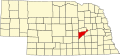 | |
| Villages | ||
| Townships | ||
| CDP | ||
| Other communities | ||
40°58′12″N98°14′40″W / 40.97000°N 98.24444°W
| | This Merrick County, Nebraska state location article is a stub. You can help Wikipedia by expanding it. |