Royal, Nebraska

Last updated

Royal, Nebraska
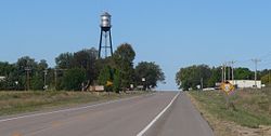
Royal, Nebraska from E 1.JPG
Royal, seen from the east along U.S. Highway 20
Antelope County Nebraska Incorporated and Unincorporated areas Royal Highlighted.svg
Location of Royal, Nebraska
Coordinates: 42°19′59″N98°07′30″W / 42.33306°N 98.12500°W / 42.33306; -98.12500
Country United States
State Nebraska
County Antelope
Established1890 [1]
Area
[2]
  Total0.14 sq mi (0.37 km2)
  Land0.14 sq mi (0.37 km2)
  Water0.00 sq mi (0.00 km2)
Elevation
[3]
1,880 ft (570 m)
Population
 (2020)
  Total58
  Density408.45/sq mi (158.23/km2)
Time zone UTC-6 (Central (CST))
  Summer (DST) UTC-5 (CDT)
ZIP code
68773
Area code 402
FIPS code 31-42495 [4]
GNIS feature ID2399137 [3]

Royal is a village in Antelope County, Nebraska, United States. The population was 63 at the 2010 census.

Contents

History

The community was established in 1890 (or 1880 [5] ), and was originally named "Savage". [1] The community was renamed after Royal Thayer, who helped establish the post office. [6]

An unusual point in the town's history is the defunct "Zoo Nebraska", which was near Royal. After some chimpanzees escaped, and were killed, the zoo gained some national attention [7] and then ultimately collapsed. [8] In 2019 a book about the zoo and the incident was released. [9] [10] [11]

Geography

According to the United States Census Bureau, the village has a total area of 0.14 square miles (0.36 km2), all land. [12]

Demographics

Historical population
CensusPop.Note
1920 202
1930 2177.4%
1940 193−11.1%
1950 157−18.7%
1960 93−40.8%
1970 86−7.5%
1980 860.0%
1990 81−5.8%
2000 75−7.4%
2010 63−16.0%
2020 58−7.9%
U.S. Decennial Census [13]

2010 census

At the 2010 census there were 63 people, 29 households, and 14 families living in the village. The population density was 450.0 inhabitants per square mile (173.7/km2). There were 38 housing units at an average density of 271.4 per square mile (104.8/km2). The racial makeup of the village was 98.4% White and 1.6% from two or more races. Hispanic or Latino of any race were 1.6%. [14]

Of the 29 households 24.1% had children under the age of 18 living with them, 37.9% were married couples living together, 3.4% had a female householder with no husband present, 6.9% had a male householder with no wife present, and 51.7% were non-families. 41.4% of households were one person and 17.2% were one person aged 65 or older. The average household size was 2.17 and the average family size was 2.79.

The median age in the village was 45.1 years. 19% of residents were under the age of 18; 7.9% were between the ages of 18 and 24; 22.2% were from 25 to 44; 36.5% were from 45 to 64; and 14.3% were 65 or older. The gender makeup of the village was 55.6% male and 44.4% female.

2000 census

At the 2000 census there were 75 people, 34 households, and 21 families living in the village. The population density was 523.6 inhabitants per square mile (202.2/km2). There were 40 housing units at an average density of 279.3 per square mile (107.8/km2). The racial makeup of the village was 100.00% White. [4] Of the 34 households 29.4% had children under the age of 18 living with them, 58.8% were married couples living together, and 38.2% were non-families. 38.2% of households were one person and 23.5% were one person aged 65 or older. The average household size was 2.21 and the average family size was 2.90.

The age distribution was 22.7% under the age of 18, 8.0% from 18 to 24, 26.7% from 25 to 44, 20.0% from 45 to 64, and 22.7% 65 or older. The median age was 42 years. For every 100 females, there were 87.5 males. For every 100 females age 18 and over, there were 123.1 males.

The median household income was $27,292, and the median family income was $50,000. Males had a median income of $34,063 versus $18,125 for females. The per capita income for the village was $13,414. There were 7.7% of families and 6.6% of the population living below the poverty line, including no under eighteens and 19.0% of those over 64.
Education

Royal was formerly in Nebraska Unified School District 1. [15] As per the website it is now in Summerland Public Schools. [16]

Parks and recreation

The Ashfall Fossil Beds State Historical Park is located six miles from Royal. The park features well preserved skeletons of prehistoric animals, and is a joint project of the Nebraska Game and Parks Commission and the University of Nebraska State Museum. [1] [17]

See also

Related Research Articles

<span class="mw-page-title-main">Antelope County, Nebraska</span> County in Nebraska, United States

Antelope County is a county located in the U.S. state of Nebraska. As of the 2020 United States Census, the population was 6,295. Its county seat is Neligh. The county was formed in 1871. It received its name after a group of early settlers killed and ate several pronghorn. Although these are not true antelope, they are colloquially known by that name.

<span class="mw-page-title-main">Ayr, Nebraska</span> Village in Adams County, Nebraska, United States.

Ayr is a village in Adams County, Nebraska, United States. The population was 94 at the 2010 census. It is part of the Hastings, Nebraska Micropolitan Statistical Area.

<span class="mw-page-title-main">Holstein, Nebraska</span> Village in Adams County, Nebraska, United States

Holstein is a village in Adams County, Nebraska, United States. The population was 188 at the 2020 census. It is part of the Hastings, Nebraska Micropolitan Statistical Area.

<span class="mw-page-title-main">Prosser, Nebraska</span> Village in Adams County, Nebraska, United States

Prosser is a village in Adams County, Nebraska, United States. The population was 73 at the 2020 census. It is part of the Hastings, Nebraska, Micropolitan Statistical Area.

<span class="mw-page-title-main">Clearwater, Nebraska</span> Village in Antelope County, Nebraska, United States

Clearwater is a village in Antelope County, Nebraska, United States. The population was 419 at the 2010 census.

<span class="mw-page-title-main">Orchard, Nebraska</span> Village in Antelope County, Nebraska, United States

Orchard is a village in Antelope County, Nebraska, United States. The population was 379 at the 2010 census.

<span class="mw-page-title-main">Snyder, Nebraska</span> Village in Nebraska, United States

Snyder is a village in Dodge County, Nebraska, United States. The population was 300 at the 2010 census.

<span class="mw-page-title-main">Uehling, Nebraska</span> Village in Nebraska, United States

Uehling is a village in Dodge County, Nebraska, United States. The population was 230 at the 2010 census.

<span class="mw-page-title-main">Waterloo, Nebraska</span> Village in Douglas County, Nebraska, United States

Waterloo is a village in Douglas County, Nebraska, United States. The population was 935 at the 2020 census.

<span class="mw-page-title-main">Pickrell, Nebraska</span> Village in Nebraska, United States

Pickrell is a village in Gage County, Nebraska, United States. As of the 2020 census, the village population was 186.

<span class="mw-page-title-main">Greeley Center, Nebraska</span> Village in Greeley County, Nebraska, United States

Greeley Center, often shortened to simply Greeley, is a village in and the county seat of Greeley County, Nebraska, United States. The population was 466 at the 2010 census.

<span class="mw-page-title-main">Emmet, Nebraska</span> Village in Holt County, Nebraska, United States

Emmet is a village in Holt County, Nebraska, United States. The population was 48 at the 2010 census.

<span class="mw-page-title-main">Ewing, Nebraska</span> Village in Holt County, Nebraska, United States

Ewing is a village in Holt County, Nebraska, United States. The population was 387 at the 2010 census.

<span class="mw-page-title-main">Sterling, Nebraska</span> Village in Nebraska, United States

Sterling is a village in Johnson County, Nebraska, United States. The population was 482 at the 2020 census.

<span class="mw-page-title-main">Norman, Nebraska</span> Village in Nebraska, United States

Norman is a village in Kearney County, Nebraska, United States. It is part of the Kearney, Nebraska Micropolitan Statistical Area. The population was 36 at the 2020 census.

<span class="mw-page-title-main">Santee, Nebraska</span> Village in Nebraska, United States

Santee is the principal village of the Santee Sioux Reservation in Knox County, Nebraska, United States. The population was 346 at the 2010 census.

<span class="mw-page-title-main">Taylor, Nebraska</span> Village in Nebraska, United States

Taylor is a village in, and the county seat of, Loup County, Nebraska, United States. The population was 190 at the 2010 census.

<span class="mw-page-title-main">Palmyra, Nebraska</span> Village in Nebraska, United States

Palmyra is a village in northwest Otoe County, Nebraska, United States. The population was 534 at the 2020 census.

<span class="mw-page-title-main">Rockville, Nebraska</span> Village in Sherman County, Nebraska, United States

Rockville is a village in Sherman County, Nebraska, United States. The population was 106 at the 2010 census.

<span class="mw-page-title-main">Herman, Nebraska</span> Village in Washington County, Nebraska, United States

Herman is a village in Washington County, Nebraska, United States. The population was 268 at the 2010 census.

References

  1. 1 2 3 "Royal Nebraska". Royal Nebraska. Retrieved October 19, 2012.
  2. "ArcGIS REST Services Directory". United States Census Bureau. Retrieved September 18, 2022.
  3. 1 2 U.S. Geological Survey Geographic Names Information System: Royal, Nebraska
  4. 1 2 "U.S. Census website". United States Census Bureau . Retrieved January 31, 2008.
  5. Burr, George L. (1921). History of Hamilton and Clay Counties, Nebraska, Volume 1. S.J. Clarke Publishing Company. p. 96.
  6. "Profile for Royal, Nebraska, NE". ePodunk. Retrieved October 19, 2012.
  7. AP via Fox News
  8. Norfolk Daily News
  9. "Hansen: The short, strange journey of Nebraska's smallest zoo, coming to bookstores near you"
  10. Publishers Weekly
  11. First Things
  12. "US Gazetteer files 2010". United States Census Bureau. Archived from the original on July 2, 2012. Retrieved June 24, 2012.
  13. "Census of Population and Housing". Census.gov. Retrieved June 4, 2015.
  14. "U.S. Census website". United States Census Bureau . Retrieved June 24, 2012.
  15. "2020 CENSUS - SCHOOL DISTRICT REFERENCE MAP: Antelope County, NE" (PDF). U.S. Census Bureau . Retrieved November 29, 2022.
  16. "Home". Nebraska Unified School District 1 . Retrieved November 29, 2022. WE ARE NOW PART OF SUMMERLAND PUBLIC SCHOOL
  17. "Ashfall Fossil Beds State Historical Park". University of Nebraska State Museum. Retrieved October 19, 2012.