Orchard, Nebraska

Last updated
Orchard, Nebraska
Orchard, Nebraska IMAC 1.JPG
IMAC plant in Orchard, June 2010. The plant produces anti-caking agents and starter media for cheese production.
Antelope County Nebraska Incorporated and Unincorporated areas Orchard Highlighted.svg
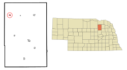
Location of Orchard, Nebraska
Coordinates: 42°20′11″N98°14′27″W / 42.33639°N 98.24083°W / 42.33639; -98.24083
Country United States
State Nebraska
County Antelope
Established1881
Area
[1]
  Total0.40 sq mi (1.02 km2)
  Land0.40 sq mi (1.02 km2)
  Water0.00 sq mi (0.00 km2)
Elevation
[2]
1,942 ft (592 m)
Population
 (2020)
  Total363
  Density918.99/sq mi (355.04/km2)
Time zone UTC-6 (Central (CST))
  Summer (DST) UTC-5 (CDT)
ZIP code
68764
Area code 402
FIPS code 31-37210 [3]
GNIS feature ID2399581 [2]

Orchard is a village in Antelope County, Nebraska, United States. The population was 379 at the 2010 census. [4]

Contents

History

Orchard was founded in 1880 when the railroad was extended to that point. [5] [6] It took its name from local apple orchards. [7] [8]

Recreation

Approximately one block north of Orchard Public School, there is a collection of recreational facilities, including two baseball fields, a municipal pool, a playground area, tennis court, and batting cage.

Education

Summerland Public Schools formed in 2020 after absorbing the Orchard school district. [9]

Orchard was formerly in Nebraska Unified School District 1. [10] Around 2007, the villages of Clearwater, Orchard, Royal and Verdigre became the Unified School District #1 and began sharing administration between them. Subsequent to this, in 2009, presumably due to a lack of funds and a lack of student participation on both ends, school rivals, the Orchard Orioles football team, and the Clearwater Cardinals football team, combined to form the O-C Cyclones. After the initial trial year, it was decided that all sports teams between the two schools would combine under the O-C Cyclones banner. The school systems have since combined to form the Clearwater-Orchard Public Schools.[ citation needed ]

Orchard is served by the Orchard Public Library. [11]

Geography

According to the United States Census Bureau, the village has a total area of 0.45 square miles (1.17 km2), all land. [12]

Climate

This climatic region is typified by large seasonal temperature differences, with warm to hot (and often humid) summers and cold (sometimes severely cold) winters. According to the Köppen Climate Classification system, Orchard has a humid continental climate, abbreviated "Dfa" on climate maps. [13]

Demographics

Historical population
CensusPop.Note
1910 532
1920 444−16.5%
1930 50513.7%
1940 493−2.4%
1950 458−7.1%
1960 421−8.1%
1970 46710.9%
1980 4823.2%
1990 439−8.9%
2000 391−10.9%
2010 379−3.1%
2020 363−4.2%
U.S. Decennial Census [14]

2010 census

As of the census [15] of 2010, there were 379 people, 176 households, and 111 families living in the village. The population density was 842.2 inhabitants per square mile (325.2/km2). There were 214 housing units at an average density of 475.6 per square mile (183.6/km2). The racial makeup of the village was 98.2% White, 1.1% from other races, and 0.8% from two or more races. Hispanic or Latino of any race were 2.4% of the population.

There were 176 households, of which 21.6% had children under the age of 18 living with them, 54.5% were married couples living together, 5.7% had a female householder with no husband present, 2.8% had a male householder with no wife present, and 36.9% were non-families. 33.5% of all households were made up of individuals, and 18.2% had someone living alone who was 65 years of age or older. The average household size was 2.15 and the average family size was 2.71.

The median age in the village was 48.3 years. 20.3% of residents were under the age of 18; 8.7% were between the ages of 18 and 24; 16.3% were from 25 to 44; 29.8% were from 45 to 64; and 24.8% were 65 years of age or older. The gender makeup of the village was 50.7% male and 49.3% female.

2000 census

As of the census [3] of 2000, there were 391 people, 183 households, and 120 families living in the village. The population density was 937.1 inhabitants per square mile (361.8/km2). There were 208 housing units at an average density of 498.5 per square mile (192.5/km2). The racial makeup of the village was 100.00% White.

There were 183 households, out of which 20.8% had children under the age of 18 living with them, 57.4% were married couples living together, 7.7% had a female householder with no husband present, and 34.4% were non-families. 32.2% of all households were made up of individuals, and 21.3% had someone living alone who was 65 years of age or older. The average household size was 2.14 and the average family size was 2.68.

In the village, the population was spread out, with 20.2% under the age of 18, 6.1% from 18 to 24, 20.7% from 25 to 44, 29.4% from 45 to 64, and 23.5% who were 65 years of age or older. The median age was 47 years. For every 100 females there were 89.8 males. For every 100 females age 18 and over, there were 85.7 males.

As of 2000 the median income for a household in the village was $21,771, and the median income for a family was $29,063. Males had a median income of $27,813 versus $16,719 for females. The per capita income for the village was $13,075. About 11.7% of families and 16.3% of the population were below the poverty line, including 20.3% of those under age 18 and 20.2% of those age 65 or over.

Media

The only media is the Antelope County News/Orchard News. The publication is now located in Neligh, Nebraska, but remains the legal newspaper for the community. It is owned by Orchard native Carrie Pitzer. While Orchard has no television or radio stations within the village itself, KGRD is licensed in Orchard, Nebraska. The station is a Christian radio station and broadcasts out of O'Neill, Nebraska.

See also

Related Research Articles

<span class="mw-page-title-main">Antelope County, Nebraska</span> County in Nebraska, United States

Antelope County is a county located in the U.S. state of Nebraska. As of the 2020 United States Census, the population was 6,295. Its county seat is Neligh. The county was formed in 1871. It received its name after a group of early settlers killed and ate several pronghorn. Although these are not true antelope, they are colloquially known by that name.

<span class="mw-page-title-main">Quartz Hill, California</span> Census-designated place in California, United States

Quartz Hill is a census-designated place (CDP) in Los Angeles County, California, United States. The population was 10,912 at the 2010 census, up from 9,890 at the 2000 census. The name is also shared with the neighboring district areas of its border cities, Palmdale, and Lancaster. Quartz Hill was once home to the Quartz Hill Airport. According to the Greater Antelope Valley Economic Alliance report of 2009, the Palmdale / Lancaster urban area of which Quartz Hill is a part, has a population of 483,998.

<span class="mw-page-title-main">Brunswick, Nebraska</span> Village in Antalope County, Nebraska, United States

Brunswick is a village in Antelope County, Nebraska, United States. The population was 138 at the 2010 census.

<span class="mw-page-title-main">Clearwater, Nebraska</span> Village in Antelope County, Nebraska, United States

Clearwater is a village in Antelope County, Nebraska, United States. The population was 419 at the 2010 census.

<span class="mw-page-title-main">Elgin, Nebraska</span> City in Antelope County, Nebraska, United States

Elgin is a city in Antelope County, Nebraska, United States. The population was 661 at the 2010 census.

<span class="mw-page-title-main">Neligh, Nebraska</span> City in and county seat of Antelope County, Nebraska, U.S.

NelighNEE-lee is a city and county seat in Antelope County, Nebraska, United States. The population was 1,599 at the 2010 census.

<span class="mw-page-title-main">Oakdale, Nebraska</span> Village in Antelope County, Nebraska, United States

Oakdale is a village in Antelope County, Nebraska, United States. The population was 322 at the 2010 census.

<span class="mw-page-title-main">Royal, Nebraska</span> Village in Antelope County, Nebraska, United States

Royal is a village in Antelope County, Nebraska, United States. The population was 63 at the 2010 census.

<span class="mw-page-title-main">Butte, Nebraska</span> Village in Nebraska, United States

Butte is a small town in, and the county seat of, Boyd County, Nebraska, United States. Its population was 326 according to the 2010 census, down from 366 in 2000.

<span class="mw-page-title-main">Ainsworth, Nebraska</span> City in and county seat of Brown County, Nebraska, United States

Ainsworth is a city and county seat of Brown County, Nebraska, United States. The population was 1,728 at the 2010 census.

<span class="mw-page-title-main">Merriman, Nebraska</span> Village in Nebraska, United States

Merriman is a village in Cherry County, Nebraska. The population was 128 at the time of the 2010 census.

<span class="mw-page-title-main">Anselmo, Nebraska</span> Village in Nebraska, United States

Anselmo is a village in Custer County, Nebraska, United States. The population was 145 at the 2010 census.

<span class="mw-page-title-main">Dodge, Nebraska</span> Village in Nebraska, United States

Dodge is a village in Dodge County, Nebraska, United States. The population was 612 at the 2010 census.

<span class="mw-page-title-main">Greeley Center, Nebraska</span> Village in Greeley County, Nebraska, United States

Greeley Center, often shortened to simply Greeley, is a village in and the county seat of Greeley County, Nebraska, United States. The population was 466 at the 2010 census.

<span class="mw-page-title-main">Crab Orchard, Nebraska</span> Village in Nebraska, United States

Crab Orchard is a village in Johnson County, Nebraska, United States. As of the 2020 census, the village population was 47.

<span class="mw-page-title-main">Springview, Nebraska</span> Village in Nebraska, United States

Springview is a village in, and the county seat of, Keya Paha County, Nebraska, United States. The population was 242 at the 2010 census.

<span class="mw-page-title-main">Niobrara, Nebraska</span> Village in Knox County, Nebraska, United States

Niobrara is a village in Knox County, Nebraska, United States. The population was 363 at the 2020 census.

<span class="mw-page-title-main">Meadow Grove, Nebraska</span> Village in Nebraska, United States

Meadow Grove is a village in Madison County, Nebraska, United States. It is part of the Norfolk, Nebraska Micropolitan Statistical Area. The population was 301 at the 2010 census.

<span class="mw-page-title-main">Table Rock, Nebraska</span> Village in Nebraska, United States

Table Rock is a village in Pawnee County, Nebraska, United States. The population was 236 at the 2020 census.

<span class="mw-page-title-main">Tilden, Nebraska</span> City in Antelope and Madison counties in Nebraska, United States

Tilden is a city in Antelope and Madison counties in Nebraska, United States. The population was 953 at the 2010 census. The Madison County portion of Tilden is part of the Norfolk, Nebraska Micropolitan Statistical Area.

References

  1. "ArcGIS REST Services Directory". United States Census Bureau. Retrieved September 18, 2022.
  2. 1 2 U.S. Geological Survey Geographic Names Information System: Orchard, Nebraska
  3. 1 2 "U.S. Census website". United States Census Bureau . Retrieved 2008-01-31.
  4. "Race, Hispanic or Latino, Age, and Housing Occupancy: 2010". United States Census Bureau . U.S. Census Bureau. Retrieved 9 May 2011.
  5. Burr, George L. (1921). History of Hamilton and Clay Counties, Nebraska, Volume 1. S.J. Clarke Publishing Company. p. 96.
  6. "Orchard, Antelope County". Center for Advanced Land Management Information Technologies. University of Nebraska. Retrieved 29 July 2014.
  7. Fitzpatrick, Lillian L. (1960). Nebraska Place-Names. University of Nebraska Press. p. 16. ISBN   0803250606.
  8. "Profile for Orchard, Nebraska". ePodunk . Retrieved 29 July 2014.
  9. "SCHOOL FINANCE AND ORGANIZATION SERVICES CUMULATIVE DISTRICT DISSOLUTIONS - 1990/91 thru 2021/22" (PDF). Nebraska Department of Education. pp. 2, 3, and 44. Retrieved 2022-11-27.
  10. "2020 CENSUS - SCHOOL DISTRICT REFERENCE MAP: Antelope County, NE" (PDF). U.S. Census Bureau . Retrieved 2022-11-29.
  11. "Homepage". Orchard Public Library. Retrieved 29 July 2014.
  12. "US Gazetteer files 2010". United States Census Bureau. Archived from the original on January 12, 2012. Retrieved 2012-06-24.
  13. Climate Summary for Orchard, Nebraska
  14. "Census of Population and Housing". Census.gov. Retrieved June 4, 2015.
  15. "U.S. Census website". United States Census Bureau . Retrieved 2012-06-24.

Commons-logo.svg Media related to Orchard, Nebraska at Wikimedia Commons