Route information | ||||
---|---|---|---|---|
Maintained by NDOT | ||||
Length | 489.46 mi [1] (787.71 km) | |||
Major junctions | ||||
West end | WYO 92 west of Lyman | |||
US 26 in Melbeta US 385 west of Broadwater US 83 east of Stapleton US 183 in Ansley US 281 in St. Paul US 30 southwest of Clarks US 77 west of Wahoo US 275 south of Waterloo I-80 in Omaha US 75 in Omaha | ||||
East end | US 275 / Iowa 92 at Missouri River in Omaha | |||
Location | ||||
Country | United States | |||
State | Nebraska | |||
Counties | Scotts Bluff, Morrill, Garden, Keith, Arthur, McPherson, Logan, Custer, Sherman, Howard, Merrick, Polk, Butler, Saunders, Douglas | |||
Highway system | ||||
|
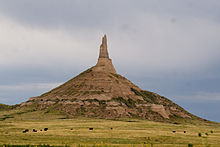
Nebraska Highway 92 is a highway that enters the state from Nebraska's western border at the Wyoming state line west of Lyman, Nebraska, to the state's eastern border on the South Omaha Veterans Memorial Bridge over the Missouri River in Omaha, where it enters Iowa. Nebraska Highway 92 passes, follows, or runs through a number of the state's principal attractions, including Scotts Bluff National Monument, the Oregon Trail, Chimney Rock National Historic Site, Ash Hollow State Historical Park, Lake McConaughy, the Nebraska Sand Hills, and the City of Omaha. Nebraska Highway 92 is the longest state route in the state at a total of 489.1 miles (787.1 km), and is part of a continuous 886-mile (1,426 km) four-state "Highway 92" which begins in Torrington, Wyoming, goes through Nebraska and Iowa and ends in La Moille, Illinois. It is the only Nebraska Highway to run from the west border to the east border of Nebraska; along the way it crosses the Platte River or its tributary North Platte River a total of five times.
N-92 begins at the Wyoming border west of Lyman and after a brief turn south, heads east passing around the north side of Scotts Bluff National Monument, crosses the North Platte River for the first of three times, and enters the town of Scottsbluff. Starting in Scottsbluff, N-92, US 26, and the North Platte River form a three-way braid, crisscrossing one another several times for 91 miles (146 km) until Lewellen. At Scottsbluff, it overlaps US 26 and N-71, crossing the North Platte River again to its south side, to Gering, where it then turns to the east-southeast, following the route of the Oregon Trail, paralleling the North Platte River and US 26 on the other side of the river. Near Chimney Rock National Historic Site, it overlaps US 26 again until Bridgeport. After a brief concurrency with US 385, it goes southeast until it crosses the North Platte for the third time just before Broadwater. It then again overlaps US 26 a third time from there until Lewellen, where it separates to go through the resort communities along the north shore of Lake McConaughy until it meets N-61. [1] [2]
It overlaps Highway 61 and goes north into the Sand Hills and separates in Arthur. It then goes east, meeting N-97 in Tryon, and encountering N-2 at Merna. It then goes southeast with Highway 2 through Broken Bow and separates at Ansley. It then runs east through Loup City and meets with US 281 in St. Paul. [1] [2]
It runs concurrently with US 281 through St. Paul, crosses the Loup River, and then separates from US 281 and goes straight east, intersects US 30, crosses the Platte River for the first of two times near Clarks and meets US 81 west of Osceola. It is then concurrent with US 81 through Osceola and Shelby, before separating east of Shelby. It then passes through Rising City and then goes straight east until it meets US 77 southwest of Wahoo, Nebraska. It passes through Wahoo concurrent with US 77 and goes east with US 77 until they separate near Mead. After passing the south edge of Yutan, it recrosses the Platte River. [1] [2]
It then encounters US 275, with which it is concurrent for the rest of its distance in Nebraska. Shortly after meeting US 275, it crosses the Elkhorn River and becomes a 4 lane divided expressway shortly before meeting US 6 and N-31. Within Omaha, it meets Interstate 80 and US 75. The street designations for N-92 in Omaha, going west to east, are West Center Road, Industrial Road, L Street and Missouri Avenue. [1] [2] It remains a four-lane suburban arterial street until it enters Iowa on the South Omaha Veterans Memorial Bridge over the Missouri River.
Originally, Route 92 followed the route of the old Oregon Trail through Mitchell Pass in Scotts Bluff National Monument, and then through Downtown Gering. It was later rerouted on a more level route around the north side of Scotts Bluff, through the town of Scottsbluff. Between 1936 and 1973, Nebraska Highway 92 was concurrent with U.S. Highway 30A from Clarks to Omaha.
County | Location | mi [1] | km | Destinations | Notes |
---|---|---|---|---|---|
Scotts Bluff | Lyman | 0.00 | 0.00 | WYO 92 west – Torrington | Continuation into Wyoming |
Scottsbluff | 23.16 | 37.27 | US 26 west | Western end of US 26 overlap | |
23.78 | 38.27 | N-71 north | Western end of N-71 overlap | ||
27.19 | 43.76 | US 26 east | Eastern end of US 26 overlap | ||
| 27.76 | 44.68 | South Beltline Highway – Scottsbluff | Partial interchange; westbound exit only | |
Gering | 29.92 | 48.15 | N-71 south | Interchange; eastern end of N-71 overlap | |
Melbeta | 36.18 | 58.23 | L-79E north | ||
Morrill | Bayard | 47.23 | 76.01 | US 26 west | Western end of US 26 overlap |
Bridgeport | 59.76 | 96.17 | US 26 east / US 385 north (M Street) | Eastern end of US 26 overlap; western end of US 385 overlap | |
60.23 | 96.93 | N-88 south (M Street) | Northern terminus of N-88 | ||
| 67.89 | 109.26 | US 385 south | Eastern end of US 385 overlap | |
Broadwater | 75.91 | 122.17 | US 26 west (Guthrie Street) | Western end of US 26 overlap | |
Garden | Oshkosh | 105.47 | 169.74 | N-27 south | Northern terminus of N-27 (middle segment) |
Lewellen | 118.31 | 190.40 | US 26 east | Eastern end of US 26 overlap | |
Keith | Lemoyne | 142.06 | 228.62 | N-61 south | Western end of N-61 overlap |
Arthur | Arthur | 167.51 | 269.58 | N-61 north | Eastern end of N-61 overlap |
McPherson | Tryon | 206.70 | 332.65 | N-97 north | Western end of N-97 overlap |
| 211.17 | 339.85 | N-97 south | Eastern end of N-97 overlap | |
Logan | Stapleton | 232.17 | 373.64 | US 83 north | Western end of US 83 overlap |
| 236.17 | 380.08 | US 83 south | Eastern end of US 83 overlap | |
Custer | Arnold | 252.28 | 406.01 | N-40 east (Carroll Street) | Western terminus of N-40 |
Merna | 276.45 | 444.90 | N-2 west (E Street) | Western end of N-2 overlap | |
Broken Bow | 285.72 | 459.82 | N-21 south (8th Avenue) | Northern terminus of N-21 | |
286.89 | 461.70 | N-70 east | Western terminus of N-70 | ||
Ansley | 302.37 | 486.62 | US 183 south / N-2 east | Eastern end of N-2 overlap; western end of US 183 overlap | |
302.77 | 487.26 | US 183 north | Eastern end of US 183 overlap | ||
Sherman | Loup City | 323.07 | 519.93 | N-58 north | Western end of N-58 overlap |
323.79 | 521.09 | R-82B east (O Street) / N-10 south – Sherman Reservoir State Recreation Area | Northern terminus of N-10; western terminus of R-82B | ||
326.04 | 524.71 | N-58 south | Eastern end of N-58 overlap | ||
Howard | | 343.35 | 552.57 | S-47A south | |
| 347.10 | 558.60 | N-11 (Naper Road) | ||
St. Paul | 352.56 | 567.39 | US 281 north | Western end of US 281 overlap | |
354.94 | 571.22 | US 281 south | Eastern end of US 281 overlap | ||
Merrick | | 364.55 | 586.69 | S-61A | |
| 377.50 | 607.53 | N-14 south | Western end of N-14 overlap | |
| 378.51 | 609.15 | N-14 north (17th Road) | Eastern end of N-14 overlap | |
| 384.28 | 618.44 | US 30 – Columbus, Grand Island | One-quadrant interchange; access via unsigned L-61D | |
Polk | | 396.02 | 637.33 | N-39 north | Southern terminus of N-39 |
| 399.02 | 642.16 | US 81 south (Center Road) – York | Western end of US 81 overlap | |
Shelby | 408.42 | 657.29 | N-69 south (Walnut Street) | Northern terminus of N-69 | |
Polk–Butler county line | | 411.44 | 662.15 | US 81 north – Columbus | Eastern end of US 81 overlap |
Butler | | 414.42 | 666.94 | S-12E south | |
| 424.40 | 683.01 | N-15 north (Mn Road) | Western end of N-15 overlap | |
| 425.92 | 685.45 | N-15 south (Road O) | Eastern end of N-15 overlap | |
| 430.91 | 693.48 | S-12F south | ||
Saunders | | 439.92 | 707.98 | N-79 south | Western end of N-79 overlap |
| 440.94 | 709.62 | N-79 north | Eastern end of N-79 overlap | |
| 444.45 | 715.27 | S-78D south | ||
| 445.95 | 717.69 | S-78E north | ||
| 450.17 | 724.48 | US 77 south – Lincoln | Western end of US 77 overlap | |
Wahoo | 453.58 | 729.97 | N-109 north | Southern terminus of N-109 | |
| 458.79 | 738.35 | US 77 north – Fremont | Eastern end of US 77 overlap | |
| 459.80 | 739.98 | S-78F south | ||
Platte River | 465.99 | 749.94 | Bridge | ||
Douglas | | 469.80 | 756.07 | US 275 west (240th Street) – Omaha (via Dodge Street), Fremont | Western end of US 275 overlap; former US 30A east |
Omaha | 472.84 | 760.96 | US 6 / N-31 (204th Street) – Gretna, Elkhorn | Interchange | |
479.36 | 771.46 | 132nd Street / Millard Avenue (N-50 south) to I-80 | Northern terminus of N-50 | ||
480.83 | 773.82 | I-680 north / I-80 | Cloverleaf interchange with I-80 C/D lanes; I-80 exit 445; I-680 south exit 1 | ||
483.35 | 777.88 | N-85 south (84th Street) | Northern terminus of N-85 | ||
484.35 | 779.49 | 72nd Street | Interchange | ||
488.17 | 785.63 | US 75 (Kennedy Freeway) to I-80 | Interchange | ||
Missouri River | 489.46 | 787.71 | South Omaha Veterans Memorial Bridge; Nebraska–Iowa line | ||
US 275 south / Iowa 92 east (Veterans Memorial Highway) | Continuation into Iowa | ||||
1.000 mi = 1.609 km; 1.000 km = 0.621 mi
|
Interstate 80 (I-80) is an east–west transcontinental freeway that crosses the United States from downtown San Francisco, California, to Teaneck, New Jersey, in the New York metropolitan area. The highway was designated in 1956 as one of the original routes of the Interstate Highway System; its final segment was opened in 1986. The second-longest Interstate Highway in the United States after I-90, it runs through many major cities, including Oakland, Sacramento, Reno, Salt Lake City, Omaha, Des Moines, and Toledo and passes within 10 miles (16 km) of Chicago, Cleveland, and New York City.
Interstate 29 (I-29) is an Interstate Highway in the Midwestern United States. I-29 runs from Kansas City, Missouri, at a junction with I-35 and I-70, to the Canada–US border near Pembina, North Dakota, where it connects with Manitoba Provincial Trunk Highway 75 (PTH 75), which continues on to Winnipeg. The road follows the course of three major rivers, all of which form the borders of US states. The southern portion of I-29 closely parallels the Missouri River from Kansas City northward to Sioux City, Iowa, where it crosses and then parallels the Big Sioux River. For the northern third of the highway, it closely follows the Red River of the North. The major cities that I-29 connects to includes Council Bluffs, Iowa; Sioux Falls, South Dakota; Fargo, North Dakota; and Grand Forks, North Dakota.
U.S. Route 75 is a north–south U.S. Highway that runs 1,239 miles (1,994 km) in the central United States. The highway's northern terminus is located at the Canadian border near Noyes, Minnesota, at a now-closed border crossing. From this point, the highway once continued farther north as Manitoba Highway 75. Its southern terminus is located at Interstate 30 (I-30) and I-45 in Dallas, Texas, where US 75 is known as North Central Expressway.
U.S. Route 83 (US 83) is a major north–south United States Numbered Highway that extends 1,885 miles (3,034 km) in the central United States. Only four other north–south routes are longer: US 1, US 41, US 59, and US 87, while US 83 follows a straighter north-south path than all of these. Nearly half of its mileage is in the state of Texas. The highway's northern terminus is north of Westhope, North Dakota, at the Canadian border, where it continues as Manitoba Highway 83 (PTH 83). The southern terminus is at the Veterans International Bridge in Brownsville, Texas. Together, US 83 and PTH 83 form a continuously numbered north-south highway with a combined distance of 3,450 kilometres (2,140 mi).
U.S. Route 183 (US 183) is a north–south United States highway. The highway's northern terminus is in Presho, South Dakota, at an intersection with Interstate 90. Its southern terminus is in Refugio, Texas, at the southern intersection of U.S. Highway 77 and Alternate US 77.
U.S. Route 6 (US 6) or U.S. Highway 6 (US 6), also called the Grand Army of the Republic Highway, honoring the American Civil War veterans association, is a main route of the United States Numbered Highway System. While it currently runs east-northeast from Bishop, California, to Provincetown, Massachusetts, the route has been modified several times. The highway's longest-lasting routing, from 1936 to 1964, had its western terminus at Long Beach, California. During this time, US 6 was the longest highway in the country.
U.S. Route 275 (US 275) is a north–south United States highway that is a branch of US 75. It originally terminated at US 75 in Council Bluffs, Iowa. The highway's northern terminus is in O'Neill, Nebraska, at an intersection with U.S. Highway 20 and U.S. Highway 281. Its southern terminus is near Rock Port, Missouri, at an intersection with U.S. Highway 136.
Nebraska Highway 50 (N-50) is a north–south highway in the state of Nebraska. The southern terminus is at the Nebraska-Kansas border near Du Bois. The northern terminus is in the Millard neighborhood of Omaha at an intersection with U.S. Highway 275 (US 275) and N-92. It is a two lane highway except for the section from Springfield north to the southern edge of the Millard neighborhood in Omaha, which is a divided highway.
Iowa Highway 92 (Iowa 92) is a state highway that runs from east to west across the state of Iowa. Iowa 92 is 279 miles (449 km) long. It begins at the Missouri River in Council Bluffs, where it is a continuation of Nebraska Highway 92. It stretches across the state and serves to roughly demarcate the southern one-third of Iowa. It ends at the Mississippi River in Muscatine where it continues into Illinois as Illinois Route 92. In 1939, Iowa 92 replaced the original Iowa 2 in its entirety.
Nebraska Highway 2 (N-2) is a state highway in Nebraska consisting of two discontinuous segments. The western segment begins at the South Dakota border northwest of Crawford and ends southeast of Grand Island at an intersection with Interstate 80 (I-80). The eastern segment begins in Lincoln and ends at the Iowa border at Nebraska City. Previously, the two segments were connected via a route shared with U.S. Highway 34 (US 34) between Grand Island and Lincoln.
Nebraska Highway 8 (N-8) is a highway in southern and southeastern Nebraska. Its western terminus is at Nebraska Highway 14 in Superior and its eastern terminus is at U.S. Highway 73 (US 73) in Falls City. It runs through the southern tier of counties in Nebraska and is always within 10 miles (16 km) of the Kansas border.
Nebraska Highway 10 is a highway in Nebraska. Its southern terminus is at the Kansas border south of Franklin. Its northern terminus is at an intersection with Nebraska Highway 58, Nebraska Highway 92, and Recreation Road 82B in Loup City.
U.S. Highway 6 (US-6) in the U.S. state of Nebraska is a United States Numbered Highway which goes from the Colorado border west of Imperial in the west to the Iowa border in the east at Omaha. Significant portions of the highway are concurrent with other highways, most significantly, US-34 between Culbertson and Hastings. Also, from Milford east to the Iowa border, the highway is closely paralleled by Interstate 80 (I-80). Large portions of the route parallel the Chicago, Burlington and Quincy Railroad.
Nebraska Highway 14 (N-14) is a highway in the U.S. state of Nebraska. It has a southern terminus at the Kansas border, where it continues south as K-14, southwest of Superior and a northern terminus east of Niobrara at the South Dakota border.
Nebraska Highway 64 is a highway in Nebraska. There are two segments to the highway. The western segment lies in Butler County between U.S. Highway 81 and Nebraska Highway 15. The eastern segment goes through Saunders and Douglas counties between U.S. Highway 77 and U.S. Highway 75.
U.S. Highway 26 (US‑26) is an east–west highway in western Nebraska. It enters the state from Wyoming just west of Henry. The eastern terminus of US‑26 is in Ogallala at an interchange with Interstate 80 (I-80). The highway largely parallels the North Platte River for the majority of its route in Nebraska and as such, runs at a northwest-southeast angle. The highway also parallels the original paths of the Oregon Trail, the California Trail and the Mormon Pioneer Trail.
U.S. Highway 30 (US 30) is part of the United States Numbered Highway System that runs for 3,073 miles (4,946 km) from Astoria, Oregon to Atlantic City, New Jersey. Within the state of Nebraska it is a state highway that travels 451.74 miles (727.01 km) west to east across the state from the Wyoming state line west of Bushnell to the Missouri River in Blair on the Iowa state line. Despite not intersecting I-80 even once, much of its length until Grand Island is closely parallel with the interstate, not being more than a mile or two away. For most of its route, US 30 travels within the Platte River valley, adjacent to or near the river between Brule and Fremont, a distance of just over 300 miles (480 km). This corridor was also highly traveled during Westward Expansion along the California and Oregon Trails, it was also used by the Pony Express and the Transcontinental Railroad. The landscape is dominated by vast agricultural fields within the fertile Platte River valley across the center of the state, while the western portion passes through higher plains and the eastern portion through the rolling hills adjacent to the Missouri River valley.
Nebraska Highway 61 (N-61) is a 234.82-mile (377.91 km) state highway in western Nebraska, United States. The southern terminus of N-61 is at the Kansas border south of Benkelman, where the highway continues south as K-161. The northern terminus is at the South Dakota border north of Merriman, where the highway continues north as South Dakota Highway 73.
U.S. Route 75 is a part of the United States Numbered Highway System that runs for 1,239 miles (1,994 km) from Dallas, Texas to Kittson County, Minnesota where it ends just short of the Canada–United States border. Within the State of Nebraska it is a state highway that enters Nebraska on the Kansas state line about 9 miles (14 km) south of Dawson and travels north across the extreme eastern portion of the state, to the Nebraska–Iowa border in South Sioux City where it crosses the Missouri River along a concurrency with Interstate 129. The northern 210 miles (340 km) of the route generally travels parallel to the Missouri River. The 87.32-mile (140.53 km) section between the I-680 interchange in Omaha and the Interstate 129 interchange is designated the Lewis & Clark Scenic Byway, one of nine scenic byways in the state.