Highway names | |
---|---|
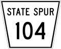
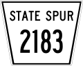
State spur: | State Spur XXX (Spur XXX) |
System links | |
Per state law in Nebraska, all communities with a population above 1000 residents are to be connected to the state highway system. Prior to the 1970s, short spur routes that were offshoots of main highways were given route numbers based on the main highway. The spurs were numbered sequentially from west to east or north to south and prefixed to the main route's number. For instance, the spur from U.S. Highway 6 (US 6) into Champion was numbered Spur 106 and the spur from US 183 into Huntley was Spur 2183.
In 1970, the Nebraska Department of Roads gave all of the state spurs new route numbers. The change was initiated to create a system of secondary highways that was expandable and followed a pattern. The new route numbers were given a letter prefix of S, L, or R, for Spur, Link, or Recreation Road, respectively, a number which identified the county in alphabetical order, and a letter suffix identified each particular route. For instance, Spur 208 into Liberty was renumbered S-34A and Spur 715 into Western was renumbered S-76C. [1]
Number | Length (mi) | Length (km) | Southern or western terminus | Northern or eastern terminus | Formed | Removed | Notes | |
---|---|---|---|---|---|---|---|---|
Spur 104 | — | — | — | — | 1957 | 1970 | Became S-91A | |
Spur 106 | — | — | — | — | 1957 | 1970 | Became S-15A | |
Spur 109 | — | — | — | — | 1957 | 1970 | Became S-87A | |
Spur 115 | — | — | — | — | 1957 | 1970 | Became S-12A | |
Spur 126 | — | — | — | — | 1957 | 1970 | Became S-79A | |
Spur 129 | — | — | — | — | 1950 | 1970 | Became S-4A | |
Spur 134 | — | — | — | — | 1957 | 1970 | Became S-1D | |
Spur 150 | — | — | — | — | 1957 | 1970 | Became S-13A | |
Spur 151 | — | — | — | — | 1957 | 1970 | Became L-20A | |
Spur 165 | — | — | — | — | 1957 | 1970 | Became S-67C | |
Spur 174 | — | — | — | — | 1957 | 1970 | Became S-18E | |
Spur 177 | — | — | — | — | 1957 | 1970 | Became S-87B | |
Spur 181 | — | — | — | — | 1957 | 1970 | Became S-71B | |
Spur 187 | — | — | — | — | 1957 | 1970 | Became S-6A | |
Spur 192 | — | — | — | — | 1957 | 1970 | Became S-61A | |
Spur 202 | — | — | — | — | 1957 | 1970 | Became S-86B | |
Spur 203 | — | — | — | — | 1957 | 1960 | Renumbered 2136 | |
Spur 203S | — | — | — | — | 1957 | 1960 | Renumbered 208 | |
Spur 204 | — | — | — | — | 1957 | 1970 | Became S-65A | |
Spur 206 | — | — | — | — | 1957 | 1970 | Became S-1A | |
Spur 208 | — | — | — | — | 1960 | 1970 | Became S-34A | |
Spur 210 | — | — | — | — | 1957 | 1970 | Became S-31A | |
Spur 214 | — | — | — | — | 1957 | 1970 | Became S-16B | |
Spur 215 | — | — | — | — | 1957 | 1970 | Became S-12A | |
Spur 226 | — | — | — | — | 1957 | 1970 | Became L-79D | |
Spur 230 | — | — | — | — | 1957 | 1970 | Became S-17A | |
Spur 234 | — | — | — | — | 1957 | 1970 | Became S-13B | |
Spur 241 | — | — | — | — | 1957 | 1970 | Became S-76D | |
Spur 259 | — | — | — | — | 1957 | 1970 | Became S-54E | |
Spur 274 | — | — | — | — | 1957 | 1970 | Became S-18F | |
Spur 277 | — | — | — | — | 1957 | 1970 | Became S-55F | |
Spur 292 | — | — | — | — | 1957 | 1970 | Became S-12E | |
Spur 302 | — | — | — | — | 1957 | 1970 | Became S-21A | |
Spur 304 | — | — | — | — | 1957 | 1970 | Became N-105 | |
Spur 306 | — | — | — | — | 1957 | 1970 | Became S-1B | |
Spur 310 | — | — | — | — | 1957 | 1970 | Became S-31B | |
Spur 314 | — | — | — | — | 1957 | 1970 | Became S-18C | |
Spur 315 | — | — | — | — | 1957 | 1970 | Became S-12C | |
Spur 320 | — | — | — | — | 1957 | 1970 | Became S-45A | |
Spur 330 | — | — | — | — | 1957 | 1970 | Former N-106, became S-56A | |
Spur 334 | — | — | — | — | 1957 | 1970 | Became S-55C | |
Spur 341 | — | — | — | — | 1957 | 1970 | Became S-34B | |
Spur 350 | — | — | — | — | 1957 | 1970 | Became S-66C | |
Spur 377 | — | — | — | — | 1957 | 1970 | Became S-55F | |
Spur 392 | — | — | — | — | 1957 | 1970 | Became S-12F | |
Spur 402 | — | — | — | — | 1957 | 1970 | Became N-2 and S-41A | |
Spur 406 | — | — | — | — | 1957 | 1970 | Became S-1C | |
Spur 410 | — | — | — | — | 1957 | 1970 | Former routing of N-10; became L-50A | |
Spur 415 | — | — | — | — | 1957 | 1970 | Became S-80A | |
Spur 420 | — | — | — | — | 1957 | 1970 | Became L-45B | |
Spur 430 | — | — | — | — | 1957 | 1970 | One portion became S-40A and remainder became an unmarked road | |
Spur 434 | — | — | — | — | 1964 | 1970 | Became L-55L | |
Spur 441 | — | — | — | — | 1957 | 1970 | ||
Spur 450 | — | — | — | — | 1957 | 1970 | ||
Spur 477 | — | — | — | — | 1957 | 1970 | Became S-55G | |
Spur 483 | — | — | — | — | 1957 | 1970 | Former routing of US 183 (later US 83); one portion became S-16B and remainder became an unmarked road | |
Spur 492 | — | — | — | — | 1957 | 1970 | Became S-78D | |
Spur 502 | — | — | — | — | 1957 | 1970 | Became S-41B | |
Spur 506 | — | — | — | — | 1957 | 1970 | Became S-18A | |
Spur 515 | — | — | — | — | 1957 | 1970 | Became S-80C | |
Spur 520 | — | — | — | — | 1957 | 1970 | Became S-2B | |
Spur 534 | — | — | — | — | 1957 | 1970 | Became S-13B (now N-63) | |
Spur 550 | — | — | — | — | 1957 | 1970 | Became S-67B | |
Spur 577 | — | — | — | — | 1957 | 1970 | Became S-55H | |
Spur 583 | — | — | — | — | 1957 | 1970 | Became S-57A | |
Spur 592 | — | — | — | — | 1957 | 1970 | Became S-78E | |
Spur 602 | — | — | — | — | 1957 | 1970 | Became S-93A | |
Spur 606 | — | — | — | — | 1957 | 1970 | Became S-76A | |
Spur 615 | — | — | — | — | 1957 | 1970 | ||
Spur 620 | — | — | — | — | 1957 | 1970 | Became S-26A | |
Spur 677 | — | — | — | — | 1957 | 1970 | ||
Spur 702 | — | — | — | — | 1957 | 1970 | Became S-80D | |
Spur 706 | — | — | — | — | 1957 | 1970 | Became S-80A | |
Spur 715 | — | — | — | — | 1957 | 1970 | ||
Spur 802 | — | — | — | — | 1957 | 1970 | Became S-66A | |
Spur 806 | — | — | — | — | 1957 | 1970 | Became S-55A | |
Spur 1116 | — | — | — | — | 1957 | 1970 | Became S-26B | |
Spur 1127 | — | — | — | — | 1957 | 1964 | Became an unmarked road | |
Spur 1183 | — | — | — | — | 1957 | 1970 | Former N-106, became S-21C | |
Spur 1275 | — | — | — | — | 1957 | 1970 | Became S-59A | |
Spur 1281 | — | — | — | — | 1957 | 1970 | Became S-91B | |
Spur 2136 | — | — | — | — | 1960 | 1970 | Became S-31C | |
Spur 2183 | — | — | — | — | 1957 | 1970 | Became S-42A | |
|
The United States Numbered Highway System is an integrated network of roads and highways numbered within a nationwide grid in the contiguous United States. As the designation and numbering of these highways were coordinated among the states, they are sometimes called Federal Highways, but the roadways were built and have always been maintained by state or local governments since their initial designation in 1926.
In the U.S. state of New Jersey, the New Jersey Department of Transportation (NJDOT) maintains a system of state highways. Every significant section of roadway maintained by the state is assigned a number, officially State Highway Route X. Interstate Highways and U.S. Highways are included in the system. State Routes are signed with the circular highway shield.
The Great Britain road numbering scheme is a numbering scheme used to classify and identify all roads in Great Britain. Each road is given a single letter and a subsequent number. Though this scheme was introduced merely to simplify funding allocations, it soon became used on maps and as a method of navigation. There are two sub-schemes in use: one for motorways, and another for non-motorway roads.
A spur route is a short road forming a branch from a longer, more important road such as a freeway, Interstate Highway, or motorway. A bypass or beltway is not considered a spur route as it typically reconnects with another or the same major road.
A routenumber, designation or abbreviation is an identifying numeric designation assigned by a highway authority to a particular stretch of roadway to distinguish it from other routes and, in many cases, also to indicate its classification, general geographical location and/or orientation. The numbers chosen may be used solely for internal administrative purposes; however, in most cases they are also displayed on roadside signage and indicated on maps.
A concurrency in a road network is an instance of one physical roadway bearing two or more different route numbers. When two roadways share the same right-of-way, it is sometimes called a common section or commons. Other terminology for a concurrency includes overlap, coincidence, duplex, triplex, multiplex, dual routing or triple routing.
In 1927, New Jersey's state highways were renumbered. The old system, which had been defined in sequence by the legislature since 1916, was growing badly, as several routes shared the same number, and many unnumbered state highways had been defined. A partial renumbering was proposed in 1926, but instead a total renumbering was done in 1927.
Texas state highways are a network of highways owned and maintained by the U.S. state of Texas. The Texas Department of Transportation (TxDOT) is the state agency responsible for the day-to-day operations and maintenance of the system. Texas has the largest state highway system, followed closely by North Carolina's state highway system. In addition to the nationally numbered Interstate Highways and U.S. Highways, the highway system consists of a main network of state highways, loops, spurs, and beltways that provide local access to the other highways. The system also includes a large network of farm to market roads that connect rural areas of the state with urban areas and the rest of the state highway system. The state also owns and maintains some park and recreational roads located near and within state and national parks, as well as recreational areas. All state highways, regardless of classification, are paved roads. The Old San Antonio Road, also known as the El Camino Real, is the oldest highway in the United States, first being blazed in 1691. The length of the highways varies from US 83's 893.4 miles (1,437.8 km) inside the state borders to Spur 200 at just 0.05 miles long.
The Massachusetts State Highway System in the U.S. Commonwealth of Massachusetts is a system of state-numbered routes assigned and marked by the highway division of the Massachusetts Department of Transportation (MassDOT). U.S. Highways and Interstate Highways are included in the system; the only overlaps are with the end-to-end U.S. Route 3 and Route 3 and the far-apart Interstate 295, shared with Rhode Island, and Route 295, shared with New York State. A state highway in Massachusetts is a road maintained by the state, which may or may not have a number. Not all numbered routes are maintained or owned by the state.
A highway shield or route marker is a sign denoting the route number of a highway, usually in the form of a symbolic shape with the route number enclosed. As the focus of the sign, the route number is usually the sign's largest element, with other items on the sign rendered in smaller sizes or contrasting colors. Highway shields are used by travellers, commuters, and all levels of government for identifying, navigating, and organising routes within a given jurisdiction. Simplified highway shields often appear on maps.
The North Carolina Highway System consists of a vast network of Interstate, United States, and state highways, managed by the North Carolina Department of Transportation. North Carolina has the second largest state maintained highway network in the United States because all roads in North Carolina are maintained by either municipalities or the state. Since counties do not maintain roads, there is no such thing as a "county road" within the state.
Exit numbers in the United States are assigned to freeway junctions, and are usually numbered as exits from freeways. Exit numbers generally are found above the destinations and route number(s) at the exit, as well as a sign in the gore. Exit numbers typically reset at political borders such as state lines. Some major streets also use exit numbers. Freeway exits in the United States are usually numbered in two formats: distance-based and sequential.
In 1955, Louisiana passed a law that undertook a comprehensive revision to the state highway classification and numbering system. The new system designated roads by importance to travel patterns and rectified the previous numbering system under new unified designations.
In the U.S. state of Pennsylvania, state highways are generally maintained by the Pennsylvania Department of Transportation (PennDOT). Each is assigned a four-digit State Route (SR) number in the present Location Referencing System. Traffic Routes are signed as Interstate Highways, U.S. Routes and Pennsylvania Routes, and are prefixed with one to three zeroes to give a four-digit number. PA Routes are also called Pennsylvania Traffic Routes, and formerly State Highway Routes.
The State Highways of Washington in the U.S. state of Washington comprise a network of over 7,000 miles (11,270 km) of state highways, including all Interstate and U.S. Highways that pass through the state, maintained by the Washington State Department of Transportation (WSDOT). The system spans 8.5% of the state's public road mileage, but carries over half of the traffic. All other public roads in the state are either inside incorporated places or are maintained by the county. The state highway symbol is a white silhouette of George Washington's head.