Lemoyne, Nebraska | |
|---|---|
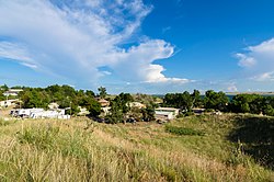 Lemoyne from the shore of Lake McConaughy | |
 Lemoyne  Lemoyne | |
| Coordinates: 41°16′36″N101°48′48″W / 41.27667°N 101.81333°W | |
| Country | United States |
| State | Nebraska |
| County | Keith |
| Founded | 1911 |
| Area | |
• Total | 0.51 sq mi (1.32 km2) |
| • Land | 0.51 sq mi (1.32 km2) |
| • Water | 0 sq mi (0.00 km2) |
| Elevation | 3,347 ft (1,020 m) |
| Population (2020) | |
• Total | 44 |
| • Density | 86.3/sq mi (33.33/km2) |
| Time zone | UTC-6 (Central (CST)) |
| • Summer (DST) | UTC-5 (CDT) |
| ZIP code | 69146 |
| FIPS code | 31-26595 |
| GNIS feature ID | 2583887 [2] |
Lemoyne is an unincorporated community and census-designated place in northwestern Keith County, Nebraska, United States. As of the 2010 census it had a population of 82. [3]
Contents
It lies along Nebraska Highway 92 on the northern shore of Lake C.W. McConaughy, 20 miles (32 km) by road north of the city of Ogallala, the county seat of Keith County. [4]
Although Lemoyne is unincorporated, it has a post office, with the ZIP code of 69146. [5]
| Census | Pop. | Note | %± |
|---|---|---|---|
| 2020 | 44 | — | |
| U.S. Decennial Census [6] | |||
