It is the home of Eastern Wyoming College, and is the surrounding region's center of commercial activity. Within this primarily agricultural community, there are several fertilizer plants, a former sugar beet factory which closed in 2019, and numerous tourist facilities and retail businesses that serve the local and nearby rural populations.[6]
History
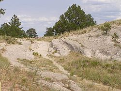
Ruts made by early pioneer's wagons on the historic Oregon Trail in the late 19th Century in Eastern Wyoming (2007 photo)Vintage photo of early 20th Century resident of the West using horses to pull his "horseless carriage" while "fording" a river
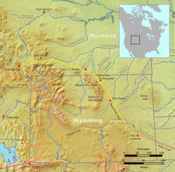
Situated on the historic Mormon Trail and near the Oregon and California trails[7] along the banks of the North Platte River, Torrington was founded in 1900 by W. G. Curtis (1857–1913), and named by him for his home town of Torrington, Connecticut. Originally a watering and coaling station for the CB&Q Railroad, which began passenger service in 1900, the town was a gathering place for nearby farmers and ranchers. In 1905, the first bridge was constructed over the North Platte River.[8]
A post office called Torrington was established in 1889 on Curtis' farm three miles west of the future town, with Curtis serving as postmaster and later as mayor. In 1908, the town incorporated in Laramie County. It had a bank, three general stores, a pharmacy with a soda fountain, a land office, and two hotels (for one of which the building, although modified, still exists at 1841 Main Street.)[8] It soon became a central place of trade for Goshen County, and for surrounding areas in eastern Wyoming and western Nebraska.[8]
The town's site survey began in April 1900, by Ashland B. Smith of the Lincoln Land Company of Nebraska. The survey and plating was recorded in Cheyenne on June 22, 1900, and individual plots of the land sold to residents for one dollar each by Charles Henry Morrill, President of the Lincoln Land Company. The Torrington Telegram[9] (which was still published in 2015) was established in 1911.[8] The 1900 United States Census lists only 71 inhabitants in the Torrington Precinct and does not list it as a town. All residents were stock growers, ranch laborers, cowboys or at school, except for one listed as a hardware clerk.
Also in 1911, Goshen County was organized.[8] The County was created from a portion of the northern end of Laramie County. The towns of Torrington and nearby Lingle—some 10 miles (16km) away—competed for designation as the county seat. Torrington prevailed after Torrington residents raised sufficient funds for a courthouse. The cornerstone for the courthouse was set in 1913, in a ceremony where a band was conducted by Hi Yoder, from whose family the nearby town of Yoder, Wyoming, takes its name.[8]
Around that time, early motor cars started showing up in town, the Goshen County Fair Association was established, and in 1915 Torrington had a population of 443.[citation needed] In 1919, the Trail Hotel building, which still exists at 2001 Main Street, was constructed. In 1925, the Union Pacific Railroad based in Omaha constructed a spur line from Cheyenne to South Torrington, to serve the proposed Holly Sugar Corporation plant, which began operations in 1926.[8]
The Torrington Livestock Commission, established in 1934,[11] still held twice-weekly livestock auctions in 2015. It is the largest livestock auction operation and barn in Wyoming, and ranks as the third to fifth largest livestock auction in the United States. Drawing cattle from a nine-state region (Nebraska, Colorado, Arizona, Nevada, Utah, Idaho, South Dakota, Montana and the bulk of Wyoming) the Torrington livestock auction barn attracts buyers from all over the nation. And, as of 2011[update], Goshen County ranked number one in Wyoming for its cattle inventory.[12][13]
As of the census[2] of 2010, there were 6,501 people, 2,527 households, and 1,506 families living in the city. The population density was 1,407.1 inhabitants per square mile (543.3/km2). There were 2,717 housing units at an average density of 588.1 per square mile (227.1/km2). The racial makeup of the city was 93.2% White, 1.0% African American, 0.9% Native American, 0.5% Asian, 0.2% Pacific Islander, 3.0% from other races, and 1.3% from two or more races. Hispanic or Latino of any race were 11.3% of the population.
There were 2,527 households, of which 26.0% had children under the age of 18 living with them, 44.8% were married couples living together, 10.2% had a female householder with no husband present, 4.6% had a male householder with no wife present, and 40.4% were non-families. 34.5% of all households were made up of individuals, and 16.1% had someone living alone who was 65 years of age or older. The average household size was 2.21 and the average family size was 2.83.
The median age in the city was 41.4 years. 19.8% of residents were under the age of 18; 11.1% were between the ages of 18 and 24; 23.2% were from 25 to 44; 26.8% were from 45 to 64; and 19.3% were 65 years of age or older. The gender makeup of the city was 52.5% male and 47.5% female.
2000 census
At the census[3] of 2000, there were 5,776 people, 2,436 households, and 1,522 families living in the city. The population density was 1,617.4 people per square mile (624.7/km2). There were 2,644 housing units at an average density of 740.4 per square mile (286.0/km2). The racial makeup of the city was 93.49% White, 0.31% African American, 0.90% Native American, 0.29% Asian, 0.10% Pacific Islander, 3.65% from other races, and 1.25% from two or more races. Hispanic or Latino of any race were 9.47% of the population.
There were 2,436 households, out of which 26.7% had children under the age of 18 living with them, 49.9% were married couples living together, 9.9% had a female householder with no husband present, and 37.5% were non-families. 32.3% of all households were made up of individuals, and 17.3% had someone living alone who was 65 years of age or older. The average household size was 2.26 and the average family size was 2.86.
The age distribution was: 23.3% under the age of 18, 9.6% from 18 to 24, 23.1% from 25 to 44, 22.9% from 45 to 64, and 21.0% who were 65 years of age or older. The median age was 41 years. For every 100 females, there were 93.0 males. For every 100 females age 18 and over, there were 87.1 males.
The median income for a household in the city was $30,136, and the median income for a family was $40,750. Males had a median income of $31,058 versus $20,101 for females. The per capita income for the city was $16,026. About 9.3% of families and 13.3% of the population were below the poverty line, including 16.0% of those under age 18 and 11.3% of those age 65 or over.
The Wyoming Medium Correctional Institution (WMCI) is located in Torrington.[21][22][23] WMCI, a facility of the Wyoming Department of Corrections, serves as an intake center for male inmates not sentenced to death. It was opened on January 6, 2010, and the first 75 inmates to be housed there arrived on January 13, 2010. By 2015, it housed over 300 inmates.[24]
Public education in Torrington is provided by Goshen County School District#1. Zoned campuses include Lincoln Elementary School (grades K–2), Trail Elementary School (grades 3–5), Torrington Middle School (grades 6–8), and Torrington High School (grades 9–12).
Other towns and communities included in the consolidated Goshen County School District include Lingle, LaGrange, Huntley, and Yoder, among others.
This page is based on this Wikipedia article Text is available under the CC BY-SA 4.0 license; additional terms may apply. Images, videos and audio are available under their respective licenses.