As part of the Hayden Expedition of 1871 and 1872, William Henry Jackson took the first photographs of the Teton Range and Yellowstone. His photographs along with the sketches by Tom Moran, were important evidence to convince Congress to protect Yellowstone National Park. Yellowstone National Park became the first National Park in 1872. Grand Teton National Park was created in 1929 and greatly expanded in 1950 after John D. Rockefeller Jr. purchased and then donated over 30,000 acres (12,000ha).[citation needed]
The town of Jackson was named in 1894 and incorporated in 1914. Some of the early buildings remain and can be found throughout the area of the Town Square.[9]
The town of Jackson elected an all-woman city government (including town council and mayor, who in turn appointed women to town marshal, town clerk and treasurer) in 1920.[10]
The first ski rope tow was built at Teton Pass in 1937 and Snow King Resort was established in 1930. Teton County has three excellent ski areas including Jackson Hole Mountain Resort in Teton Village, Grand Targhee Ski, and Summer Resort located on the western slope of the Tetons as well as Snow King Resort.
The town of Jackson is the county seat of Teton County and the only incorporated municipality in the region. Less than 3% of land in Teton County is privately owned. Of the 2,697,000 acres (1,091,000ha) in Teton County, 97% are federally or state owned/managed.
In 2009, the town of Jackson was designated as a Preserve America Community. This designation recognizes that, as a community, the town protects and celebrates its heritage, uses historic assets for economic development, and encourages people to experience and appreciate local historic resources.
Geography
Jackson is located at an elevation of 6,237 feet (1,901m) above sea level. According to the United States Census Bureau, the town has a total area of 3.009 square miles (7.79km2), of which 2.978 square miles (7.71km2) is land and 0.031 square miles (0.08km2) (1.03%) is water.[2]
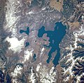
Jackson is surrounded by the Teton and Gros Ventre mountain ranges. The Teton Range is commonly associated with Jackson Hole and is a popular sightseeing attraction for many visitors. The Gros Ventre Range, by contrast, is geologically older than the Tetons and has a much broader width which encompasses huge expanses of wilderness; it is not as easily accessible.
Soils at Jackson Hole are mostly dark, excessively drained, moderately alkaline gravelly loam of the Greyback series.[11]
Flat Creek, a tributary of the Snake River, runs through the town.
Climate
Jackson experiences a humid continental climate (KöppenDfb), with warm summers and very cold winters. Due to its location in a very narrow river valley, Jackson and the rest of the Snake headwaters[12] experience a unique microclimate that gets considerably more precipitation–much of it snow–than the majority of Wyoming and has higher humidity during much of the year.[13] Its elevation is also responsible for extreme differences between day and night temperatures, which makes the climate very close to being classified as subarctic (Köppen Dfc). Extreme temperatures range from −52°F (−47°C) on December 20, 1924, to 101°F (38°C) on July 17, 1934, and July 20, 1934, and on average 236.0 mornings fall below freezing and 34.7 of these below 0°F (−18°C); the 1991 to 2020 average window for subzero Fahrenheit temperatures is from November 22 to March 3, while the window for freezing temperature is from August 22 to July 5, but freezing temperature have been recorded on every single day of the year except for July 25.[14]
Snowfall averages 78.2 inches or 1.99 meters. The highest monthly total has been 56.0 inches (1.42m) in January 1969, and the most in one season being 153.3 inches (3.89m) between July 1966 and June 1967.[14]
According to realtor website Zillow, the average price of a home as of September 30, 2025, in Jackson is $1,914,123.[19]
As of the 2023 American Community Survey, there are 4,239 estimated households in Jackson with an average of 2.5 persons per household. The town has a median household income of $112,609. Approximately 5.6% of the town's population lives at or below the poverty line. Jackson has an estimated 86.6% employment rate, with 55.0% of the population holding a bachelor's degree or higher and 95.6% holding a high school diploma.[20] There were 5,146 housing units at an average density of 1,728.01 per square mile (667.2/km2).
The top five reported languages (people were allowed to report up to two languages, thus the figures will generally add to more than 100%) were English (_%), Spanish (_%), Indo-European (_%), Asian and Pacific Islander (_%), and Other (_%).
The median age in the town was 35.0 years.
Jackson, Wyoming – racial and ethnic composition Note: the US Census treats Hispanic/Latino as an ethnic category. This table excludes Latinos from the racial categories and assigns them to a separate category. Hispanics/Latinos may be of any race.
As of the 2020 census, there were 10,760 people, 4,373 households, _ families residing in the town.[25] The population density was 3,633.91 inhabitants per square mile (1,403.1/km2). There were 4,930 housing units at an average density of 1,664.98 per square mile (642.9/km2). The racial makeup of the town was 73.23% White, 0.31% African American, 1.51% Native American, 1.62% Asian, 0.03% Pacific Islander, 10.20% from some other races and 13.10% from two or more races. Hispanic or Latino people of any race were 23.91% of the population.[26]
2010 census
As of the 2010 census, there were 9,577 people, 3,964 households, 1,858 families residing in the town. The population density was 3,291.1 inhabitants per square mile (1,270.7/km2). There were 4,736 housing units at an average density of 1,627.5 per square mile (628.4/km2). The racial makeup of the town was 79.83% White, 0.37% African American, 0.81% Native American, 1.44% Asian, 0.13% Pacific Islander, 15.15% from some other races and 2.28% from two or more races. Hispanic or Latino people of any race were 27.22% of the population.
There were 3,964 households, of which 24.7% had children under the age of 18 living with them, 35.2% were married couples living together, 6.6% had a female householder with no husband present, 5.0% had a male householder with no wife present, and 53.1% were non-families. 31.9% of all households were made up of individuals, and 5.3% had someone living alone who was 65 years of age or older. The average household size was 2.39 and the average family size was 3.04.
The median age in the town was 31.9 years. 18% of residents were under the age of 18; 11.6% were between the ages of 18 and 24; 43.8% were from 25 to 44; 20.5% were from 45 to 64; and 6.2% were 65 years of age or older. The gender makeup of the town was 54.1% male and 45.9% female.
2000 census
As of the 2000 census, there were 8,647 people, 3,631 households, 1,670 families residing in the town. The population density was 3,037.2 inhabitants per square mile (1,172.7/km2). There were 3,861 housing units at an average density of 1,356.2 per square mile (523.6/km2). The racial makeup of the town was 89.37% White, 0.21% African American, 0.77% Native American, 0.62% Asian, 0.03% Pacific Islander, 7.62% from some other races and 1.36% from two or more races. Hispanic or Latino people of any race were 11.84% of the population.
There were 3,631 households out of which 23.5% had children under the age of 18 living with them, 34.4% were married couples living together, 7.1% had a female householder with no husband present, and 54.0% were non-families. 29.9% of all households were made up of individuals, and 4.4% had someone living alone who was 65 years of age or older. The average household size was 2.35, and the average family size was 2.97.
In the town the population was spread out with 18.4% under the age of 18, 13.9% from 18 to 24, 43.7% from 25 to 44, 18.2% from 45 to 64, and 5.8% who were 65 years of age or older. The median age was 31 years. For every 100 females there were 117.5 males. For every 100 females age 18 and over, there were 118.4 males.
The median income for a household in the town was $47,757, and the median income for a family was $53,915. Males had a median income of $31,152 versus $24,307 for females. The per capita income for the town was $25,004. About 2.6% of families and 6.8% of the population were below the poverty line, including 7.3% of those under age 18 and 8.8% of those age 65 or over.
Teton Theater
Economy
As of the 2010 Census, the main industries which provide employment are: arts, entertainment, recreation, accommodation and food services (32.2%), construction (8.7%), retail trade (12.4%), educational services, health care and social assistance (11.9%), and professional, scientific, and management, and administrative and waste management services (11.8%).
A strong local economy, primarily due to tourism, has allowed Jackson to develop a large shopping and eating district characterized by a large number of art galleries, custom jewelers, and designer clothing retailers centered on the town square.[27]
Arts and culture
Center for the Arts: The center was founded in 1991 to help support an artist culture within the town. Construction of the facility was completed in 2007.[28]
Elkfest: The annual Jackson Hole Elk Antler Auction occurs each spring. At this event, members of the Boy Scouts of America help sell all the antlers collected on the nearby National Elk Refuge. Profits go to help the local Boy Scouts and the refuge.[29]
Grand Targhee Resort: About an hour away, 42 miles (68km), on the west side of the Teton Range in Alta, opened in 1969, it is accessed through Idaho over Teton Pass.
Grand Teton National Park: A national park that includes the Teton Mountain Range, roughly 310,000 acres (130,000ha). The park brings in more than two million recreational tourists each year.[31] The Grand Teton National Park is roughly 5 miles (8km) away from Jackson.[32]
Jackson Hole Mountain Resort: The resort opened in 1966, 12 miles (19km) north of Jackson. It has abundant steep terrain and has one of the highest vertical drops in North America, at 4,139 feet (1,262 m).
National Elk Refuge: The refuge was created to shelter one of the largest elk herds in the country and borders the town of Jackson. Throughout the winter visitors can go on horse-drawn sleigh rides to view the herd.
National Museum of Wildlife Art: Overlooking the National Elk Refuge is the National Museum of Wildlife Art which shows and preserves many wildlife artworks. Along with pieces inside of the museum, there is a 3⁄4-mile (1.2km) trail with many sculptures along it.
Snow King Mountain Resort: The first ski resort in Jackson and is significantly cheaper than Jackson Hole Mountain Resort. Even though Snow King is cheaper it is still quite a challenging hill. This resort is located on the Southeast edge of town. 400+ acres of skiable terrain with 3 chairlifts and a high speed summit gondola
Yellowstone National Park: Mostly in Wyoming, Yellowstone also extends into Idaho and Montana. This park was the first national park in the country, and brings in roughly four million visitors each year.[33] This park is less than 60 miles away from Jackson.[34]
[35] Schools serving the town include Jackson Elementary School (grades K–5), Colter Elementary School (grades K–5), Munger Mountain Elementary (grades K–5), Jackson Hole Middle School (grades 6–8), Jackson Hole High School (formerly Jackson-Wilson High School), Teton Science Schools (grades pre K-12), Summit Innovations High School (grades 9–12),[36] the Jackson Hole Classical Academy (grades K–12), and the Jackson Hole Community School.
The town is served by Jackson Hole Airport, the busiest airport in the state of Wyoming. Public transportation is provided by START (Southern Teton Area Rapid Transit), which connects Jackson to Teton Village and adjacent communities in Star Valley, Wyoming and Teton Valley, Idaho. There are also airport buses to Salt Lake City, and places in between.
Jackson Hole Economic Policy Symposium
Since 1978, the Kansas City Federal Reserve Bank has held an annual economic summit at Jackson (Hole) that is globally known as the Jackson Hole Economic Summit or officially as the "Jackson Hole Economic Policy Symposium". Attendees include prominent central bankers, finance ministers, and academics from around the world.[39][40][41]
It is also a major location in the action-adventure video game The Last of Us (2013) and its sequel (2020), in which it is home to a large community of survivors in a post-apocalyptic world; however, scenes set in Jackson in the game's television adaptation (2023) were instead shot in the Canadian town of Canmore, Alberta, which doubled for Jackson.[43][44]
Jackson has gained notability since a livestream of its town square went viral on YouTube in 2016, leading to much fascination with the town's elk antler arches and unusually high prevalence of red pickup trucks.[45] It first went viral when a sheriff stopped at a red light in the early hours of the morning, got out of his patrol car, and dabbed towards the camera before leaving.[46]
↑Bath, Jack (1991). Roadside Hollywood: The Movie Lover's State-By-State Guide to Film Locations, Celebrity Hangouts, Celluloid Tourist Attractions, and More. Contemporary Books. Pages 75–76. ISBN9780809243266.
This page is based on this Wikipedia article Text is available under the CC BY-SA 4.0 license; additional terms may apply. Images, videos and audio are available under their respective licenses.