Grand Teton National Park is an American national park in northwestern Wyoming. At approximately 310,000 acres (1,300 km2), the park includes the major peaks of the 40-mile-long (64 km) Teton Range as well as most of the northern sections of the valley known as Jackson Hole. Grand Teton National Park is only 10 miles (16 km) south of Yellowstone National Park, to which it is connected by the National Park Service–managed John D. Rockefeller Jr. Memorial Parkway. Along with surrounding national forests, these three protected areas constitute the almost 18-million-acre (73,000-square-kilometer) Greater Yellowstone Ecosystem, one of the world's largest intact mid-latitude temperate ecosystems.
Alta is a census-designated place (CDP) in Teton County, Wyoming, United States. The population was 394 at the 2010 census. It is part of the Jackson, WY–ID Micropolitan Statistical Area, and it is located between Driggs, Idaho and the Grand Targhee ski resort.
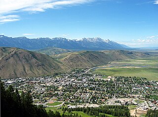
Jackson is a town in Teton County, Wyoming, United States. The population was 10,760 at the 2020 census, up from 9,577 in 2010. It is the largest town in Teton County and its county seat. Jackson is the principal town of the Jackson, WY-ID Micropolitan Statistical Area, which includes Teton County in Wyoming and Teton County in Idaho. The town, often mistakenly called Jackson Hole, derives its name from the valley in which it is located. Jackson is a popular tourist destination due to its proximity to the ski resorts Jackson Hole Mountain, Snow King Mountain, and Grand Targhee, as well as Grand Teton National Park and Yellowstone National Park.

Wilson is a census-designated place (CDP) in Teton County, Wyoming, United States. The population was 1,567 at the 2020 census, up from 1,482 in 2010. It is part of the Jackson, WY–ID Micropolitan Statistical Area.
Jackson Hole is a valley between the Gros Ventre and Teton mountain ranges in the U.S. state of Wyoming, near the border with Idaho, in Teton County, one of the richest counties in the United States. The term "hole" was used by early trappers, or mountain men, as a term for a large mountain valley. These low-lying valleys, surrounded by mountains and containing rivers and streams, are good habitat for beavers and other fur-bearing animals. Jackson Hole is 55 miles (89 km) long by 6-to-13 miles (10-to-21 km) wide and is a graben valley with an average elevation of 6,800 ft, its lowest point being near the southern park boundary at 6,350 ft.

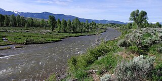
The Teton River is a 64-mile-long (103 km) tributary of the Henrys Fork of the Snake River in southeastern Idaho in the United States. It drains through the Teton Valley along the west side of the Teton Range along the Idaho-Wyoming border at the eastern end of the Snake River Plain. Its location along the western flank of the Tetons provides the river with more rainfall than many other rivers of the region.

The geology of the Grand Teton area consists of some of the oldest rocks and one of the youngest mountain ranges in North America. The Teton Range, partly located in Grand Teton National Park, started to grow some 9 million years ago. An older feature, Jackson Hole, is a basin that sits aside the range.

The Gros Ventre landslide is in the Gros Ventre Wilderness of Bridger-Teton National Forest, Wyoming, United States. The Gros Ventre landslide is seven miles (11 km) east of Jackson Hole valley and Grand Teton National Park.
The Gros Ventre River is a 74.6-mile-long (120.1 km) tributary of the Snake River in the state of Wyoming, USA. During its short course, the river flows to the east, north, west, then southwest. It rises in the Gros Ventre Wilderness in western Wyoming, and joins the Snake River in the Jackson Hole valley. In 1925, the massive Gros Ventre landslide dammed the river and formed Lower Slide Lake. The natural dam collapsed in 1927, flooding the downstream town of Kelly, Wyoming. The river is noted for the excellent trout fishing along its length, where native Snake River Fine-spotted Cutthroat Trout average 12 to 16 inches, with some to 20 inches (510 mm).

Jackson Lake Dam is a concrete and earth-fill dam in the western United States, at the outlet of Jackson Lake in northwestern Wyoming. The lake and dam are situated within Grand Teton National Park in Teton County. The Snake River emerges from the dam and flows about eight hundred miles (1,300 km) through Wyoming, Idaho, Oregon, and Washington to its mouth on the Columbia River in eastern Washington.
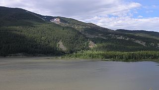
Lower Slide Lake is located in Bridger-Teton National Forest, in the U.S. state of Wyoming. The natural lake was created on June 23, 1925, when the Gros Ventre landslide dammed the Gros Ventre River. The lake was once much larger, however part of the rock dam failed less than two years later, on May 18, 1927, causing deadly flooding downstream. The lake waters have natural and stocked fish including lake and Snake River fine-spotted cutthroat trout, and mountain whitefish.

Pierre's Hole is a shallow valley in the western United States in eastern Idaho, just west of the Teton Range in Wyoming. At an elevation over 6,000 feet (1,830 m) above sea level, it collects the headwaters of the Teton River, and was a strategic center of the fur trade of the northern Rocky Mountains. The nearby Jackson's Hole area in Wyoming is on the opposite side of the Tetons.
Moran is an unincorporated village in south central Teton County, Wyoming, United States: as the community has had two different names, the Board on Geographic Names officially ruled in favor of "Moran" in 1970. It lies in Grand Teton National Park, 29 miles northeast of the city of Jackson, the county seat of Teton County, just northwest by side road of the intersection of U.S. Routes 26, 89, 191 and 287. Its elevation is 6,749 feet (2,057 m) and includes one of the principal entrance-fee collection stations for the Park. Moran also has the post office serving ZIP code of 83013, and a public elementary school; and no other services or businesses.
Mormon Row is a historic district in Teton County, Wyoming, United States that is listed on the National Register of Historic Places.

The Andy Chambers Ranch is a historic district in Teton County, Wyoming, United States, that is listed on the National Register of Historic Places.
Teton National Forest, in western Wyoming, was a United States national forest that would form a constituent part of the present-day Bridger-Teton National Forest. It was first established by the General Land Office on February 22, 1897 as the Teton Forest Reserve with 892,440 acres (3,611.6 km2). A commission was established in 1896 to plan for a system of national forest reserves, recommending an expansion of the territory protected by the Yellowstone Timberland Reserve. President Grover Cleveland's 1897 proclamation established a protected area encompassing the northern end of Jackson Hole, extending from the south boundary of the Yellowstone Forest Reserve south to the area of the Gros Ventre River, and from the Idaho border in the west to the area of the Continental Divide in the east. Much of this area would eventually be incorporated into Grand Teton National Park. In 1902 the southern porion of the Yellowstone reserve was added, while the Teton Reserve was greatly expanded to the south and east while excluding the southern portion of Jackson Hole around the town of Jackson.

The Minidoka Project is a series of public works by the U.S. Bureau of Reclamation to control the flow of the Snake River in Wyoming and Idaho, supplying irrigation water to farmlands in Idaho. One of the oldest Bureau of Reclamation projects in the United States, the project involves a series of dams and canals intended to store, regulate and distribute the waters of the Snake, with electric power generation as a byproduct. The water irrigates more than a million acres (4,000 km²) of otherwise arid land, producing much of Idaho's potato crop. Other crops include alfalfa, fruit and sugar beets. The primary irrigation district lies between Ashton in eastern Idaho and Bliss in the southwestern corner of the state. Five main reservoirs collect water, distributing it through 1,600 miles (2,600 km) of canals and 4,000 miles (6,400 km) of lateral distribution ditches.

The Gros Ventre Range is part of the Central Rocky Mountains and is located west of the Continental Divide in U.S. state of Wyoming. The highest summit in the range is Doubletop Peak at 11,720 feet (3,570 m). The Gros Ventre Range is mostly within the Gros Ventre Wilderness of Bridger–Teton National Forest. To the northwest of the range lies the valley known as Jackson Hole. Snow King ski resort is in the range adjacent to the town of Jackson, Wyoming. Also in the Gros Ventre Range is the Gros Ventre landslide, which in 1925 slid down the north slope of Sheep Mountain.
Sheep Mountain is located in the U.S. state of Wyoming. Sheep Mountain forms a 5-mile (8 km) long ridge in the Gros Ventre Range and is easily seen from Jackson Hole. The town of Jackson is 13 miles (21 km) southwest of the peak. The southern end of Sheep Mountain is above the tree line and consists of rocky cliffs that are referred to as the "Sleeping Indian" due to their appearance as viewed from Jackson Hole. Sheep Mountain is in the Gros Ventre Wilderness of Bridger–Teton National Forest. At the northern end of Sheep Mountain is the location of the Gros Ventre landslide.
The Darwin Ranch in Teton County, Wyoming near Cora, Wyoming is a guest ranch which was listed on the National Register of Historic Places in 2021.