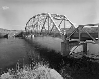
The Bighorn River is a tributary of the Yellowstone, approximately 461 miles (742 km) long, in the states of Wyoming and Montana in the western United States. The river was named in 1805 by fur trader François Larocque for the bighorn sheep he saw along its banks as he explored the Yellowstone.
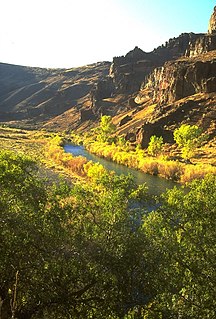
The Owyhee River is a tributary of the Snake River located in northern Nevada, southwestern Idaho and southeastern Oregon in the United States. It is 346 miles (557 km) long. The river's drainage basin is 11,049 square miles (28,620 km2) in area, one of the largest subbasins of the Columbia Basin. The mean annual discharge is 995 cubic feet per second (28.2 m3/s), with a maximum of 50,000 cu ft/s (1,400 m3/s) recorded in 1993 and a minimum of 42 cu ft/s (1.2 m3/s) in 1954.

Henrys Fork is a tributary river of the Snake River, approximately 127 miles (204 km) long, in southeastern Idaho in the United States. It is also referred to as the North Fork of the Snake River. Its drainage basin is 3,212 square miles (8,320 km2), including its main tributary, the Teton River. Its mean annual discharge, as measured at river mile 9.2 by the United States Geological Survey (USGS), is 2,096 cubic feet per second (59.4 m3/s), with a maximum daily recorded flow of 79,000 cubic feet per second (2,240 m3/s), and a minimum of 183 cubic feet per second (5.18 m3/s).

The Lewis River is an 18.1-mile-long (29.1 km) tributary of the Snake River. The entire course of the river is located within the boundaries of Yellowstone National Park in Wyoming, US. The river is named for Meriwether Lewis, commander of the Lewis and Clark Expedition.
The Snake River is a tributary of the Red River of the North in northwestern Minnesota in the United States. It is one of three streams in Minnesota with this name.

The Yellowstone cutthroat trout
is a subspecies of the cutthroat trout. It is a freshwater fish in the salmon family. Native only to a few U.S. states, their original range was upstream of Shoshone Falls on the Snake River and tributaries in Wyoming, also across the Continental Divide in Yellowstone Lake and in the Yellowstone River as well as its tributaries downstream to the Tongue River in Montana. The species is also found in Idaho, Utah and Nevada.

The Ottauquechee River is a 41.4-mile-long (66.6 km) river in eastern Vermont in the United States. It is a tributary of the Connecticut River, which flows to Long Island Sound.

The Raystown Branch Juniata River is the largest and longest tributary of the Juniata River in south-central Pennsylvania in the United States.

The Ontonagon River is a river flowing to Lake Superior on the western Upper Peninsula of Michigan in the United States. The main stem of the river is 25 miles (40 km) long and is formed by a confluence of several longer branches, portions of which have been collectively designated as a National Wild and Scenic River. Several waterfalls occur on the river including Agate Falls and Bond Falls.

There are two rivers in Idaho named "Lost", the Big Lost River and the Little Lost River. They are often considered separate streams, but both flow into the same depression and become subterranean, feeding the Snake River Aquifer. The rivers are located in Custer County and Butte County, in Idaho in the United States. Via the aquifer and numerous springs, they are tributaries of the Snake River.

The Sol Duc River is a river in the U.S. state of Washington. About 78 miles (126 km) long, it flows west through the northwest part of the Olympic Peninsula, from the Olympic Mountains of Olympic National Park and Olympic National Forest, then through the broad Sol Duc Valley. Near the Pacific Ocean the Sol Duc River joins the Bogachiel River, forming the Quillayute River, which flows about 4 miles (6.4 km) to the Pacific Ocean at La Push. Although the Quillayute River is short, its large tributary rivers—the Sol Duc, Bogachiel, Calawah, and Dickey Rivers—drain the largest watershed of the northern Olympic Peninsula, 629 square miles (1,630 km2). The Sol Duc's watershed is the largest of the Quillayute's tributaries, at 219 square miles (570 km2).

Succor Creek is a 69.4-mile-long (111.7 km) tributary of the Snake River in the U.S. states of Idaho and Oregon. The creek begins in the Owyhee Mountains in Owyhee County, Idaho. After flowing for about 23 miles (37 km) in Idaho, Succor Creek enters Malheur County, Oregon, where it flows for 39 miles (63 km) before re-entering Idaho for its final 5 miles (8.0 km). It joins the Snake near Homedale, about 413 river miles (665 km) from the larger river's confluence with the Columbia River.
Cache Creek is a small creek in Cotton County, Oklahoma and a tributary of the Red River. Cache Creek has a distance of 5.5 miles (8.85 km) from the Red River to the East Cache Creek and West Cache Creek basin. The East Cache Creek and West Cache Creek confluence is located 6 miles (9.75 km) southwest of Temple, Oklahoma.

The Clearwater River is in the northwestern United States, in north central Idaho. Its length is 74.8 miles (120.4 km), it flows westward from the Bitterroot Mountains along the Idaho-Montana border, and joins the Snake River at Lewiston. In October 1805, the Lewis and Clark Expedition descended the Clearwater River in dugout canoes, putting in at "Canoe Camp," five miles (8 km) downstream from Orofino; they reached the Columbia Bar and the Pacific Ocean about six weeks later.

Lewis Lake is located in the U. S. state of Wyoming in the southern part of Yellowstone National Park, about 4 miles (6.4 km) southeast of Shoshone Lake, and approximately 10 miles (16 km) southwest of Yellowstone Lake. Lewis Lake and Shoshone Lake are both located a few miles northeast of the Pitchstone Plateau.

Shoshone Lake is a U.S. backcountry lake with the area of 8,050 acres elevated at 7,795 feet (2,376 m) in the southwest section of Yellowstone National Park, Wyoming. It lies at the headwaters of the Lewis River a tributary of the Snake River. The U.S. Fish and Wildlife Service believes that Shoshone Lake is the largest backcountry lake in the lower 48 states that cannot be reached by a road.

Heart Lake el. 7,461 feet (2,274 m) is a large backcountry lake, nestled at the base of Mount Sheridan in Yellowstone National Park. Heart Lake is in the Snake River drainage and is drained by the Heart River.

Mount Sheridan el. 10,313 feet (3,143 m) is a prominent mountain peak overlooking Heart Lake in the Red Mountains of Yellowstone National Park. The peak is named in honor of General Philip H. Sheridan, U.S. Army, one of the early protectors of the park.

Fall River rises on the Madison and Pitchstone plateaus in the southwest corner of Yellowstone National Park, Wyoming and flows approximately 64 miles (103 km) to its confluence with the Henrys Fork of the Snake River near Ashton, Idaho. Historically, the river was referred to as the Middle Fork of the Snake River or as Fall River or the Falls River by trappers and prospectors as early as the 1830s. It was officially named the Falls River by the 1872 Hayden Geological Survey, but was always called Fall River by the locals and so the U.S. Board on Geographic Names changed the official name to Fall River in 1997 at the request of Idaho authorities. The river is home to numerous waterfalls and cascades in its upper reaches.

Mount Hancock el. 10,223 feet (3,116 m) is an isolated mountain peak on Big Game Ridge in Yellowstone National Park. Captain John W. Barlow named the peak in honor of General Winfield Scott Hancock during the Barlow-Heap Exploration of Yellowstone in 1871. General Hancock is noted for issuing the orders that established the military escort led by Lt. Gustavus Cheyney Doane for the Washburn–Langford–Doane Expedition of 1870.


