Carbon County, Wyoming

Last updated

Carbon County
Carbon County Courthouse Wyoming 5-3-2014.jpg
Carbon County Courthouse in Rawlins
Flag of Carbon County, Wyoming.gif
Map of Wyoming highlighting Carbon County.svg
Location within the U.S. state of Wyoming
Wyoming in United States.svg
Wyoming's location within the U.S.
Coordinates: 41°41′N106°56′W / 41.69°N 106.93°W / 41.69; -106.93
CountryFlag of the United States.svg United States
StateFlag of Wyoming.svg  Wyoming
FoundedDecember 16, 1868
Named for Coal deposits
Seat Rawlins
Largest cityRawlins
Area
  Total7,964 sq mi (20,630 km2)
  Land7,898 sq mi (20,460 km2)
  Water66 sq mi (170 km2)  0.8%
Population
 (2020)
  Total14,537
  Density1.8/sq mi (0.70/km2)
Time zone UTC−7 (Mountain)
  Summer (DST) UTC−6 (MDT)
Congressional district At-large
Website www.carbonwy.com
George Ferris Mansion, Rawlins Ferris Mansion Rawlins Wyoming.jpeg
George Ferris Mansion, Rawlins
Pick Bridge over the North Platte River, near Saratoga. Listed on the National Register of Historic Places. DMJ Pick Bridge.jpg
Pick Bridge over the North Platte River, near Saratoga. Listed on the National Register of Historic Places.
Canoers on the North Platte River, Northgate Canyon North Platte River Northgate Canyon Canoers.jpg
Canoers on the North Platte River, Northgate Canyon

Carbon County is a county in the U.S. state of Wyoming. As of the 2020 United States Census, the population was 14,537. [1] Its county seat is Rawlins. [2] Its south border abuts the north line of Colorado.

Contents

History

Carbon County was organized in 1868, one of the five original counties in Dakota Territory. [3]

Originally about 3,400 square miles (8,800 km2) near the center of Wyoming, Carbon County was once part of the Spanish Empire, then part of the Republic of Texas (1835-1845) and part of the State of Texas until 1852 when the northernmost part of that state's claims were ceded to the US government. This area is defined by the 42nd parallel on the north, and straight lines south from there to the headwaters of the Arkansas river on the east and the headwaters of the Rio Grande on the west. The documents defining that area include the Adams-Onís Treaty of 1819, the 1824 Constitution of Mexico, and the 1845 "Joint Resolution for the Admission of the State of Texas into the Union" Archived December 31, 2006, at the Wayback Machine .

Carbon County was organized December 16, 1868, from Laramie County in Dakota Territory, which at the time had jurisdiction over part of modern-day Wyoming. [4] It became a county in Wyoming Territory when that territory's government was formally organized on May 19, 1869. [5] [6]

In 1868, the Union Pacific Railroad opened the first coal mine in Carbon County, and the county was named for its extensive coal deposits. [7] In 1875, Carbon County lost territory when Johnson County was created by the legislature of the Wyoming Territory. Natrona County was created with land ceded by Carbon County in 1888. The boundaries of the county were final at that time except for minor adjustments in 1911.

From 1978 to 1982, Carbon County was represented in the Wyoming House of Representatives by Democrat Thomas E. Trowbridge (1930-2009) of Saratoga, a Nebraska native. From 1982 to 1986, Trowbridge was a member of the Wyoming State Senate. He was later appointed by Governor Mike Sullivan to the Wyoming State Board of Equalization. Trowbridge's father, Elton Trowbridge, held the state House seat from Carbon County from 1961 until his death in office in 1974.

George R. Salisbury Jr., a rancher from Savery, represented Carbon County in the Wyoming House from 1975 to 1986. He was succeeded in office by his son-in-law and fellow Democrat, Patrick F. O'Toole, also a Savery rancher.

Geography

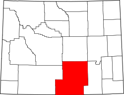
According to the US Census Bureau, the county has a total area of 7,964 square miles (20,630 km2), of which 7,898 square miles (20,460 km2) is land and 66 square miles (170 km2) (2.0%) is water. [8] It is the third-largest county in Wyoming by area.

The Continental Divide runs through the county.

Major highways

Adjacent counties

National protected areas and State historical sites

Demographics

Historical population
CensusPop.Note
1870 1,368
1880 3,438151.3%
1890 6,85799.4%
1900 9,58939.8%
1910 11,28217.7%
1920 9,525−15.6%
1930 11,39119.6%
1940 12,64411.0%
1950 15,74224.5%
1960 14,937−5.1%
1970 13,354−10.6%
1980 21,89664.0%
1990 16,659−23.9%
2000 15,639−6.1%
2010 15,8851.6%
2020 14,537−8.5%
2023 (est.)14,334 [10] −1.4%
US Decennial Census [11]
1870–2000 [12] 2010–2016 [1]

Census-designated places

2000 census

As of the 2000 United States Census, [13] there were 15,639 people, 6,129 households, and 4,130 families in the county. The population density was 2 people per square mile (0.77 people/km2). There were 8,307 housing units at an average density of 1 units per square mile (0.39 units/km2). The racial makeup of the county was 90.11% White, 0.67% African-American or Black, 1.27% Indigenous American, 0.67% Asian, 0.06% Pacific Islander, 5.17% from other races, and 2.05% from two or more races. 13.83% of the population were Hispanic or Latino of any race. 20.1% were of German, 11.8% English, 10.0% Irish and 8.9% American ancestry.

There were 6,129 households, out of which 31.20% had children under the age of 18 living with them, 55.10% were married couples living together, 8.30% had a female householder with no husband present, and 32.60% were non-families. Of 6,129 households, 364 were unmarried partner households: 318 heterosexual, 41 same-sex male, and 5 same-sex female.

27.50% of all households were made up of individuals, and 9.60% had someone living alone who was 65 years of age or older. The average household size was 2.39 and the average family size was 2.91.

The county population contained 24.10% under the age of 18, 8.60% from 18 to 24, 28.40% from 25 to 44, 26.70% from 45 to 64, and 12.30% who were 65 years of age or older. The median age was 39 years. For every 100 females there were 115.30 males. For every 100 females age 18 and over, there were 118.10 males.

The median income for a household in the county was $36,060, and the median income for a family was $41,991. Males had a median income of $31,603 versus $21,451 for females. The per capita income for the county was $18,375. About 9.80% of families and 12.90% of the population were below the poverty line, including 16.60% of those under age 18 and 14.80% of those age 65 or over.

2010 census

As of the 2010 United States Census, there were 15,885 people, 6,388 households, and 4,109 families in the county. [14] The population density was 2.0 people per square mile (0.77 people/km2). There were 8,576 housing units at an average density of 1.1 units per square mile (0.42 units/km2). [15] The racial makeup of the county was 88.8% white, 1.0% American Indian, 0.7% black or African American, 0.7% Asian, 0.1% Pacific islander, 6.5% from other races, and 2.2% from two or more races. Those of Hispanic or Latino origin made up 16.8% of the population. [14] In terms of ancestry, 26.0% were German, 15.8% were English, 14.4% were Irish, 5.6% were Scottish, and 4.8% were American. [16]

Of the 6,388 households, 30.8% had children under the age of 18 living with them, 51.5% were married couples living together, 7.8% had a female householder with no husband present, 35.7% were non-families, and 29.6% of all households were made up of individuals. The average household size was 2.36 and the average family size was 2.91. The median age was 38.9 years. [14]

The median income for a household in the county was $56,565 and the median income for a family was $65,171. Males had a median income of $51,201 versus $32,603 for females. The per capita income for the county was $26,122. About 5.6% of families and 8.2% of the population were below the poverty line, including 9.6% of those under age 18 and 9.6% of those age 65 or over. [17]

Government and infrastructure

During the twentieth century, owing to its considerable unionized mining population, Carbon County tended to be much more Democratic than the rest of generally Republican Wyoming. It was one of three Wyoming counties to vote for John F. Kennedy in 1960 and one of two to vote for Hubert Humphrey in 1968, while Dwight D. Eisenhower only won the county narrowly in his two landslide Presidential wins. In recent years, the county has trended much more towards the Republican Party due to changing demographics in the area.

United States presidential election results for Carbon County, Wyoming [18]
Year Republican Democratic Third party
No.%No.%No.%
2020 5,01475.24%1,42721.41%2233.35%
2016 4,40969.17%1,27920.07%68610.76%
2012 4,14863.73%2,11032.42%2513.86%
2008 4,33163.19%2,33634.08%1872.73%
2004 4,75867.23%2,15830.49%1612.27%
2000 4,49864.55%2,20631.66%2643.79%
1996 2,93044.96%2,69041.28%89713.76%
1992 2,32034.74%2,73740.99%1,62124.27%
1988 3,33655.70%2,55542.66%981.64%
1984 4,55765.55%2,29533.01%1001.44%
1980 4,33759.55%2,27231.20%6749.25%
1976 3,55654.01%3,01045.72%180.27%
1972 4,03763.69%2,29236.16%100.16%
1968 2,53244.77%2,72548.18%3997.05%
1964 2,16033.32%4,32266.68%00.00%
1960 3,14745.12%3,82854.88%00.00%
1956 3,33650.90%3,21849.10%00.00%
1952 3,40351.09%3,24248.67%160.24%
1948 2,31939.89%3,43959.16%550.95%
1944 2,69847.49%2,98352.51%00.00%
1940 2,88245.60%3,42954.26%90.14%
1936 2,04137.99%3,25760.62%751.40%
1932 2,08841.16%2,83655.90%1492.94%
1928 3,01964.85%1,60934.56%270.58%
1924 2,39854.56%73316.68%1,26428.76%
1920 1,87160.65%1,03933.68%1755.67%
1916 1,21739.99%1,66154.58%1655.42%
1912 1,10639.15%95733.88%76226.97%
1908 1,65151.56%1,43044.66%1213.78%
1904 2,23468.34%95629.24%792.42%
1900 1,75760.40%1,15239.60%00.00%
1896 1,22953.02%1,08046.59%90.39%
1892 97852.27%00.00%89347.73%

The Wyoming State Penitentiary, operated by the Wyoming Department of Corrections, is located in Rawlins. [19] The facility was operated by the Wyoming Board of Charities and Reform until that agency was dissolved as a result of a state constitutional amendment passed in November 1990. [20]

Communities

City

Towns

Unincorporated communities

Fort Steele

See also

Related Research Articles

<span class="mw-page-title-main">Johnson County, Wyoming</span> County in Wyoming, United States

Johnson County is a county in the north central part of the U.S. state of Wyoming. At the 2020 United States Census, the population was 8,447. The county seat is Buffalo. Kaycee is the only other incorporated town in the county.

<span class="mw-page-title-main">Weston County, Wyoming</span> County in Wyoming, United States

Weston County is a county in the U.S. state of Wyoming. As of the 2020 United States Census, the population was 6,838. Its county seat is Newcastle. Its east boundary line abuts the west line of the state of South Dakota.

<span class="mw-page-title-main">Sweetwater County, Wyoming</span> County in Wyoming, United States

Sweetwater County is a county in southwestern Wyoming, United States. As of the 2020 United States Census, the population was 42,272, making it the fourth-most populous county in Wyoming. Its county seat is Green River. By area, it is the largest county in Wyoming. Its southern boundary line abuts the north lines of the states of Colorado and Utah.

<span class="mw-page-title-main">Sheridan County, Wyoming</span> County in Wyoming, United States

Sheridan County is a county in the U.S. state of Wyoming. As of the 2020 United States Census, the population was 30,921. The county seat is Sheridan. Its northern boundary abuts the Montana state border.

<span class="mw-page-title-main">Platte County, Wyoming</span> County in Wyoming, United States

Platte County is a county located in the U.S. state of Wyoming. As of the 2020 United States Census, the population was 8,605. Its county seat is Wheatland.

<span class="mw-page-title-main">Park County, Wyoming</span> County in Wyoming, United States

Park County is a county in the U.S. state of Wyoming. As of the 2020 United States Census, the population was 29,624. The county seat is Cody.

<span class="mw-page-title-main">Niobrara County, Wyoming</span> County in the United States

Niobrara County is a county in the U.S. state of Wyoming. As of the 2020 United States Census, the population was 2,467, making it the least populous county in Wyoming. Its county seat is Lusk. Its eastern boundary abuts the west lines of the states of Nebraska and South Dakota.

<span class="mw-page-title-main">Natrona County, Wyoming</span> County in Wyoming, United States

Natrona County is a county in the U.S. state of Wyoming. As of the 2020 United States Census, the population was 79,955, making it the second-most populous county in Wyoming. Its county seat is Casper.

<span class="mw-page-title-main">Laramie County, Wyoming</span> County in Wyoming, United States

Laramie County is a county located at the southeast corner of the state of Wyoming. As of the 2020 United States Census, the population was 100,512 or 17.4% of the state's total 2020 population, making it the most populous county in Wyoming, but the least populous county in the United States to be the most populous in its state.

<span class="mw-page-title-main">Goshen County, Wyoming</span> County in Wyoming, United States

Goshen County is a county in the U.S. state of Wyoming. As of the 2020 United States Census, the population was 12,498. Its county seat is Torrington. The eastern boundary of the County borders the Nebraska state line.

<span class="mw-page-title-main">Fremont County, Wyoming</span> County in Wyoming, United States

Fremont County is a county in the U.S. state of Wyoming. As of the 2020 United States census, the population was 39,234, making it the fifth-most populous county in Wyoming. Its county seat is Lander. The county was founded in 1884 and is named for John C. Frémont, a general, explorer, and politician. It is roughly the size of the state of Vermont.

<span class="mw-page-title-main">Crook County, Wyoming</span> County in Wyoming, United States

Crook County is a county in the northeastern corner of the U.S. state of Wyoming. As of the 2020 United States Census, the population was 7,181, making it the third-least populous county in Wyoming. Its county seat is Sundance. The county is located at the northwestern extreme of the Black Hills, which are its defining geographical feature.

<span class="mw-page-title-main">Converse County, Wyoming</span> County in Wyoming, United States

Converse County is a county located in the U.S. state of Wyoming. As of the 2020 United States Census, the population was 13,751. Its county seat is Douglas.

<span class="mw-page-title-main">Campbell County, Wyoming</span> County in Wyoming, United States

Campbell County is a county in the U.S. state of Wyoming. As of the 2020 United States Census, the population was 47,026, making it the third-most populous county in Wyoming. Its county seat is Gillette.

<span class="mw-page-title-main">Big Horn County, Wyoming</span> County in Wyoming, United States

Big Horn County is a county in the U.S. state of Wyoming. As of the 2020 United States Census, the population was 11,521. The county seat is Basin. Its north boundary abuts the south boundary of Montana.

<span class="mw-page-title-main">Albany County, Wyoming</span> County in Wyoming, United States

Albany County is a county in the U.S. state of Wyoming. As of the 2020 United States Census, the population was 37,066. Its county seat is Laramie, the site of the University of Wyoming. Its south border lies on the northern Colorado state line.

<span class="mw-page-title-main">Lawrence County, South Dakota</span> County in South Dakota, United States

Lawrence County is a county in the U.S. state of South Dakota. As of the 2020 census, the population was 25,768, making it the 8th most populous county in South Dakota. Its county seat is Deadwood.

<span class="mw-page-title-main">Custer County, South Dakota</span> County in South Dakota, United States

Custer County is a county in the U.S. state of South Dakota. As of the 2020 census, the population was 8,318. Its county seat is Custer. The county was created in 1875, and was organized in 1877.

<span class="mw-page-title-main">Baggs, Wyoming</span> Town in Wyoming, United States

Baggs is a town in Carbon County, Wyoming, United States. The population was 411 at the 2020 census. Baggs is home to the Outlaw Stop, a branch of the Little Snake River Museum, which is headquartered in Savery.

<span class="mw-page-title-main">Worland, Wyoming</span> City in Wyoming, United States

Worland is a city in Washakie County, Wyoming, United States. The population was 5,487 at the 2010 census. It is the county seat of Washakie County. It is located within the Big Horn Basin and along the Big Horn River in northwestern Wyoming.

References

  1. 1 2 "State & County QuickFacts". US Census Bureau. Archived from the original on August 6, 2011. Retrieved January 25, 2014.
  2. "Find a County". National Association of Counties. Archived from the original on May 31, 2011. Retrieved June 7, 2011.
  3. The other four original counties: Albany; Laramie; Sweetwater; and Uinta.
  4. General Laws and Memorials and Resolutions of the Territory of Dakota, 1869 at Google Books
  5. Long, John H. (2006). "Wyoming: Individual County Chronologies". Wyoming Atlas of Historical County Boundaries. The Newberry Library. Archived from the original on July 18, 2011. Retrieved January 31, 2008.
  6. Long, John H. (2006). "Dakota Territory, South Dakota, and North Dakota: Individual County Chronologies". Dakota Territory Atlas of Historical County Boundaries. The Newberry Library. Archived from the original on November 12, 2007. Retrieved January 31, 2008.
  7. Urbanek, Mae (1988). Wyoming Place Names. Missoula MT: Mountain Press Pub. Co. ISBN   0-87842-204-8.
  8. "2010 Census Gazetteer Files". US Census Bureau. August 22, 2012. Retrieved August 5, 2015.
  9. Fort Steele WY Google Maps (accessed 9 January 2019)
  10. "Annual Estimates of the Resident Population for Counties: April 1, 2020 to July 1, 2023". United States Census Bureau. Retrieved March 24, 2024.
  11. "US Decennial Census". US Census Bureau. Retrieved August 5, 2015.
  12. "Historical Decennial Census Population for Wyoming Counties, Cities, and Towns". Wyoming Department of Administration & Information, Division of Economic Analysis. Retrieved January 25, 2014.
  13. "U.S. Census website". US Census Bureau. Retrieved May 14, 2011.
  14. 1 2 3 "Profile of General Population and Housing Characteristics: 2010 Demographic Profile Data". US Census Bureau. Archived from the original on February 13, 2020. Retrieved January 12, 2016.
  15. "Population, Housing Units, Area, and Density: 2010 - County". US Census Bureau. Archived from the original on February 13, 2020. Retrieved January 12, 2016.
  16. "Selected Social Characteristics in the US – 2006-2010 American Community Survey 5-Year Estimates". US Census Bureau. Archived from the original on February 13, 2020. Retrieved January 12, 2016.
  17. "Selected Economic Characteristics – 2006-2010 American Community Survey 5-Year Estimates". US Census Bureau. Archived from the original on February 13, 2020. Retrieved January 12, 2016.
  18. Leip, David. "Atlas of US Presidential Elections". uselectionatlas.org. Retrieved April 5, 2018.
  19. Contact Institutions. Wyoming Department of Corrections. Retrieved on August 22, 2010.
  20. About the Department of Corrections. Wyoming Department of Corrections. Retrieved on August 22, 2010.
  21. Leo WY Google Maps (accessed 9 January 2019)
  22. McFadden WY Google Maps (accessed 9 January 2019)
  23. Muddy Gap WY Google Maps (accessed 9 January 2019)
  24. Woodedge WY Google Maps (accessed 9 January 2019)

Further reading

41°41′N106°56′W / 41.69°N 106.93°W / 41.69; -106.93