McFadden, Wyoming

Last updated
McFadden, Wyoming
USA Wyoming location map.svg
Red pog.svg
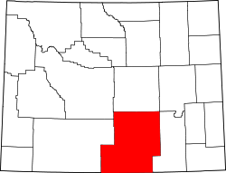
McFadden
Location within the state of Wyoming
Usa edcp location map.svg
Red pog.svg
McFadden
McFadden (the United States)
Coordinates: 41°39′16″N106°7′50″W / 41.65444°N 106.13056°W / 41.65444; -106.13056
Country United States
State Wyoming
County Carbon
Elevation
7,627 ft (2,325 m)
Time zone UTC-7 (Mountain (MST))
  Summer (DST) UTC-6 (MDT)
ZIP codes
82083
GNIS feature ID1609123 [1]

McFadden is an unincorporated community along Rock Creek near the eastern edge of Carbon County, Wyoming, United States. [1] The community was originally known as Ohio City. [1]

Contents

Description

The community lies along Wyoming Highway 13 (which connects Interstate 80 in Arlington on the southwest with the concurrency U.S. Route 30 and U.S. Route 287 on the northeast, just north Rock River). [2] Its elevation is 7,267 feet (2,215 m). [1]

While the community had a post office from 1921 to 1996, [3] it still retains its own ZIP Code of 82083. [4]

See also

Flag of Wyoming.svg Wyomingportal

References

  1. 1 2 3 4 U.S. Geological Survey Geographic Names Information System: McFadden
  2. "McFadden, Wyoming 82083" (Map). Google Maps . Retrieved June 22, 2025.
  3. Forte, Jim. "Post Offices: Wyoming: Carbon County". postalhistory.com. Retrieved June 22, 2025.
  4. "Look Up a ZIP Code: ZIP Code by City and State". usps.com. United States Postal Service . Retrieved June 22, 2025.