
Nebraska Highway 13 is a highway in the northeastern part of the U.S. state of Nebraska that runs predominantly northwest-southeast with a south terminus east of Hadar at an intersection with U.S. Highway 81 and a north terminus two miles (3 km) south of Center, Nebraska at an intersection with Nebraska Highway 84.

Nebraska Highway 133 is a highway in eastern Nebraska. Its southern terminus is at an intersection with U.S. Highway 6 in Omaha. Its northern terminus is at an intersection with U.S. Highway 30 in Blair.

Nebraska Highway 4 is a highway in Nebraska. The entirety of the route is in Nebraska's southern tier of counties. Beatrice is the only city with over 1,000 in population on the highway. Its western terminus is at an intersection with US 6 and US 34 southwest of Atlanta. Its eastern terminus is at an intersection with US 75 north of Dawson.

Nebraska Highway 9 is a highway in northeastern Nebraska. The southern terminus is located just north of West Point at an intersection with U.S. Highway 275. Its northern terminus is at an intersection with Nebraska Highway 12 just south of Ponca.

Nebraska Highway 12 is a highway in northern and northeastern Nebraska. It has a western terminus at U.S. Highway 83 in Valentine and an eastern terminus at U.S. Highway 20 west of Jackson. The highway largely lies within 10 miles (16 km) of the South Dakota border its entire length. The highway has been designated the Outlaw Trail Scenic Byway.
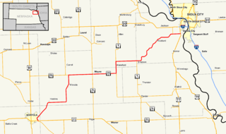
Nebraska Highway 35 is a highway in the northeastern part of the U.S. state of Nebraska. It has a western terminus in Norfolk at U.S. Highway 275 and Nebraska Highway 24 and an eastern terminus at U.S. Highway 77 and U.S. Highway 75 at Dakota City. The highway serves as a connector between Norfolk and Sioux City, Iowa.

Nebraska Highway 85 is a highway in Nebraska. It is a highway in the Omaha Metro Area. It has a southern terminus at Nebraska Highway 370 in Papillion. Its northern terminus is at U.S. Highway 275 and Nebraska Highway 92 on the border of Omaha and Ralston. It is a four-lane highway for its entire length. Most people in the Omaha area think of the highway as part of 84th Street.

Nebraska Highway 64 is a highway in Nebraska. There are two segments to the highway. The western segment lies in Butler County between U.S. Highway 81 and Nebraska Highway 15. The eastern segment goes through Saunders and Douglas counties between U.S. Highway 77 and U.S. Highway 75.

Nebraska Highway 68 is a highway in central Nebraska. Its western terminus is at an intersection with Nebraska Highway 2 just south of Ravenna. Its eastern terminus is at an intersection with Nebraska Highway 58 in Rockville.

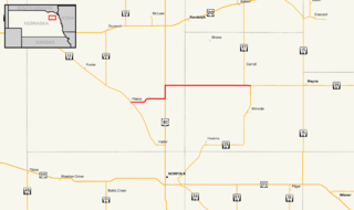
Nebraska Highway 84 is a highway in the northeastern part of the U.S. state of Nebraska. Its western terminus is at Nebraska Highway 14 in Verdigre. Its eastern terminus is at an intersection with Nebraska Highway 15 east of Hartington.

Nebraska Highway 87 is a highway in northwestern Nebraska. It has a southern terminus at Nebraska Highway 2 in Alliance. Its northern terminus is at the South Dakota border where it continues in northward as South Dakota Highway 407.

Nebraska Highway 95 is a highway in northeastern Nebraska. It has a western terminus at an intersection with Nebraska Highway 11 west of Chambers. Its eastern terminus is at U.S. Highway 281 to the east of Chambers.
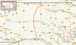
Nebraska Highway 97 is a highway in western Nebraska. It has a southern terminus north of North Platte at an intersection with U.S. Highway 83. The northern terminus is at U.S. Highway 20 in Valentine.
Nebraska Highway 98 is a highway in the northeastern part of the U.S. state of Nebraska. Its western terminus is at an intersection with Nebraska Highway 13 in Pierce. Its eastern terminus is at an intersection with Nebraska Highway 35 west of Wayne.
Nebraska Highway 89 is a highway in southern Nebraska. Its western terminus is at U.S. Highway 83 west of Danbury. Its eastern terminus is at an intersection with U.S. Highway 183 south of Alma.

Nebraska Highway 78 is a highway in southern Nebraska. It has a southern terminus at the Kansas border where it continues from K-28. Its northern terminus is at an intersection with Nebraska Highway 4 west of Lawrence.

Nebraska Highway 91 is a highway in central and eastern Nebraska. Its western terminus is at an intersection with Nebraska Highway 2 north of Dunning. Its eastern terminus is at an intersection with U.S. Highway 30 and U.S. Highway 75 in Blair.

Nebraska Highway 66 is a highway in central and eastern Nebraska. It is a discontinuous highway with four segments heading in a west-to-east direction. The first segment begins at Nebraska Highway 14 south of Central City and ends at U.S. Highway 81 south of Stromsburg. The second segment begins at Nebraska Highway 15 west of Dwight and ends at Nebraska Highway 79 in Valparaiso. The third segment begins at U.S. Highway 77 south of Wahoo and ends at Main Street in Louisville. The fourth and final segment begins at the intersection with Walnut Street and Koop Avenue in Louisville, and ends at U.S. Highway 34 and U.S. Highway 75 west of Plattsmouth.

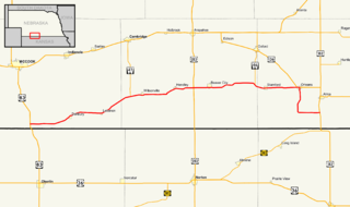
Nebraska Highway 70 is a highway in central Nebraska. Its western terminus is at an intersection with Nebraska Highway 2 and Nebraska Highway 92 east of Broken Bow. Its eastern terminus is at Nebraska Highway 14 in Elgin.

Nebraska Highway 74 is a highway in southern Nebraska. Its western terminus is at an intersection with Nebraska Highway 10 in Minden. Its eastern terminus is at an intersection with Nebraska Highway 15 east of Tobias.

