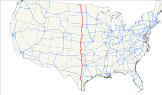
U.S. Route 281 (US 281) is a north–south United States Numbered Highway. At 1,875 miles (3,018 km) long it is the longest continuous three-digit U.S. Route.

Nebraska Highway 2 is a highway in Nebraska. It is a discontinuous highway with 2 segments. The western segment begins at the South Dakota border northwest of Crawford and ends southeast of Grand Island at an intersection with Interstate 80. The eastern segment begins in Lincoln and ends at the Iowa border at Nebraska City. Previously, the two segments were connected via a route shared with U.S. Highway 34 between Grand Island and Lincoln.

Nebraska Highway 4 is a highway in Nebraska. The entirety of the route is in Nebraska's southern tier of counties. Beatrice is the only city with over 1,000 in population on the highway. Its western terminus is at an intersection with US 6 and US 34 southwest of Atlanta. Its eastern terminus is at an intersection with US 75 north of Dawson.

Nebraska Highway 67 is a highway in southeastern Nebraska. Its southern terminus is at an intersection with U.S. Highway 73 near Verdon. Its northern terminus is at an intersection with U.S. Highway 34 near Nehawka. The segment between Nebraska Highway 2 and US 34 is one of four segments of road in the Nebraska highway system which is gravel.

Nebraska Highway 12 is a highway in northern and northeastern Nebraska. It has a western terminus at U.S. Highway 83 in Valentine and an eastern terminus at U.S. Highway 20 west of Jackson. The highway largely lies within 10 miles (16 km) of the South Dakota border its entire length. The highway has been designated the Outlaw Trail Scenic Byway.

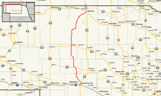
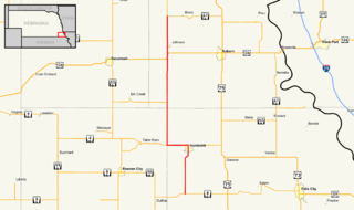
Nebraska Highway 58 is a highway in Nebraska. It has a length of 53 miles (85 km). Much of the route lies near the Loup River. The southern terminus is at an intersection with U.S. Highway 281 south of St. Paul. The northern terminus is at an intersection with Nebraska Highway 70 east of Arcadia.

Nebraska Highway 84 is a highway in the northeastern part of the U.S. state of Nebraska. Its western terminus is at Nebraska Highway 14 in Verdigre. Its eastern terminus is at an intersection with Nebraska Highway 15 east of Hartington.
Nebraska Highway 97 is a highway in western Nebraska. It has a southern terminus north of North Platte at an intersection with U.S. Highway 83. The northern terminus is at U.S. Highway 20 in Valentine.
Nebraska Highway 98 is a highway in the northeastern part of the U.S. state of Nebraska. Its western terminus is at an intersection with Nebraska Highway 13 in Pierce. Its eastern terminus is at an intersection with Nebraska Highway 35 west of Wayne.
Nebraska Highway 89 is a highway in southern Nebraska. Its western terminus is at U.S. Highway 83 west of Danbury. Its eastern terminus is at an intersection with U.S. Highway 183 south of Alma.

Nebraska Highway 137 is a highway in northern Nebraska. Its southern terminus is at U.S. Highway 20 in Newport. Its northern terminus is at the South Dakota border where it continues as South Dakota Highway 47.

Nebraska Highway 103 is a highway in southeastern Nebraska. It is a discontinuous highway with two segments. The southern segment begins at Nebraska Highway 8 south of Diller and ends at U.S. Highway 136 north of Diller. The northern segment begins at Nebraska Highway 4 east of Plymouth and ends at Interstate 80 north of Pleasant Dale.
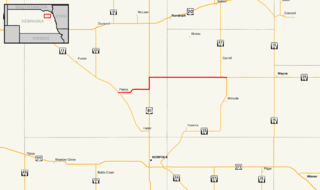
Nebraska Highway 105 is a highway in southeastern Nebraska. Its southern terminus is at an intersection with Nebraska Highway 8 south of Humboldt. Its northern terminus is at an intersection with Nebraska Highway 67 west of Brock.

Nebraska Highway 121 is a highway in northeastern Nebraska. It is a discontinuous highway with three segments:

Nebraska Highway 91 is a highway in central and eastern Nebraska. Its western terminus is at an intersection with Nebraska Highway 2 north of Dunning. Its eastern terminus is at an intersection with U.S. Highway 30 and U.S. Highway 75 in Blair.

Nebraska Highway 66 is a highway in central and eastern Nebraska. It is a discontinuous highway with four segments heading in a west-to-east direction. The first segment begins at Nebraska Highway 14 south of Central City and ends at U.S. Highway 81 south of Stromsburg. The second segment begins at Nebraska Highway 15 west of Dwight and ends at Nebraska Highway 79 in Valparaiso. The third segment begins at U.S. Highway 77 south of Wahoo and ends at Main Street in Louisville. The fourth and final segment begins at the intersection with Walnut Street and Koop Avenue in Louisville, and ends at U.S. Highway 34 and U.S. Highway 75 west of Plattsmouth.

Nebraska Highway 71 is a highway in western Nebraska. Its southern terminus is at the Colorado border south of Kimball, as a continuation of Colorado State Highway 71. Its northern terminus is at the South Dakota border northwest of Crawford, where it continues as South Dakota Highway 71.

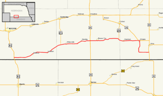
Nebraska Highway 74 is a highway in southern Nebraska. Its western terminus is at an intersection with Nebraska Highway 10 in Minden. Its eastern terminus is at an intersection with Nebraska Highway 15 east of Tobias.
U.S. Route 70 is a transcontinental U.S. highway extending from Globe, Arizona to Atlantic, North Carolina. Along the way, 289.81 miles (466.40 km) of its route passes through the state of Oklahoma. Entering the state south of Davidson, the highway serves Oklahoma's southern tier before exiting the state east of Broken Bow. It serves the cities of Ardmore, Durant, Hugo, and Idabel, as well as Tillman, Cotton, Jefferson, Carter, Marshall, Bryan, Choctaw, and McCurtain counties.
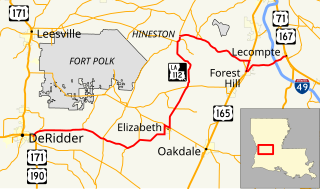
Louisiana Highway 112 is a state highway in Louisiana. It spans 80.9 miles (130.2 km) and runs from west to east. LA 112 is a mostly rural two lane highway with a maximum speed limit of 55 miles per hour (89 km/h) per hour. The western terminus is at an intersection with U.S. Route 171/U.S. Route 190 in Beauregard Parish and the eastern terminus at an intersection with US 167/US 71 in Rapides Parish. Although the highway runs west to east it meanders through three parishes and on the map appears to make a large S.

