
Nebraska Highway 2 is a state highway in Nebraska consisting of two discontinuous segments. The western segment begins at the South Dakota border northwest of Crawford and ends southeast of Grand Island at an intersection with Interstate 80. The eastern segment begins in Lincoln and ends at the Iowa border at Nebraska City. Previously, the two segments were connected via a route shared with U.S. Highway 34 between Grand Island and Lincoln.

Nebraska Highway 4 is a highway in Nebraska. The entirety of the route is in Nebraska's southern tier of counties. Beatrice is the only city with over 1,000 in population on the highway. Its western terminus is at an intersection with US 6 and US 34 southwest of Atlanta. Its eastern terminus is at an intersection with US 75 north of Dawson.
Nebraska Highway 63 is a north–south highway in eastern Nebraska with a length of 13.93 miles (22.42 km). It is also known throughout Cass County as 238th Street, except in the village of Alvo, where it adopts the name Russell Street. Its southern terminus is at U.S. Highway 34 east of Eagle. Its northern terminus is at U.S. Highway 6 southwest of Ashland.

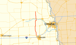
Nebraska Highway 67 is a highway in southeastern Nebraska. Its southern terminus is at an intersection with U.S. Highway 73 near Verdon. Its northern terminus is at an intersection with U.S. Highway 34 near Nehawka. The segment between Nebraska Highway 2 and US 34 is one of four segments of road in the Nebraska highway system which is gravel.

Nebraska Highway 7 is a highway in Nebraska. Its southern terminus is at Nebraska Highway 91 in Brewster. Its northern terminus is at U.S. Highway 183 near Springview.

Nebraska Highway 8 (N-8) is a highway in southern and southeastern Nebraska. Its western terminus is at Nebraska Highway 14 in Superior and its eastern terminus is at U.S. Highway 73 (US 73) in Falls City. It runs through the southern tier of counties in Nebraska and is always within 10 miles (16 km) of the Kansas border.

Nebraska Highway 12 is a highway in northern and northeastern Nebraska. It has a western terminus at U.S. Highway 83 in Valentine and an eastern terminus at U.S. Highway 20 west of Jackson. The highway largely lies within 10 miles (16 km) of the South Dakota border its entire length. The highway has been designated the Outlaw Trail Scenic Byway.

Nebraska Highway 14 (N-14) is a highway in the U.S. state of Nebraska. It has a southern terminus at the Kansas border, where it continues south as K-14, southwest of Superior and a northern terminus east of Niobrara at the South Dakota border.

Nebraska Highway 15 (N-15) is a highway in eastern Nebraska, United States. It has a southern terminus at the Kansas border south of Fairbury and a northern terminus northeast of Maskell at the South Dakota border.

Nebraska Highway 64 is a highway in Nebraska. There are two segments to the highway. The western segment lies in Butler County between U.S. Highway 81 and Nebraska Highway 15. The eastern segment goes through Saunders and Douglas counties between U.S. Highway 77 and U.S. Highway 75.

Nebraska Highway 21 is a highway in central Nebraska. Its southern terminus is at Nebraska Highway 23 east of Eustis. Its northern terminus is at an intersection with Nebraska Highway 2 and Nebraska Highway 92 in Broken Bow.

Nebraska Highway 23 is a 159.91-mile (257.35 km) highway in southwestern Nebraska, United States. Its western terminus is on the Colorado border at Venango, where the highway continues west as Colorado State Highway 23. The eastern terminus of NE 23 is at Holdrege at an intersection with U.S. Routes 6 and 34.
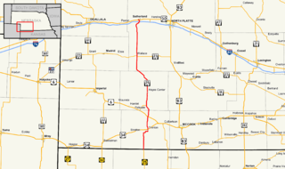
Nebraska Highway 25 is a highway in southwestern Nebraska. It runs for 87 miles (140 km). Its southern terminus is at the Kansas border south of Trenton. Its northern terminus is at U.S. Highway 30 in Sutherland.

Nebraska Highway 27 is a highway in Nebraska. It is divided into three segments. The southernmost segment begins at the Kansas border and goes north to Haigler. The middle segment begins at Interstate 80 near Chappell and goes north to Oshkosh. The northernmost segment begins at Ellsworth and goes north to the South Dakota border.
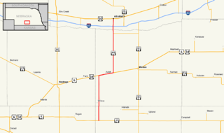
Nebraska Highway 44 (NE-44) is a 31.51-mile (50.71 km) highway in Franklin, Kearney, and Buffalo counties in Nebraska, United States. It runs in a south-to-north direction from Nebraska Highway 4 (NE-4) south of Wilcox to an intersection with U.S. Route 30 (US 30) in Kearney.
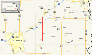
Nebraska Highway 79 is a highway in eastern Nebraska. It is a north–south highway which has a length of 60.28 miles (97.01 km). The southern terminus of Highway 79 is northwest of Lincoln near Lincoln Airport at U.S. Highway 34. The northern terminus of Highway 79 is in Snyder.

Nebraska Highway 61 is a highway in western Nebraska. It is a north–south highway with a length of 234.82 miles (377.91 km). The southern terminus of Nebraska Highway 61 is at the Kansas border south of Benkelman, where the highway continues south as K-161. The northern terminus is at the South Dakota border north of Merriman, where the highway continues north as South Dakota Highway 73.
Nebraska Highway 137 is a highway in northern Nebraska. Its southern terminus is at U.S. Highway 20 in Newport. Its northern terminus is at the South Dakota border where it continues as South Dakota Highway 47.

Nebraska Highway 70 is a highway in central Nebraska. Its western terminus is at an intersection with Nebraska Highway 2 and Nebraska Highway 92 east of Broken Bow. Its eastern terminus is at Nebraska Highway 14 in Elgin.

Nebraska Highway 71 is a highway in western Nebraska. Its southern terminus is at the Colorado border south of Kimball, as a continuation of Colorado State Highway 71. Its northern terminus is at the South Dakota border northwest of Crawford, where it continues as South Dakota Highway 71.


