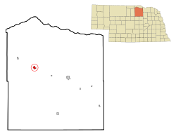
Atkinson, Nebraska | |
---|---|
Coordinates: 42°31′51″N98°58′29″W / 42.53083°N 98.97472°W | |
Country | United States |
State | Nebraska |
County | Holt |
Area | |
• Total | 1.64 sq mi (4.24 km2) |
• Land | 1.64 sq mi (4.24 km2) |
• Water | 0.00 sq mi (0.00 km2) |
Elevation | 2,106 ft (642 m) |
Population (2020) | |
• Total | 1,306 |
• Density | 798.29/sq mi (308.21/km2) |
Time zone | UTC-6 (Central (CST)) |
• Summer (DST) | UTC-5 (CDT) |
ZIP code | 68713 |
Area code | 402 |
FIPS code | 31-02550 [3] |
GNIS feature ID | 2394013 [2] |
Website | http://www.atkinsonne.com/ |
Atkinson is a city in Holt County, Nebraska, United States. The population was 1,306 at the 2020 census. [4]
The first settlement at Atkinson was made circa 1875. [5] Atkinson was platted in 1880, when the railroad was extended to that point. [6] It was named for Col. John Atkinson, an original owner of the town site. [7] [8]
According to the United States Census Bureau, the city has a total area of 1.63 square miles (4.22 km2), all land. [9]
Climate data for Atkinson 3SW, Nebraska (1991–2020 normals, extremes 1906–present) | |||||||||||||
---|---|---|---|---|---|---|---|---|---|---|---|---|---|
Month | Jan | Feb | Mar | Apr | May | Jun | Jul | Aug | Sep | Oct | Nov | Dec | Year |
Record high °F (°C) | 72 (22) | 77 (25) | 92 (33) | 98 (37) | 98 (37) | 107 (42) | 112 (44) | 109 (43) | 106 (41) | 99 (37) | 83 (28) | 73 (23) | 112 (44) |
Mean maximum °F (°C) | 58.4 (14.7) | 63.0 (17.2) | 74.8 (23.8) | 83.0 (28.3) | 89.1 (31.7) | 94.6 (34.8) | 100.1 (37.8) | 97.6 (36.4) | 93.2 (34.0) | 84.8 (29.3) | 72.7 (22.6) | 59.4 (15.2) | 100.1 (37.8) |
Mean daily maximum °F (°C) | 32.0 (0.0) | 35.3 (1.8) | 46.9 (8.3) | 57.7 (14.3) | 68.9 (20.5) | 79.5 (26.4) | 86.0 (30.0) | 83.5 (28.6) | 75.8 (24.3) | 61.3 (16.3) | 46.9 (8.3) | 34.2 (1.2) | 59.0 (15.0) |
Daily mean °F (°C) | 21.1 (−6.1) | 24.2 (−4.3) | 34.9 (1.6) | 45.8 (7.7) | 57.5 (14.2) | 68.0 (20.0) | 73.8 (23.2) | 71.4 (21.9) | 63.0 (17.2) | 48.6 (9.2) | 35.3 (1.8) | 24.1 (−4.4) | 47.3 (8.5) |
Mean daily minimum °F (°C) | 10.2 (−12.1) | 13.1 (−10.5) | 22.8 (−5.1) | 33.9 (1.1) | 46.1 (7.8) | 56.6 (13.7) | 61.7 (16.5) | 59.3 (15.2) | 50.2 (10.1) | 36.0 (2.2) | 23.7 (−4.6) | 13.9 (−10.1) | 35.6 (2.0) |
Mean minimum °F (°C) | −9.4 (−23.0) | −5.9 (−21.1) | 3.2 (−16.0) | 19.4 (−7.0) | 32.2 (0.1) | 45.7 (7.6) | 51.6 (10.9) | 48.9 (9.4) | 34.9 (1.6) | 20.2 (−6.6) | 5.7 (−14.6) | −5.4 (−20.8) | −14.8 (−26.0) |
Record low °F (°C) | −35 (−37) | −33 (−36) | −18 (−28) | −6 (−21) | 18 (−8) | 35 (2) | 41 (5) | 34 (1) | 14 (−10) | −1 (−18) | −18 (−28) | −29 (−34) | −35 (−37) |
Average precipitation inches (mm) | 0.40 (10) | 0.70 (18) | 1.26 (32) | 2.65 (67) | 4.31 (109) | 3.66 (93) | 2.57 (65) | 3.09 (78) | 2.64 (67) | 2.37 (60) | 0.71 (18) | 0.56 (14) | 24.92 (633) |
Average snowfall inches (cm) | 5.5 (14) | 6.7 (17) | 5.1 (13) | 4.1 (10) | 0.2 (0.51) | 0.0 (0.0) | 0.0 (0.0) | 0.0 (0.0) | 0.0 (0.0) | 1.5 (3.8) | 4.0 (10) | 6.2 (16) | 33.3 (85) |
Average precipitation days (≥ 0.01 in) | 3.5 | 4.1 | 5.2 | 8.3 | 11.3 | 10.9 | 9.0 | 8.2 | 6.9 | 6.2 | 3.7 | 3.7 | 81.0 |
Average snowy days (≥ 0.1 in) | 3.4 | 3.6 | 2.6 | 1.6 | 0.0 | 0.0 | 0.0 | 0.0 | 0.0 | 0.7 | 1.8 | 3.6 | 17.3 |
Source: NOAA [10] [11] |
Census | Pop. | Note | %± |
---|---|---|---|
1890 | 701 | — | |
1900 | 595 | −15.1% | |
1910 | 810 | 36.1% | |
1920 | 1,300 | 60.5% | |
1930 | 1,144 | −12.0% | |
1940 | 1,350 | 18.0% | |
1950 | 1,372 | 1.6% | |
1960 | 1,324 | −3.5% | |
1970 | 1,406 | 6.2% | |
1980 | 1,521 | 8.2% | |
1990 | 1,380 | −9.3% | |
2000 | 1,244 | −9.9% | |
2010 | 1,245 | 0.1% | |
2020 | 1,306 | 4.9% | |
U.S. Decennial Census [12] |
As of the census [13] of 2010, there were 1,245 people, 549 households, and 322 families living in the city. The population density was 763.8 inhabitants per square mile (294.9/km2). There were 638 housing units at an average density of 391.4 per square mile (151.1/km2). The racial makeup of the city was 98.8% White, 0.2% African American, 0.6% Native American, 0.1% Pacific Islander, 0.2% from other races, and 0.2% from two or more races. Hispanic or Latino of any race were 0.5% of the population.
There were 549 households, of which 25.5% had children under the age of 18 living with them, 49.7% were married couples living together, 6.4% had a female householder with no husband present, 2.6% had a male householder with no wife present, and 41.3% were non-families. 38.6% of all households were made up of individuals, and 22.4% had someone living alone who was 65 years of age or older. The average household size was 2.19 and the average family size was 2.92.
The median age in the city was 46.1 years. 23.2% of residents were under the age of 18; 4.7% were between the ages of 18 and 24; 20.7% were from 25 to 44; 26.8% were from 45 to 64; and 24.3% were 65 years of age or older. The gender makeup of the city was 46.6% male and 53.4% female.
As of the census [3] of 2000, there were 1,244 people, 537 households, and 322 families living in the city. The population density was 932.8 inhabitants per square mile (360.2/km2). There were 640 housing units at an average density of 479.9 per square mile (185.3/km2). The racial makeup of the city was 98.95% White, 0.08% African American, 0.08% Native American, 0.32% Asian, and 0.56% from two or more races. Hispanic or Latino of any race were 0.88% of the population.
There were 537 households, out of which 26.1% had children under the age of 18 living with them, 52.0% were married couples living together, 5.4% had a female householder with no husband present, and 40.0% were non-families. 36.7% of all households were made up of individuals, and 20.1% had someone living alone who was 65 years of age or older. The average household size was 2.20 and the average family size was 2.91.
In the city, the population was spread out, with 22.7% under the age of 18, 5.6% from 18 to 24, 23.4% from 25 to 44, 22.7% from 45 to 64, and 25.5% who were 65 years of age or older. The median age was 44 years. For every 100 females, there were 85.1 males. For every 100 females age 18 and over, there were 84.1 males.
As of 2000 the median income for a household in the city was $28,490, and the median income for a family was $36,094. Males had a median income of $22,500 versus $17,656 for females. The per capita income for the city was $17,085. About 10.0% of families and 14.6% of the population were below the poverty line, including 21.5% of those under age 18 and 11.9% of those age 65 or over.
Hay Days is the town's main celebration, a 3-4 day celebration that takes place every August. Started in the early 1900s to celebrate the end of hay harvest season, the event now includes dances, a parade, games in the park, duck races, and more. [14]
Atkinson has one high school, West Holt High School. [15]
Louisville is a city in northern Cass County, Nebraska, United States. The population was 1,319 at the 2020 census.
Benkelman is a city in and the county seat of Dundy County, Nebraska, United States. As of the 2020 census, the city population was 821.
Beaver City is a city in Furnas County, on the southern border of Nebraska, United States. The population was 609 at the 2010 census. It is the county seat of Furnas County.
Burwell is a city in Garfield County, Nebraska, United States. The population was 1,210 at the 2010 census. It is the county seat of Garfield County.
Nelson is a village and the county seat of Nuckolls County, Nebraska, United States. The population was 488 at the 2010 census. The city was named for C. Nelson Wheeler, the original owner of the town site.
Pawnee City is a city in and the county seat of Pawnee County, Nebraska, United States. The population was 878 at the 2010 census.
Grant is a city and county seat of Perkins County, Nebraska, United States. The population was 1,165 at the 2010 census.
Salem is a village in Richardson County, Nebraska, United States. The population was 84 at the 2020 census.
Bassett is a city and county seat of Rock County, Nebraska, United States. The population was 538 at the 2020 census.
Crete is a city in and the most populous municipality of Saline County, Nebraska, United States. The population was 7,099 at the 2020 census. The city is home to Doane University.
Wilber is a city in and the county seat of Saline County, Nebraska, United States. The population was 1,855 at the 2010 census. It is the county seat of Saline County. Wilber is the official "Czech Capital of the USA" and hosts an annual Czech festival in August. Wilber's school is the Wilber-Clatonia High School.
Bellevue is a suburban city in Sarpy County, Nebraska, United States. It is part of the Omaha–Council Bluffs metropolitan area, and had a population of 64,176 as of the 2020 census, making it the 3rd most populous city in Nebraska, behind Omaha and Lincoln, and the second largest city in the U.S. named "Bellevue," behind Bellevue, Washington.
Gretna is a city in Sarpy County, Nebraska, United States. The population was 9,071 at the 2022 census.
La Vista is a city in Sarpy County, Nebraska, United States. The population was 16,746 at the 2020 census, making it the 12th most populous city in Nebraska. The city was incorporated on February 23, 1960.
Yutan is a small city in Saunders County, Nebraska, United States. It sits along Upper Clear Creek near the Platte River.
Seward is a city and county seat of Seward County, Nebraska, United States. The population was 7,643 at the 2020 census. Seward is part of the Lincoln, Nebraska Metropolitan Statistical Area.
Stanton is a city in Stanton County, Nebraska, United States. The population was 1,577 at the 2010 census. It is the county seat of Stanton County. Stanton was platted in 1870. Both the city and county are named after Edwin Stanton, secretary of war for president Abraham Lincoln during the American Civil War.
Fort Calhoun is a city in Washington County, Nebraska, United States. The population was 1,108 at the 2020 census. The city includes Fort Atkinson, the first fort built west of the Missouri River.
Wayne is a city in Wayne County, Nebraska, United States. The population was 5,660 at the 2010 census. It is the county seat of Wayne County and the home of Wayne State College.
York is a city in and the county seat of York County, Nebraska, United States. At the 2010 census, the city population was 7,766. It is the home of York University and the Nebraska Correctional Center for Women.