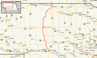
U.S. Route 275 (US 275) is a north–south United States highway. It is a branch of US 75, originally terminating at that route in Council Bluffs, Iowa. The highway's northern terminus is in O'Neill, Nebraska, at an intersection with U.S. Highway 20 and U.S. Highway 281. Its southern terminus is near Rock Port, Missouri, at an intersection with U.S. Highway 136.

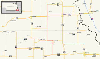
Nebraska Highway 31 is a highway in Nebraska. The southern terminus is near Louisville at an intersection with Nebraska Highway 50. The northern terminus is near Kennard at an intersection with U.S. Highway 30. The highway serves as a main north–south highway in the western portion of the Omaha Metro Area.

Nebraska Highway 133 is a highway in eastern Nebraska. Its southern terminus is at an intersection with U.S. Highway 6 in Omaha. Its northern terminus is at an intersection with U.S. Highway 30 in Blair.

Nebraska Highway 36 is a highway in Nebraska. Its western terminus is 0.17 miles (270 m) southwest of U.S. Highway 275 near Fremont, and its eastern terminus is at U.S. Highway 75 in Omaha.
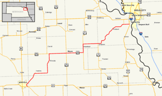
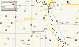
Nebraska Highway 35 is a highway in the northeastern part of the U.S. state of Nebraska. It has a western terminus in Norfolk at U.S. Highway 275 and Nebraska Highway 24 and an eastern terminus at U.S. Highway 77 and U.S. Highway 75 at Dakota City. The highway serves as a connector between Norfolk and Sioux City, Iowa.

Nebraska Highway 85 is a highway in Nebraska. It is a highway in the Omaha Metro Area. It has a southern terminus at Nebraska Highway 370 in Papillion. Its northern terminus is at U.S. Highway 275 and Nebraska Highway 92 on the border of Omaha and Ralston. It is a four-lane highway for its entire length. Most people in the Omaha area think of the highway as part of 84th Street.

Nebraska Highway 64 is a highway in Nebraska. There are two segments to the highway. The western segment lies in Butler County between U.S. Highway 81 and Nebraska Highway 15. The eastern segment goes through Saunders and Douglas counties between U.S. Highway 77 and U.S. Highway 75.

Nebraska Highway 27 is a highway in Nebraska. It is divided into three segments. The southernmost segment begins at the Kansas border and goes north to Haigler. The middle segment begins at Interstate 80 near Chappell and goes north to Oshkosh. The northernmost segment begins at Ellsworth and goes north to the South Dakota border.

Nebraska Highway 32 is a United States highway in Nebraska. It runs for 101 miles (163 km) through east central and eastern Nebraska. Its western terminus is at Nebraska Highway 14 in Petersburg. Its eastern terminus is at U.S. Highway 75 in Tekamah.

Nebraska Highway 69 is a highway in southeastern Nebraska. Its southern terminus is at an intersection with U.S. Highway 34 east of Waco. Its northern terminus is at an intersection with U.S. Highway 81 and Nebraska Highway 92 in Shelby.

Nebraska Highway 110 is a highway in northeastern Nebraska. Its southern terminus is at Nebraska Highway 35 west of Dakota City, and its northern terminus is at U.S. Highway 20 west of South Sioux City.
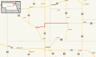
Nebraska Highway 112 is a highway in southeastern Nebraska. Its western terminus is at the Kansas border where it continues as K-148 southwest of Odell. Its eastern terminus is at U.S. Highway 77 west of Blue Springs.
Nebraska Highway 94 is a highway in northeastern Nebraska. It has a western terminus at an intersection with Nebraska Highway 9 and Nebraska Highway 16 in Pender. Its eastern terminus is at U.S. Highway 75 to the northwest of Macy.

Nebraska Highway 95 is a highway in northeastern Nebraska. It has a western terminus at an intersection with Nebraska Highway 11 west of Chambers. Its eastern terminus is at U.S. Highway 281 to the east of Chambers.
Nebraska Highway 97 is a highway in western Nebraska. It has a southern terminus north of North Platte at an intersection with U.S. Highway 83. The northern terminus is at U.S. Highway 20 in Valentine.
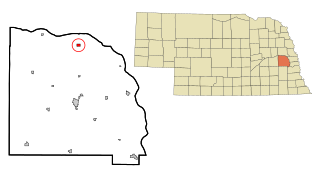
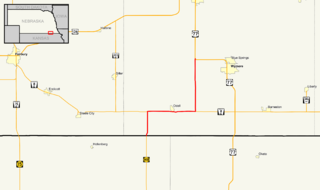
Nebraska Highway 98 is a highway in the northeastern part of the U.S. state of Nebraska. Its western terminus is at an intersection with Nebraska Highway 13 in Pierce. Its eastern terminus is at an intersection with Nebraska Highway 35 west of Wayne.
Nebraska Highway 89 is a highway in southern Nebraska. Its western terminus is at U.S. Highway 83 west of Danbury. Its eastern terminus is at an intersection with U.S. Highway 183 south of Alma.

Nebraska Highway 137 is a highway in northern Nebraska. Its southern terminus is at U.S. Highway 20 in Newport. Its northern terminus is at the South Dakota border where it continues as South Dakota Highway 47.
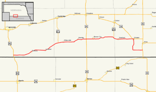
Nebraska Highway 105 is a highway in southeastern Nebraska. Its southern terminus is at an intersection with Nebraska Highway 8 south of Humboldt. Its northern terminus is at an intersection with Nebraska Highway 67 west of Brock.

Nebraska Highway 91 is a highway in central and eastern Nebraska. Its western terminus is at an intersection with Nebraska Highway 2 north of Dunning. Its eastern terminus is at an intersection with U.S. Highway 30 and U.S. Highway 75 in Blair.