Firth, Nebraska

Last updated

Firth, Nebraska
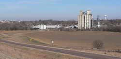
Firth, Nebraska from SW 1.JPG
Firth, seen from the southwest.
Lancaster County Nebraska Incorporated and Unincorporated areas Firth Highlighted.svg
Location of Firth, Nebraska
Coordinates: 40°32′10″N96°36′16″W / 40.53611°N 96.60444°W / 40.53611; -96.60444
Country United States
State Nebraska
County Lancaster
Township South Pass
Area
[1]
  Total0.35 sq mi (0.92 km2)
  Land0.35 sq mi (0.92 km2)
  Water0.00 sq mi (0.00 km2)
Elevation
[2]
1,355 ft (413 m)
Population
 (2020)
  Total649
  Density1,838.53/sq mi (708.98/km2)
Time zone UTC-6 (Central (CST))
  Summer (DST) UTC-5 (CDT)
ZIP code
68358
Area code 402
FIPS code 31-16935 [3]
GNIS feature ID2398879 [2]
Website http://www.firth.nebraska.gov

Firth is a village in Lancaster County, Nebraska, United States. It is part of the Lincoln, Nebraska Metropolitan Statistical Area. The population was 649 at the 2020 census.

Contents

Geography

According to the United States Census Bureau, the village has a total area of 0.28 square miles (0.73 km2), all land. [4] Located in South Pass Township, which is now used as a county precinct, Firth is the southernmost community in Lancaster County. [5] Firth is bordered to the east by Big Nemaha Reservoir.

Demographics

Historical population
CensusPop.Note
1880 230
1890 25912.6%
1900 30718.5%
1910 34311.7%
1920 332−3.2%
1930 322−3.0%
1940 3230.3%
1950 245−24.1%
1960 27713.1%
1970 32818.4%
1980 38417.1%
1990 47122.7%
2000 56419.7%
2010 5904.6%
2020 64910.0%
U.S. Decennial Census [6]

2010 census

As of the census [7] of 2010, there were 590 people, 204 households, and 147 families living in the village. The population density was 2,107.1 inhabitants per square mile (813.6/km2). There were 218 housing units at an average density of 778.6 units per square mile (300.6 units/km2). The racial makeup of the village was 89.8% White, 0.2% African American, 1.2% Native American, 0.7% Asian, 6.8% from other races, and 1.4% from two or more races. Hispanic or Latino of any race were 9.0% of the population.

There were 204 households, of which 45.6% had children under the age of 18 living with them, 58.8% were married couples living together, 9.3% had a female householder with no husband present, 3.9% had a male householder with no wife present, and 27.9% were non-families. 23.5% of all households were made up of individuals, and 13.3% had someone living alone who was 65 years of age or older. The average household size was 2.73 and the average family size was 3.31.

The median age in the village was 34.2 years. 32.2% of residents were under the age of 18; 4.9% were between the ages of 18 and 24; 28.9% were from 25 to 44; 15.6% were from 45 to 64; and 18.3% were 65 years of age or older. The gender makeup of the village was 51.4% male and 48.6% female.

2000 census

As of the census [3] of 2000, there were 564 people, 192 households, and 139 families living in the village. The population density was 1,852.5 inhabitants per square mile (715.3/km2). There were 200 housing units at an average density of 656.9 units per square mile (253.6 units/km2). The racial makeup of the village was 98.76% White, 0.18% African American, 0.35% Native American, 0.18% Asian, 0.18% from other races, and 0.35% from two or more races. Hispanic or Latino of any race were 0.18% of the population.

There were 192 households, out of which 41.1% had children under the age of 18 living with them, 64.6% were married couples living together, 6.3% had a female householder with no husband present, and 27.1% were non-families. 22.9% of all households were made up of individuals, and 13.0% had someone living alone who was 65 years of age or older. The average household size was 2.67 and the average family size was 3.15.

In the village, the population was spread out, with 26.8% under the age of 18, 7.3% from 18 to 24, 30.3% from 25 to 44, 11.2% from 45 to 64, and 24.5% who were 65 years of age or older. The median age was 35 years. For every 100 females, there were 91.2 males. For every 100 females age 18 and over, there were 91.2 males.

As of 2000 the median income for a household in the village was $41,944, and the median income for a family was $52,083. Males had a median income of $34,375 versus $24,875 for females. The per capita income for the village was $20,471. About 5.6% of families and 6.4% of the population were below the poverty line, including 10.7% of those under age 18 and 13.8% of those age 65 or over.
Schools

Norris School District 160 is located approximately two miles north and one mile west of Firth. Norris is made up of an elementary school, intermediate school, middle school, and a high school, all of which are in separate buildings but on the same campus. Norris provides Pre-K-12 education for students from Hickman, Holland, Firth, Cortland, Roca, Princeton, Panama, and parts of southern Lincoln. Norris School was named after a United States senator from Nebraska, George William Norris.

History

A courthouse square was planned in the area that would become Firth sometime before 1860. [8] However, due to Firth's remote location, residents would have had to travel to Nebraska City for supplies, meaning that the area remained largely uninhabited by non-Natives for many years. [8] Firth was settled in the early 1870s, as the Atchison & Nebraska Railroad was extended toward Lincoln. The post office was established in 1872, named for Superintendent Frank Firth of the Atchison & Nebraska Railroad, and was incorporated in 1879. [9] [10]

Once the railroad was completed, Firth became an important hub of business on the Atchison & Nebraska line, shipping 700 carloads of grain and livestock daily. [8] In 1916, a brick school was built to replace the two-story schoolhouse which had previously served the village. [8] In 1964, Firth became one of several schools to consolidate and form the Norris School District. [8] The brick school building was torn down in 1971 after years of vacancy. [8] Fundraising in the area allowed for the Lakeview Rest Home to be built in the 1970s on land donated by Henry and Bertha TeKolste. [8]

Notable person

Orah Dee Clark, the first superintendent of Alaska schools, was born in Firth. [11]

Related Research Articles

<span class="mw-page-title-main">Lancaster County, Nebraska</span> County in Nebraska, United States

Lancaster County is a county located in the U.S. state of Nebraska. As of the 2020 United States Census, the population was 322,608, making it the second-most populous county in Nebraska. Its county seat is Lincoln, the state capital. The county was created in 1859.

<span class="mw-page-title-main">Otoe County, Nebraska</span> County in Nebraska, United States

Otoe County is a county in the U.S. state of Nebraska. As of the 2020 United States Census, the population was 15,912. Its county seat is Nebraska City. The county was formed in 1854 and was named in reference to the Otoe Indian tribe.

<span class="mw-page-title-main">Lancaster, Kansas</span> City in Kansas, United States

Lancaster is a city in Atchison County, Kansas, United States. As of the 2020 census, the population of the city was 246.

<span class="mw-page-title-main">Alvo, Nebraska</span> Village in Nebraska, United States

Alvo is a village in Cass County, Nebraska, United States. The population was 115 at the 2020 census.

<span class="mw-page-title-main">Eagle, Nebraska</span> Village in Nebraska, United States

Eagle is a village in southwest Cass County, Nebraska, United States. As of the 2020 census, the village population was 1,065.

<span class="mw-page-title-main">Elmwood, Nebraska</span> Village in Nebraska, United States

Elmwood is a village in southeast Cass County, Nebraska, United States. The population was 654 at the 2020 census.

<span class="mw-page-title-main">Coleridge, Nebraska</span> Village in Nebraska, United States

Coleridge is a village in Cedar County, Nebraska, United States. The population was 537 at the 2020 census.

<span class="mw-page-title-main">Wood Lake, Nebraska</span> Village in Nebraska, United States

Wood Lake is a village in Cherry County, Nebraska, United States. The population was 63 at the 2010 census.

<span class="mw-page-title-main">Cortland, Nebraska</span> Village in Nebraska, United States

Cortland is a village in Gage County, Nebraska, United States. The population was 504 at the 2020 census.

<span class="mw-page-title-main">Spalding, Nebraska</span> Village in Greeley County, Nebraska, United States

Spalding is a village in Greeley County, Nebraska, United States. The population was 408 at the 2020 census.

<span class="mw-page-title-main">Bennet, Nebraska</span> City in Lancaster County, Nebraska, United States

Bennet is a city in Lancaster County, Nebraska, United States. It is part of the Lincoln, Nebraska Metropolitan Statistical Area. The population was 1,082 at the 2020 census.

<span class="mw-page-title-main">Denton, Nebraska</span> Village in Nebraska, United States

Denton is a village in Lancaster County, Nebraska, United States. It is part of the Lincoln, Nebraska Metropolitan Statistical Area. The population was 189 at the 2020 census.

<span class="mw-page-title-main">Hallam, Nebraska</span> Village in Nebraska, United States

Hallam is a village in Lancaster County, Nebraska, United States. It is part of the Lincoln, Nebraska Metropolitan Statistical Area. The population was 268 at the 2020 census.

<span class="mw-page-title-main">Hickman, Nebraska</span> City in Nebraska, United States

Hickman is a city in Lancaster County, Nebraska, United States. It is part of the Lincoln, Nebraska Metropolitan Statistical Area. The population was 2,607 at the 2020 census.

<span class="mw-page-title-main">Malcolm, Nebraska</span> Village in Nebraska, United States

Malcolm is a village in Lancaster County, Nebraska, United States. It is part of the Lincoln, Nebraska Metropolitan Statistical Area. The population was 457 at the 2020 census.

<span class="mw-page-title-main">Panama, Nebraska</span> Village in Nebraska, United States

Panama is a village in Lancaster County, Nebraska, United States. It is part of the Lincoln, Nebraska Metropolitan Statistical Area. The population was 235 at the 2020 census.

<span class="mw-page-title-main">Raymond, Nebraska</span> Village in Nebraska, United States

Raymond is a village in Lancaster County, Nebraska, United States. It is part of the Lincoln, Nebraska Metropolitan Statistical Area. The population was 159 at the 2020 census.

<span class="mw-page-title-main">Roca, Nebraska</span> Village in Nebraska, United States

Roca is a village in Lancaster County, Nebraska, United States. It is part of the Lincoln, Nebraska Metropolitan Statistical Area. The population was 201 at the 2020 census.

<span class="mw-page-title-main">Waverly, Nebraska</span> Village in Nebraska, United States

Waverly is a village in Lancaster County, Nebraska, United States. It is part of the Lincoln, Nebraska Metropolitan Statistical Area. The population was 4,279 at the 2020 census.

<span class="mw-page-title-main">Dawson, Nebraska</span> Village in Richardson County, Nebraska, United States

Dawson is a village in Richardson County, Nebraska, United States. The population was 148 at the 2020 census.

References

  1. "ArcGIS REST Services Directory". United States Census Bureau. Retrieved September 18, 2022.
  2. 1 2 U.S. Geological Survey Geographic Names Information System: Firth, Nebraska
  3. 1 2 "U.S. Census website". United States Census Bureau . Retrieved January 31, 2008.
  4. "US Gazetteer files 2010". United States Census Bureau. Archived from the original on January 12, 2012. Retrieved June 24, 2012.
  5. History of Lancaster Co and Townships. Lincoln-Lancaster Genealogical Society. Accessed 3 August 2024.
  6. "Census of Population and Housing". Census.gov. Retrieved June 4, 2015.
  7. "U.S. Census website". United States Census Bureau . Retrieved June 24, 2012.
  8. 1 2 3 4 5 6 7 "Village of Firth : About Firth : History". www.firth.nebraska.gov. Retrieved March 25, 2018.
  9. "Lancaster County, Part 29: Firth." Andreas's History of the State of Nebraska. Retrieved November 29, 2012.
  10. "Firth--Lancaster County". Nebraska... Our Towns. Archived November 23, 2011, at the Wayback Machine Retrieved November 29, 2012.
  11. "Photographs, 1962, Photographs of Orah Dee Clark on Orah Dee Clark Day" (PDF). Collection. Anchorage Museum. Archived from the original (PDF) on October 29, 2013. Retrieved October 28, 2013.