Newman Grove, Nebraska

Last updated

Newman Grove, Nebraska
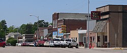
Newman Grove, Nebraska downtown.JPG
Downtown Newman Grove: north side of Hale Avenue, May 2010
Madison County Nebraska Incorporated and Unincorporated areas Newman Grove Highlighted.svg
Location in Madison County and the state of Nebraska
Coordinates: 41°44′49″N97°46′36″W / 41.74694°N 97.77667°W / 41.74694; -97.77667
Country United States
State Nebraska
Counties Madison, Platte
Area
[1]
  Total0.55 sq mi (1.41 km2)
  Land0.55 sq mi (1.41 km2)
  Water0.00 sq mi (0.00 km2)
Elevation
[2]
1,745 ft (532 m)
Population
 (2020) [3]
  Total667
  Density1,223.85/sq mi (472.45/km2)
Time zone UTC-6 (Central (CST))
  Summer (DST) UTC-5 (CDT)
ZIP code
68758
Area code 402
FIPS code 31-34230 [4]
GNIS feature ID838343 [2]
Website cityofnewmangrove.com

Newman Grove is a city in Madison and Platte counties in Nebraska, United States. The population was 667 at the 2020 census. [3]

Contents

The Madison County portion of Newman Grove is part of the Norfolk Micropolitan Statistical Area.

History

Newman Grove was platted in 1887 when the Fremont, Elkhorn and Missouri Valley Railroad was extended to that point. [5] It was named for a grove of trees nearby planted by Newman Warren. [6] [5]

Geography

Newman Grove is in southwestern Madison County, with a small portion extending south into Platte County. Nebraska Highway 45 passes through the city as 8th Street; the highway leads north 23 miles (37 km) to Tilden and south 3 miles (5 km) to its terminus at Nebraska Highway 91. Madison, the Madison county seat, is 22 miles (35 km) to the northeast via Highways 45 and 32.

According to the U.S. Census Bureau, Newman Grove has a total area of 0.55 square miles (1.42 km2), all land. [1] Shell Creek runs along the northern edge of the city, flowing southeast to join the Platte River east of Schuyler.

Demographics

Historical population
CensusPop.Note
1890 330
1900 696110.9%
1910 85022.1%
1920 1,26048.2%
1930 1,146−9.0%
1940 1,036−9.6%
1950 1,004−3.1%
1960 880−12.4%
1970 863−1.9%
1980 9307.8%
1990 787−15.4%
2000 7971.3%
2010 721−9.5%
2020 667−7.5%
U.S. Decennial Census [7]

2010 census

As of the census [8] of 2010, there were 721 people, 320 households, and 183 families residing in the city. The population density was 1,310.9 inhabitants per square mile (506.1/km2). There were 382 housing units at an average density of 694.5 per square mile (268.1/km2). The racial makeup of the city was 91.1% White, 0.3% Native American, 0.7% Asian, 7.1% from other races, and 0.8% from two or more races. Hispanic or Latino of any race were 10.1% of the population.

There were 320 households, of which 25.3% had children under the age of 18 living with them, 46.6% were married couples living together, 7.8% had a female householder with no husband present, 2.8% had a male householder with no wife present, and 42.8% were non-families. 38.8% of all households were made up of individuals, and 22.8% had someone living alone who was 65 years of age or older. The average household size was 2.15 and the average family size was 2.86.

The median age in the city was 50.1 years. 21.8% of residents were under the age of 18; 3.6% were between the ages of 18 and 24; 16.7% were from 25 to 44; 32.8% were from 45 to 64; and 25.2% were 65 years of age or older. The gender makeup of the city was 46.6% male and 53.4% female.

2000 census

As of the census [4] of 2000, there were 797 people, 323 households, and 190 families residing in the city. The population density was 1,567.9 people per square mile (605.4 people/km2). There were 372 housing units at an average density of 731.8 per square mile (282.5/km2). The racial makeup of the city was 90.72% White, 0.25% Native American, 1.00% Asian, 7.53% from other races, and 0.50% from two or more races. Hispanic or Latino of any race were 13.17% of the population.

There were 323 households, out of which 27.9% had children under the age of 18 living with them, 52.3% were married couples living together, 4.0% had a female householder with no husband present, and 40.9% were non-families. 38.4% of all households were made up of individuals, and 24.5% had someone living alone who was 65 years of age or older. The average household size was 2.29 and the average family size was 3.10.

In the city, the population was spread out, with 24.8% under the age of 18, 4.8% from 18 to 24, 22.0% from 25 to 44, 20.6% from 45 to 64, and 27.9% who were 65 years of age or older. The median age was 43 years. For every 100 females, there were 89.8 males. For every 100 females age 18 and over, there were 80.4 males.

As of 2000 the median income for a household in the city was $30,329, and the median income for a family was $39,653. Males had a median income of $26,786 versus $20,000 for females. The per capita income for the city was $16,247. About 3.5% of families and 11.9% of the population were below the poverty line, including 18.5% of those under age 18 and 11.4% of those age 65 or over.
Education

Newman Grove Public Schools is a K-12 public school district that serves the area. [9]

Religion

There are five churches in town: Newman Grove United Methodist Church, Trinity Lutheran Church, Zion Shell Creek Salem Church, Zion Evangelical Lutheran Church, and Fellowship Bible Church. [10]

See also

Related Research Articles

<span class="mw-page-title-main">Platte County, Nebraska</span> County in Nebraska, United States

Platte County is a county located in the U.S. state of Nebraska. As of the 2020 United States Census, the population was 34,296. Its county seat is Columbus. The county was created in 1855.

<span class="mw-page-title-main">Madison County, Nebraska</span> County in Nebraska, United States

Madison County is a county in the U.S. state of Nebraska. As of the 2020 United States Census, the population was 35,585. Its county seat is Madison and its largest city is Norfolk. Madison County was likely named for Madison, Wisconsin, which is where many of the county’s residents came from; the city was named for James Madison, fourth President of the United States.

<span class="mw-page-title-main">Dodge County, Nebraska</span> County in Nebraska, United States

Dodge County is a county in the U.S. state of Nebraska. As of the 2020 United States Census, the population was 37,167. Its county seat is Fremont. The county was formed in 1855 and named after Iowa Senator Augustus C. Dodge.

<span class="mw-page-title-main">Smithville, Missouri</span> City in Missouri, United States

Smithville is a city in Clay and Platte counties in the U.S. state of Missouri and is part of the Kansas City metropolitan area, along the Little Platte River. The population was 10,406 at the 2020 United States Census.

<span class="mw-page-title-main">Edgerton, Missouri</span> City in Missouri, United States

Edgerton is a city in northeastern Platte County, Missouri and is part of the Kansas City metropolitan area within the United States. The population was 601 at the 2020 census.

<span class="mw-page-title-main">Platte City, Missouri</span> City in Missouri, United States

Platte City is a city in and the county seat of Platte County, Missouri within the United States. The population was 4,784 at the 2020 census. The city is part of the Kansas City metropolitan area.

<span class="mw-page-title-main">South Bend, Nebraska</span> Village in Nebraska, United States

South Bend is a village in Cass County, Nebraska, United States. The population was 92 at the 2020 census. The main landmark is a pedestrian bridge across the Platte River which leads to Schramm Park State Recreation Area. It was built in 2004 on the pillars of the abandoned Rock Island Railroad bridge. Thirty-five trains a day—most of them coal trains—still pass through the area on the BNSF Railway main.

<span class="mw-page-title-main">North Bend, Nebraska</span> City in Nebraska, United States

North Bend is a city in Dodge County, Nebraska, United States. The population was 1,177 at the 2010 census.

<span class="mw-page-title-main">Meadow Grove, Nebraska</span> Village in Nebraska, United States

Meadow Grove is a village in Madison County, Nebraska, United States. It is part of the Norfolk, Nebraska Micropolitan Statistical Area. The population was 301 at the 2010 census.

<span class="mw-page-title-main">Bayard, Nebraska</span> City in Nebraska, United States

Bayard is a city in Morrill County, Nebraska, United States. The population was 1,209 at the 2010 census.

<span class="mw-page-title-main">Holdrege, Nebraska</span> City in Nebraska, United States

Holdrege is a city in Phelps County, Nebraska, United States. The population was 5,495 at the 2010 census. It is the county seat of Phelps County. The Nebraska Prairie Museum is located in Holdrege.

<span class="mw-page-title-main">Cornlea, Nebraska</span> Village in Platte County, Nebraska, United States

Cornlea is a village in Platte County, Nebraska, United States. The population was 36 at the 2010 census.

<span class="mw-page-title-main">Creston, Nebraska</span> Village in Platte County, Nebraska, United States

Creston is a village in Platte County, Nebraska, United States. The population was 203 at the 2010 census.

<span class="mw-page-title-main">Humphrey, Nebraska</span> City in Platte County, Nebraska, United States

Humphrey is a city in Platte County, Nebraska, United States. The population was 760 at the 2010 census.

<span class="mw-page-title-main">Monroe, Nebraska</span> Village in Platte County, Nebraska, United States

Monroe is a village in Platte County, Nebraska, United States. The population was 284 at the 2010 census.

<span class="mw-page-title-main">Platte Center, Nebraska</span> Village in Platte County, Nebraska, United States

Platte Center is a village in Platte County, Nebraska, United States. The population was 336 at the 2010 census.

<span class="mw-page-title-main">Tarnov, Nebraska</span> Village in Platte County, Nebraska, United States

Tarnov is a village in Platte County, Nebraska, United States. The population was 46 at the 2010 census.

<span class="mw-page-title-main">Gering, Nebraska</span> City in and county seat of Scotts Bluff County, Nebraska, United States

Gering is a city in and the county seat of Scotts Bluff County, Nebraska, United States, in the Panhandle region of the state. The population was 8,564 at the 2020 census, making it the 17th most populous city in Nebraska.

<span class="mw-page-title-main">Platte Woods, Missouri</span> City in Missouri, United States

Platte Woods is a city in Platte County, Missouri and is part of the Kansas City metropolitan area within the United States. The population was 394 as of the 2020 census.

<span class="mw-page-title-main">Tilden, Nebraska</span> City in Antelope and Madison counties in Nebraska, United States

Tilden is a city in Antelope and Madison counties in Nebraska, United States. The population was 953 at the 2010 census. The Madison County portion of Tilden is part of the Norfolk, Nebraska Micropolitan Statistical Area.

References

  1. 1 2 "2023 U.S. Gazetteer Files: Nebraska". United States Census Bureau. Retrieved June 14, 2024.
  2. 1 2 U.S. Geological Survey Geographic Names Information System: Newman Grove, Nebraska
  3. 1 2 "P1. Race – Newman Grove city, Nebraska: 2020 DEC Redistricting Data (PL 94-171)". U.S. Census Bureau. Retrieved June 13, 2024.
  4. 1 2 "U.S. Census website". United States Census Bureau . Retrieved January 31, 2008.
  5. 1 2 "Newman Grove, Madison County". Center for Advanced Land Management Information Technologies. University of Nebraska. Retrieved August 19, 2014.
  6. Fitzpatrick, Lillian L. (1960). Nebraska Place-Names. University of Nebraska Press. p. 101. ISBN   0-8032-5060-6. A 1925 edition is available for download at University of Nebraska—Lincoln Digital Commons.
  7. "Census of Population and Housing". Census.gov. Retrieved June 4, 2015.
  8. "U.S. Census website". United States Census Bureau . Retrieved June 24, 2012.
  9. "Newman Grove". www.newman.esu8.org.
  10. "Worship". City of Newman Grove - Nebraska Public Power District. Retrieved June 14, 2024.