Giltner, Nebraska

Last updated

Giltner, Nebraska
Giltner, Nebraska Commercial from Railroad 1.JPG
Downtown Giltner: Commercial Avenue
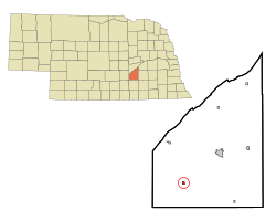
Hamilton County Nebraska Incorporated and Unincorporated areas Giltner Highlighted.svg
Location of Giltner, Nebraska
Coordinates: 40°46′30″N98°09′13″W / 40.77500°N 98.15361°W / 40.77500; -98.15361
Country United States
State Nebraska
County Hamilton
Area
[1]
  Total0.39 sq mi (1.01 km2)
  Land0.39 sq mi (1.00 km2)
  Water0.00 sq mi (0.01 km2)
Elevation
[2]
1,831 ft (558 m)
Population
 (2020)
  Total406
  Density1,049.10/sq mi (404.71/km2)
Time zone UTC-6 (Central (CST))
  Summer (DST) UTC-5 (CDT)
ZIP code
68841
Area code 402
FIPS code 31-18825 [3]
GNIS feature ID2398964 [2]

Giltner is a village in Hamilton County, Nebraska, United States. The population was 352 at the 2010 census.

Contents

Geography

According to the United States Census Bureau, the village has a total area of 0.39 square miles (1.01 km2), all land. [4]

Naming history

In 1886, the Lincoln Land Company purchased land in the Union township. The Lincoln Land Company's business was to purchase land along the railroad and develop towns along the line. In May, a town was platted and named "Huntington", after an employee's home town in Pennsylvania. [5]

In February 1887, the post office asked that the town's name be changed, due to the original name's similarity to Hartington, Nebraska. The town was accordingly given the name "Bromfield". By 1890, there was a local newspaper called the Bromfield Bulletin, as well as a number of stores and services, a lumberyard, two grain elevators, a school, a saloon and a church. At this time, the population of Bromfield was just under 200 people. [5]

The town was renamed again in 1895, again at the request of the post office, and again because of its similarity to that of another town: Bloomfield, Nebraska. The new name was chosen to honor H. M. Giltner, the minister who had established the town's Presbyterian church. [5]

Baseball

Giltner was home to minor league baseball. In 1903, the Giltner team played as charter members of the short–lived Central Nebraska League, an Independent level five-team league. The Central Nebraska League folded after the 1903 season. [6] [7]

Demographics

Historical population
CensusPop.Note
1890 195
1900 28244.6%
1910 41045.4%
1920 387−5.6%
1930 355−8.3%
1940 325−8.5%
1950 284−12.6%
1960 2933.2%
1970 40839.2%
1980 400−2.0%
1990 367−8.2%
2000 3896.0%
2010 352−9.5%
2020 40615.3%
U.S. Decennial Census [8]

2010 census

As of the census [9] of 2010, there were 352 people, 134 households, and 102 families residing in the village. The population density was 902.6 inhabitants per square mile (348.5/km2). There were 151 housing units at an average density of 387.2 per square mile (149.5/km2). The racial makeup of the village was 98.6% White, 0.3% Pacific Islander, 0.3% from other races, and 0.9% from two or more races. Hispanic or Latino people of any race were 0.3% of the population.

There were 134 households, of which 37.3% had children under the age of 18 living with them, 66.4% were married couples living together, 4.5% had a female householder with no husband present, 5.2% had a male householder with no wife present, and 23.9% were non-families. 18.7% of all households were made up of individuals, and 8.9% had someone living alone who was 65 years of age or older. The average household size was 2.63 and the average family size was 2.97.

The median age in the village was 40 years. 27.6% of residents were under the age of 18; 3.7% were between the ages of 18 and 24; 26.1% were from 25 to 44; 29% were from 45 to 64; and 13.6% were 65 years of age or older. The gender makeup of the village was 51.1% male and 48.9% female.

2000 census

As of the census [3] of 2000, there were 389 people, 139 households, and 104 families residing in the village. The population density was 1,283.6 inhabitants per square mile (495.6/km2). There were 153 housing units at an average density of 504.8 per square mile (194.9/km2). The racial makeup of the village was 97.94% White, 0.51% African American, 0.26% Native American, 0.77% from other races, and 0.51% from two or more races. Hispanic or Latino people of any race were 1.03% of the population.

There were 139 households, out of which 36.0% had children under the age of 18 living with them, 61.9% were married couples living together, 7.9% had a female householder with no husband present, and 24.5% were non-families. 22.3% of all households were made up of individuals, and 9.4% had someone living alone who was 65 years of age or older. The average household size was 2.80 and the average family size was 3.29.

In the village, the population was spread out, with 30.8% under the age of 18, 7.5% from 18 to 24, 28.8% from 25 to 44, 21.9% from 45 to 64, and 11.1% who were 65 years of age or older. The median age was 34 years. For every 100 females, there were 95.5 males. For every 100 females age 18 and over, there were 102.3 males.

As of 2000 the median income for a household in the village was $40,417, and the median income for a family was $45,179. Males had a median income of $27,583 versus $22,143 for females. The per capita income for the village was $13,937. About 11.0% of families and 10.6% of the population were below the poverty line, including 16.1% of those under age 18 and 9.1% of those age 65 or over.

Related Research Articles

<span class="mw-page-title-main">Cedar Creek, Nebraska</span> Village in Nebraska, United States

Cedar Creek is a village in Cass County, Nebraska, United States. The population was 465 at the 2020 census.

<span class="mw-page-title-main">Greenwood, Nebraska</span> Village in Nebraska, United States

Greenwood is a village in northwest Cass County, Nebraska, United States. The population was 595 at the 2020 census.

<span class="mw-page-title-main">Uehling, Nebraska</span> Village in Nebraska, United States

Uehling is a village in Dodge County, Nebraska, United States. The population was 230 at the 2010 census.

<span class="mw-page-title-main">Boys Town, Nebraska</span> Village in Douglas County, Nebraska, United States

Boys Town is a village in Douglas County, Nebraska, United States. The population was 410 at the 2020 census. Boys Town is an enclave and a suburb of Omaha.

<span class="mw-page-title-main">Waterloo, Nebraska</span> Village in Douglas County, Nebraska, United States

Waterloo is a village in Douglas County, Nebraska, United States. The population was 935 at the 2020 census.

<span class="mw-page-title-main">Clatonia, Nebraska</span> Village in Nebraska, United States

Clatonia is a village in Gage County, Nebraska, United States. The population was 263 at the 2020 census.

<span class="mw-page-title-main">Wolbach, Nebraska</span> Village in Greeley County, Nebraska, United States

Wolbach is a village in Greeley county, Nebraska, United States. The population was 283 at the time of the 2010 census.

<span class="mw-page-title-main">Stamford, Nebraska</span> Village in Nebraska, United States

Stamford is a village in Harlan County, Nebraska, United States. The population was 183 at the 2010 census.

<span class="mw-page-title-main">Stuart, Nebraska</span> Village in Nebraska, United States

Stuart is a village in Holt County, Nebraska, United States. The population was 590 at the 2010 census.

<span class="mw-page-title-main">Center, Nebraska</span> Village in and county seat of Knox County, Nebraska, United States

Center is a village in, and county seat of, Knox County, Nebraska, United States. The population was 73 at the 2020 census.

<span class="mw-page-title-main">Stapleton, Nebraska</span> Village in and county seat of Logan County, Nebraska, United States

Stapleton is a village in and the county seat of Logan County, Nebraska, United States. The population was 267 at the 2020 census.

<span class="mw-page-title-main">Shubert, Nebraska</span> Village in Richardson County, Nebraska, United States

Shubert is a village in Richardson County, Nebraska, United States. The population was 163 at the 2020 census.

<span class="mw-page-title-main">Dorchester, Nebraska</span> Village in Nebraska, United States

Dorchester is a village in Saline County, Nebraska, United States. It is thirty-eight miles southwest from the Lincoln, Nebraska metropolitan area. The population was 596 at the 2020 census.

<span class="mw-page-title-main">Ceresco, Nebraska</span> Village in Saunders County, Nebraska, United States

Ceresco is a farming village in Saunders County, Nebraska, United States. The population was 919 at the 2020 census. It is located near U.S. Highway 77, just north of Lincoln, just south of Wahoo, and a short distance southwest of Omaha.

<span class="mw-page-title-main">Leshara, Nebraska</span> Village in Saunders County, Nebraska, United States

Leshara is a village in Saunders County, Nebraska, United States. The population was 108 at the 2020 census.

<span class="mw-page-title-main">Prague, Nebraska</span> Village in Saunders County, Nebraska, United States

Prague is a village in Saunders County, Nebraska, United States. The population was 291 at the 2020 census. It was named after Prague, capital of Bohemia.

<span class="mw-page-title-main">Clinton, Nebraska</span> Village in Sheridan County, Nebraska, United States

Clinton is a village in Sheridan County, Nebraska, United States. The village was named for Clinton, Iowa. The population was 41 at the 2010 census.

<span class="mw-page-title-main">Davenport, Nebraska</span> Village in Thayer County, Nebraska, United States

Davenport is a village in Thayer County, Nebraska, United States. The population was 321 at the 2020 census.

<span class="mw-page-title-main">Kennard, Nebraska</span> Village in Washington County, Nebraska, United States

Kennard is a village in Washington County, Nebraska, United States. The population was 361 at the 2010 census.

<span class="mw-page-title-main">Oxford, Nebraska</span> Village in Nebraska, United States

Oxford is a village in Furnas and Harlan counties in the U.S. state of Nebraska. The population was 779 at the 2010 census.

References

  1. "ArcGIS REST Services Directory". United States Census Bureau. Retrieved September 18, 2022.
  2. 1 2 U.S. Geological Survey Geographic Names Information System: Giltner, Nebraska
  3. 1 2 "U.S. Census website". United States Census Bureau . Retrieved January 31, 2008.
  4. "US Gazetteer files 2010". United States Census Bureau. Archived from the original on March 5, 2012. Retrieved June 24, 2012.
  5. 1 2 3 Sherard, Gerald E. "Giltner--Hamilton County". Archived March 11, 2014, at the Wayback Machine Nebraska... Our Towns. Archived November 23, 2011, at the Wayback Machine Retrieved March 10, 2014.
  6. "1903 Central Nebraska League". Baseball-Reference.com.
  7. "1903 Giltner Statistics". Baseball-Reference.com.
  8. "Census of Population and Housing". Census.gov. Retrieved June 4, 2015.
  9. "U.S. Census website". United States Census Bureau . Retrieved June 24, 2012.