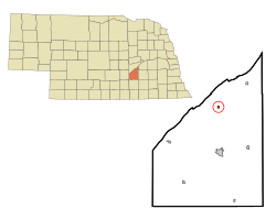
Marquette, Nebraska | |
---|---|
Coordinates: 41°00′23″N98°00′35″W / 41.00639°N 98.00972°W | |
Country | United States |
State | Nebraska |
County | Hamilton |
Area | |
• Total | 0.21 sq mi (0.54 km2) |
• Land | 0.21 sq mi (0.54 km2) |
• Water | 0.00 sq mi (0.00 km2) |
Elevation | 1,821 ft (555 m) |
Population (2020) | |
• Total | 236 |
• Density | 1,140.10/sq mi (440.10/km2) |
Time zone | UTC-6 (Central (CST)) |
• Summer (DST) | UTC-5 (CDT) |
ZIP code | 68854 |
Area code | 402 |
FIPS code | 31-30730 [3] |
GNIS feature ID | 2399261 [2] |
Marquette is a village in Hamilton County, Nebraska, United States. The population was 229 at the 2010 census.
Marquette was platted in 1882 when the Burlington and Missouri River Railroad was extended to that point. [4] It was named for Thomas M. Marquette, a railroad official. [5] Marquette was incorporated as a village in 1889. [6]
According to the United States Census Bureau, the village has a total area of 0.21 square miles (0.54 km2), all land. [7]
Census | Pop. | Note | %± |
---|---|---|---|
1890 | 261 | — | |
1900 | 210 | −19.5% | |
1910 | 290 | 38.1% | |
1920 | 305 | 5.2% | |
1930 | 318 | 4.3% | |
1940 | 245 | −23.0% | |
1950 | 218 | −11.0% | |
1960 | 210 | −3.7% | |
1970 | 239 | 13.8% | |
1980 | 303 | 26.8% | |
1990 | 211 | −30.4% | |
2000 | 282 | 33.6% | |
2010 | 229 | −18.8% | |
2020 | 236 | 3.1% | |
U.S. Decennial Census [8] |
As of the census [9] of 2010, there were 229 people, 89 households, and 68 families residing in the village. The population density was 1,090.5 inhabitants per square mile (421.0/km2). There were 104 housing units at an average density of 495.2 per square mile (191.2/km2). The racial makeup of the village was 99.6% White and 0.4% from two or more races. Hispanic or Latino of any race were 2.6% of the population.
There were 89 households, of which 36.0% had children under the age of 18 living with them, 55.1% were married couples living together, 11.2% had a female householder with no husband present, 10.1% had a male householder with no wife present, and 23.6% were non-families. 18.0% of all households were made up of individuals, and 3.3% had someone living alone who was 65 years of age or older. The average household size was 2.57 and the average family size was 2.93.
The median age in the village was 41.3 years. 28.4% of residents were under the age of 18; 6.1% were between the ages of 18 and 24; 20.1% were from 25 to 44; 32.3% were from 45 to 64; and 13.1% were 65 years of age or older. The gender makeup of the village was 51.5% male and 48.5% female.
As of the census [3] of 2000, there were 282 people, 106 households, and 83 families residing in the village. The population density was 1,368.5 inhabitants per square mile (528.4/km2). There were 115 housing units at an average density of 558.1 per square mile (215.5/km2). The racial makeup of the village was 98.94% White, 0.71% from other races, and 0.35% from two or more races. Hispanic or Latino of any race were 1.42% of the population.
There were 106 households, out of which 35.8% had children under the age of 18 living with them, 71.7% were married couples living together, 3.8% had a female householder with no husband present, and 20.8% were non-families. 18.9% of all households were made up of individuals, and 2.8% had someone living alone who was 65 years of age or older. The average household size was 2.66 and the average family size was 3.01.
In the village, the population was spread out, with 28.4% under the age of 18, 7.1% from 18 to 24, 28.4% from 25 to 44, 28.4% from 45 to 64, and 7.8% who were 65 years of age or older. The median age was 36 years. For every 100 females, there were 112.0 males. For every 100 females age 18 and over, there were 102.0 males.
As of 2000 the median income for a household in the village was $34,375, and the median income for a family was $36,786. Males had a median income of $26,250 versus $14,792 for females. The per capita income for the village was $16,272. None of the families and 3.5% of the population were living below the poverty line, including none of those under the age of 18 and 16.7% of those 65 and older.
Dwight is a village in Butler County, Nebraska, United States. The population was 204 at the 2010 census.
Manley is a village in Cass County, Nebraska, United States. The population was 167 at the 2020 census.
Murray is a village in Cass County, Nebraska, United States. The population was 480 at the 2020 census.
Belden is a village in Cedar County, Nebraska, United States. The population was 112 at the 2020 census.
Rogers is a village in Colfax County, Nebraska, United States. The population was 95 at the 2010 census.
Milligan is a village in Fillmore County, Nebraska, United States. The population was 241 at the 2020 census.
Chambers is a village in Holt County, Nebraska, United States. The population was 268 at the 2010 census.
Elba is a village in Howard County, Nebraska, United States. The population was 215 at the 2010 census. It is part of the Grand Island, Nebraska Micropolitan Statistical Area.
Sutherland is a village in Lincoln County, Nebraska, United States. It is part of the North Platte, Nebraska Micropolitan Statistical Area. The population was 1,286 at the 2010 census.
Clarks is a village in Merrick County, Nebraska, United States. The population was 344 at the 2020 census. It is part of the Grand Island, Nebraska Micropolitan Statistical Area.
Auburn is a city in Nemaha County, Nebraska, United States, and its county seat. The population was 3,470 at the 2020 census.
Nelson is a village and the county seat of Nuckolls County, Nebraska, United States. The population was 488 at the 2010 census. The city was named for C. Nelson Wheeler, the original owner of the town site.
Bellevue is a suburban city in Sarpy County, Nebraska, United States. It is part of the Omaha–Council Bluffs metropolitan area, and had a population of 64,176 as of the 2020 census, making it the 3rd most populous city in Nebraska, behind Omaha and Lincoln, and the second largest city in the U.S. named "Bellevue," behind Bellevue, Washington.
Colon is a village in Saunders County, Nebraska, United States. The population was 107 at the 2020 census. Amenities include a post office and bank branch. Colon is seven miles north of the county seat Wahoo.
Malmo is a village in Saunders County, Nebraska, United States. The population was 94 at the 2020 census.
Weston is a village in Saunders County, Nebraska, United States. The population was 250 at the 2020 census.
Seward is a city and county seat of Seward County, Nebraska, United States. The population was 6,964 at the 2010 census. Seward is part of the Lincoln, Nebraska Metropolitan Statistical Area.
Carleton is a village in Thayer County, Nebraska, United States. The population was 94 at the 2020 census.
Oxford is a village in Furnas and Harlan counties in the U.S. state of Nebraska. The population was 779 at the 2010 census.
Marquette is a village in Green Lake County, Wisconsin, United States. The population was 150 at the 2010 census. The village is located within the Town of Marquette. Marquette uses the postal code 53947.