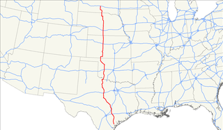
U.S. Route 183 (US 183) is a north–south United States highway. The highway's northern terminus is in Presho, South Dakota, at an intersection with Interstate 90. Its southern terminus is in Refugio, Texas, at the southern intersection of U.S. Highway 77 and Alternate US 77.

Nebraska Highway 31 is a highway in Nebraska. The southern terminus is near Louisville at an intersection with Nebraska Highway 50. The northern terminus is near Kennard at an intersection with U.S. Highway 30. The highway serves as a main north–south highway in the western portion of the Omaha Metro Area.

Nebraska Highway 2 is a state highway in Nebraska consisting of two discontinuous segments. The western segment begins at the South Dakota border northwest of Crawford and ends southeast of Grand Island at an intersection with Interstate 80. The eastern segment begins in Lincoln and ends at the Iowa border at Nebraska City. Previously, the two segments were connected via a route shared with U.S. Highway 34 between Grand Island and Lincoln.

Nebraska Highway 4 is a highway in Nebraska. The entirety of the route is in Nebraska's southern tier of counties. Beatrice is the only city with over 1,000 in population on the highway. Its western terminus is at an intersection with US 6 and US 34 southwest of Atlanta. Its eastern terminus is at an intersection with US 75 north of Dawson.

Nebraska Highway 67 is a highway in southeastern Nebraska. Its southern terminus is at an intersection with U.S. Highway 73 near Verdon. Its northern terminus is at an intersection with U.S. Highway 34 near Nehawka. The segment between Nebraska Highway 2 and US 34 is one of four segments of road in the Nebraska highway system which is gravel.

Nebraska Highway 8 (N-8) is a highway in southern and southeastern Nebraska. Its western terminus is at Nebraska Highway 14 in Superior and its eastern terminus is at U.S. Highway 73 (US 73) in Falls City. It runs through the southern tier of counties in Nebraska and is always within 10 miles (16 km) of the Kansas border.

Nebraska Highway 11 (N‑11) is a state highway in central and northern Nebraska, United States. Its southern terminus is at Interstate 80 (I‑80) south of Wood River. Its northern terminus is at the South Dakota border north of Butte. The highway goes through the eastern portion of the Sand Hills.

Nebraska Highway 12 is a highway in northern and northeastern Nebraska. It has a western terminus at U.S. Highway 83 in Valentine and an eastern terminus at U.S. Highway 20 west of Jackson. The highway largely lies within 10 miles (16 km) of the South Dakota border its entire length. The highway has been designated the Outlaw Trail Scenic Byway.

Nebraska Highway 14 (N-14) is a highway in the U.S. state of Nebraska. It has a southern terminus at the Kansas border, where it continues south as K-14, southwest of Superior and a northern terminus east of Niobrara at the South Dakota border.

Nebraska Highway 15 (N-15) is a highway in eastern Nebraska, United States. It has a southern terminus at the Kansas border south of Fairbury and a northern terminus northeast of Maskell at the South Dakota border.

Nebraska Highway 64 is a highway in Nebraska. There are two segments to the highway. The western segment lies in Butler County between U.S. Highway 81 and Nebraska Highway 15. The eastern segment goes through Saunders and Douglas counties between U.S. Highway 77 and U.S. Highway 75.
U.S. Highway 20 is a part of the United States Numbered Highway System that runs for 3,365 miles (5,415 km) from Newport, Oregon to Boston, Massachusetts. Within the State of Nebraska it is a state highway that begins on the Wyoming–Nebraska state line west of Harrison near the Niobrara River and runs to the Nebraska–Iowa state line in South Sioux City. Throughout its 431.60-mile (694.59 km) length the route passes through a diverse range of landscapes including bluffs and escarpments in the Northwest Panhandle, the Nebraska Sandhills in the northern part of the state, and rolling hills and plains as the highway approaches the Missouri River valley south of Sioux City, Iowa. Throughout its length, US 20 is a two-lane highway with the exception of the easternmost 8.45 miles (13.60 km) which is four-lane divided highway, the last 3.21 miles (5.17 km) of which is concurrent with Interstate 129. The 197 miles (317 km) between the Wyoming border and Valentine is designated as the Bridges to Buttes Byway, one of nine scenic byways in the state of Nebraska.

Nebraska Highway 21 is a highway in central Nebraska. Its southern terminus is at Nebraska Highway 23 east of Eustis. Its northern terminus is at an intersection with Nebraska Highway 2 and Nebraska Highway 92 in Broken Bow.

Nebraska Highway 23 is a 159.91-mile (257.35 km) highway in southwestern Nebraska, United States. Its western terminus is on the Colorado border at Venango, where the highway continues west as Colorado State Highway 23. The eastern terminus of NE 23 is at Holdrege at an intersection with U.S. Routes 6 and 34.

Nebraska Highway 27 is a highway in Nebraska. It is divided into three segments. The southernmost segment begins at the Kansas border and goes north to Haigler. The middle segment begins at Interstate 80 near Chappell and goes north to Oshkosh. The northernmost segment begins at Ellsworth and goes north to the South Dakota border.

Nebraska Highway 29 is a highway in western Nebraska. It runs for 56 miles (90 km). It has a southern terminus at U.S. Highway 26 in Mitchell and a northern terminus at U.S. Highway 20 in Harrison.

Nebraska Highway 40 is a highway in central Nebraska. It has a length of 85.73 miles (137.97 km). It has a western terminus at Nebraska Highway 92 in Arnold and an eastern terminus north of Kearney at an intersection with Nebraska Highway 10.

Nebraska Highway 62 is a highway in southeastern Nebraska. It is a discontinuous highway with two segments which combine for a length of 18 miles (29 km). The west terminus of the western segment of Nebraska Highway 62 is at Nebraska Highway 50 south of Tecumseh, while its eastern terminus is at Nebraska Highway 105. The west terminus of the eastern segment of Nebraska Highway 62 is at U.S. Highway 75 west of Stella, while its eastern terminus is at Nebraska Highway 67 east of Shubert.
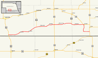
Nebraska Highway 89 is a highway in southern Nebraska. Its western terminus is at U.S. Highway 83 west of Danbury. Its eastern terminus is at an intersection with U.S. Highway 183 south of Alma.

Nebraska Highway 91 is a highway in central and eastern Nebraska. Its western terminus is at an intersection with Nebraska Highway 2 north of Dunning. Its eastern terminus is at an intersection with U.S. Highway 30 and U.S. Highway 75 in Blair.

