Blue Hill, Nebraska

Last updated

Blue Hill, Nebraska
Blue Hill, Nebraska downtown 2.JPG
Downtown Blue Hill: north side of West Gage Street, May 2010
Webster County Nebraska Incorporated and Unincorporated areas Blue Hill Highlighted.svg
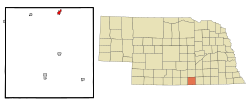
Location of Blue Hill, Nebraska
Coordinates: 40°19′59″N98°26′54″W / 40.33306°N 98.44833°W / 40.33306; -98.44833
Country United States
State Nebraska
County Webster
Area
[1]
  Total0.73 sq mi (1.90 km2)
  Land0.73 sq mi (1.90 km2)
  Water0.00 sq mi (0.00 km2)
Elevation
[2]
1,972 ft (601 m)
Population
 (2020)
  Total805
  Density1,098.23/sq mi (423.83/km2)
Time zone UTC-6 (Central (CST))
  Summer (DST) UTC-5 (CDT)
ZIP code
68930
Area code 402
FIPS code 31-05560 [3]
GNIS feature ID2394202 [2]
Website http://bluehillne.com/

Blue Hill is a town in Webster County, Nebraska, United States. The population was 936 at the 2010 census. Mayor- Kirsten Schofield

Contents

History

Blue Hill was originally called Belmont, and under the latter name was platted in 1878 when the Burlington and Missouri River Railroad was extended to that point. [4] [5] When it was discovered that another Belmont in the state existed, the name was changed to Blue Hill. [6] The present name alludes to the nearby Blue River. [7]

The Blue Hill Country Club was built in late 50's early 60's by Axel E. Ohlin and son Dale R. Ohlin from nearby Hastings Nebraska.

Geography

According to the United States Census Bureau, the city has a total area of 0.73 square miles (1.89 km2), all land. [8] Blue Hill is situated 22.5 miles north of the Nebraska-Kansas state line and is 150 miles west of the Missouri River. [9]

Climate

Climate data for Blue Hill, Nebraska (coordinates: 40°18′21″N98°30′17″W / 40.3058°N 98.5047°W / 40.3058; -98.5047 , 1991-2020)
MonthJanFebMarAprMayJunJulAugSepOctNovDecYear
Average precipitation inches (mm)0.65
(17)
0.80
(20)
1.47
(37)
2.60
(66)
4.57
(116)
3.61
(92)
3.92
(100)
3.48
(88)
2.32
(59)
2.05
(52)
1.26
(32)
0.85
(22)
27.58
(701)
Average snowfall inches (cm)5.7
(14)
7.8
(20)
3.2
(8.1)
1.4
(3.6)
0.0
(0.0)
0.0
(0.0)
0.0
(0.0)
0.0
(0.0)
0.0
(0.0)
1.2
(3.0)
1.6
(4.1)
4.4
(11)
25.3
(63.8)
Average precipitation days (≥ 0.01 in)3.43.75.27.19.27.96.76.44.94.93.73.366.4
Average snowy days (≥ 0.01 in)2.72.91.40.8000000.31.32.311.7
Source: NOAA [10]

Government

Blue Hill's local government consists of one mayor and five board members who hold meetings on the second Tuesday of every month. As of January 2011, the mayor is Keri Schunk. [11]

Demographics

Historical population
CensusPop.Note
1880 138
1890 796476.8%
1900 8233.4%
1910 761−7.5%
1920 726−4.6%
1930 669−7.9%
1940 565−15.5%
1950 5741.6%
1960 72326.0%
1970 7848.4%
1980 88312.6%
1990 810−8.3%
2000 8677.0%
2010 9368.0%
2020 805−14.0%
U.S. Decennial Census [12]

2010 census

As of the census [13] of 2010, there were 936 people, 363 households, and 228 families residing in the city. The population density was 1,282.2 inhabitants per square mile (495.1/km2). There were 392 housing units at an average density of 537.0 per square mile (207.3/km2). The racial makeup of the city was 97.4% White, 0.6% African American, 0.1% Native American, 0.2% Asian, 0.1% Pacific Islander, 0.1% from other races, and 1.4% from two or more races. Hispanic or Latino of any race were 1.8% of the population.

There were 363 households, of which 32.8% had children under the age of 18 living with them, 52.1% were married couples living together, 8.0% had a female householder with no husband present, 2.8% had a male householder with no wife present, and 37.2% were non-families. 34.4% of all households were made up of individuals, and 22% had someone living alone who was 65 years of age or older. The average household size was 2.37 and the average family size was 3.04.

The median age in the city was 44.1 years. 25.4% of residents were under the age of 18; 6.5% were between the ages of 18 and 24; 20% were from 25 to 44; 26.2% were from 45 to 64; and 22% were 65 years of age or older. The gender makeup of the city was 45.2% male and 54.8% female.

2000 census

As of the census [3] of 2000, there were 867 people, 350 households, and 231 families residing in the city. The population density was 1,178.3 inhabitants per square mile (454.9/km2). There were 392 housing units at an average density of 532.8 per square mile (205.7/km2). The racial makeup of the city was 97.81% White, 0.35% African American, 0.46% Native American, 0.69% Asian, 0.46% from other races, and 0.23% from two or more races. Hispanic or Latino of any race were 0.81% of the population.

There were 350 households, out of which 26.0% had children under the age of 18 living with them, 58.9% were married couples living together, 4.6% had a female householder with no husband present, and 34.0% were non-families. 32.6% of all households were made up of individuals, and 20.6% had someone living alone who was 65 years of age or older. The average household size was 2.26 and the average family size was 2.85.

In the city, the population was spread out, with 20.8% under the age of 18, 5.2% from 18 to 24, 21.3% from 25 to 44, 22.6% from 45 to 64, and 30.1% who were 65 years of age or older. The median age was 47 years. For every 100 females there were 82.9 males. For every 100 females age 18 and over, there were 78.9 males.

As of 2000 the median income for a household in the city was $30,938, and the median income for a family was $43,500. Males had a median income of $29,167 versus $19,904 for females. The per capita income for the city was $15,733. About 8.1% of families and 10.4% of the population were below the poverty line, including 16.4% of those under age 18 and 11.4% of those age 65 or over.

See also

Related Research Articles

<span class="mw-page-title-main">Roseland, Nebraska</span> Village in Nebraska, United States

Roseland is a village in Adams County, Nebraska, United States. The population was 260 at the 2020 census. It is part of the Hastings, Nebraska Micropolitan Statistical Area.

<span class="mw-page-title-main">Edgar, Nebraska</span> City in Nebraska, United States

Edgar is a city in Clay County, Nebraska, United States. The population was 498 at the 2010 census. It is part of the Hastings, Nebraska Micropolitan Statistical Area.

<span class="mw-page-title-main">Sutton, Nebraska</span> City in Nebraska, United States

Sutton is a city in Clay County, Nebraska, United States. The population was 1,447 at the 2020 census. It is part of the Hastings, Nebraska Micropolitan Statistical Area.

<span class="mw-page-title-main">Ponca, Nebraska</span> City in and county seat of Dixon County, Nebraska, U.S.

Ponca is a city and county seat of Dixon County, Nebraska, United States. The population was 961 at the 2010 census.

<span class="mw-page-title-main">Bennington, Nebraska</span> City in Douglas County, Nebraska, United States

Bennington is a city in Douglas County, Nebraska, United States. The population was 2,026 at the 2020 U.S. Census.

<span class="mw-page-title-main">Ralston, Nebraska</span> City in Douglas County, Nebraska, United States

Ralston is a city in Douglas County, Nebraska, United States. The population was 6,494 at the 2020 census. A suburb of Omaha, Ralston is surrounded on three sides by the city of Omaha by 84th, 72nd, and L Streets, and by Sarpy County on the south side.

<span class="mw-page-title-main">Blue Springs, Nebraska</span> City in Nebraska, United States

Blue Springs is a city in Gage County, Nebraska, United States. The population was 282 at the 2020 census.

<span class="mw-page-title-main">Atkinson, Nebraska</span> City in Nebraska, United States

Atkinson is a city in Holt County, Nebraska, United States. The population was 1,245 at the 2010 census.

<span class="mw-page-title-main">Waverly, Nebraska</span> Village in Nebraska, United States

Waverly is a village in Lancaster County, Nebraska, United States. It is part of the Lincoln, Nebraska Metropolitan Statistical Area. The population was 4,279 at the 2020 census.

<span class="mw-page-title-main">Nelson, Nebraska</span> Village in Nebraska, United States

Nelson is a village and the county seat of Nuckolls County, Nebraska, United States. The population was 488 at the 2010 census. The city was named for C. Nelson Wheeler, the original owner of the town site.

<span class="mw-page-title-main">Syracuse, Nebraska</span> City in Nebraska, United States

Syracuse is a city in Otoe County, Nebraska, United States. The population was 1,957 at the 2022 census.

<span class="mw-page-title-main">Humphrey, Nebraska</span> City in Platte County, Nebraska, United States

Humphrey is a city in Platte County, Nebraska, United States. The population was 760 at the 2010 census.

<span class="mw-page-title-main">Crete, Nebraska</span> City in Saline County, Nebraska, United States

Crete is a city in and the most populous municipality of Saline County, Nebraska, United States. The population was 7,099 at the 2020 census. The city is home to Doane University.

<span class="mw-page-title-main">Wilber, Nebraska</span> City in Saline County, Nebraska, United States

Wilber is a city in and the county seat of Saline County, Nebraska, United States. The population was 1,855 at the 2010 census. It is the county seat of Saline County. Wilber is the official "Czech Capital of the USA" and hosts an annual Czech festival in August. Wilber's school is the Wilber-Clatonia High School.

<span class="mw-page-title-main">Bellevue, Nebraska</span> City in Sarpy County, Nebraska, United States

Bellevue is a suburban city in Sarpy County, Nebraska, United States. It is part of the Omaha–Council Bluffs metropolitan area, and had a population of 64,176 as of the 2020 census, making it the 3rd most populous city in Nebraska, behind Omaha and Lincoln, and the second largest city in the U.S. named "Bellevue," behind Bellevue, Washington.

<span class="mw-page-title-main">Seward, Nebraska</span> City in and county seat of Seward County, Nebraska, United States

Seward is a city and county seat of Seward County, Nebraska, United States. The population was 7,643 at the 2020 census. Seward is part of the Lincoln, Nebraska Metropolitan Statistical Area.

<span class="mw-page-title-main">Walthill, Nebraska</span> Village in Thurston County, Nebraska, United States

Walthill is a village in Thurston County, Nebraska, United States, within the Omaha Reservation. The population was 780 at the 2010 census.

<span class="mw-page-title-main">Fort Calhoun, Nebraska</span> City in Washington County, Nebraska, United States

Fort Calhoun is a city in Washington County, Nebraska, United States. The population was 1,108 at the 2020 census. The city includes Fort Atkinson, the first fort built west of the Missouri River.

<span class="mw-page-title-main">North Hills, West Virginia</span> Town in West Virginia, United States

North Hills is a town in Wood County, West Virginia, United States. It is a suburb of Parkersburg. The population was 837 at the 2020 census. North Hills was incorporated on February 15, 1979.

<span class="mw-page-title-main">Wakefield, Nebraska</span> City in Dixon and Wayne counties in Nebraska, United States

Wakefield is a city in Dixon and Wayne Counties in the State of Nebraska. The population was 1,451 at the 2010 census.

References

  1. "ArcGIS REST Services Directory". United States Census Bureau. Retrieved September 18, 2022.
  2. 1 2 U.S. Geological Survey Geographic Names Information System: Blue Hill, Nebraska
  3. 1 2 "U.S. Census website". United States Census Bureau . Retrieved January 31, 2008.
  4. Burr, George L. (1921). History of Hamilton and Clay Counties, Nebraska, Volume 1. S.J. Clarke Publishing Company. p. 141.
  5. "Blue Hill, Webster County". Center for Advanced Land Management Information Technologies. University of Nebraska. Archived from the original on December 4, 2021. Retrieved August 24, 2014.
  6. "History of Blue Hill". City of Blue Hill, NE. Archived from the original on July 28, 2014. Retrieved August 24, 2014.
  7. Federal Writers' Project (1938). Origin of Nebraska place names. Lincoln, NE: Works Progress Administration. p. 7.
  8. "US Gazetteer files 2010". United States Census Bureau. Archived from the original on January 25, 2012. Retrieved June 24, 2012.
  9. "City of Blue Hill". Archived from the original on July 28, 2014. Retrieved August 24, 2014. Retrieved 2011-1-30
  10. "Station: BLUE HILL 4 SW, NE US USC00250961" (PDF). Summary of Monthly Normals 1991-2020. National Centers for Environmental Information. pp. 1, 2. Retrieved November 9, 2024.
  11. "City of Blue Hill". Archived from the original on July 8, 2011. Retrieved January 30, 2011. Retrieved 2011-1-30
  12. "Census of Population and Housing". Census.gov. Retrieved June 4, 2015.
  13. "U.S. Census website". United States Census Bureau . Retrieved June 24, 2012.

Commons-logo.svg Media related to Blue Hill, Nebraska at Wikimedia Commons