York County, Nebraska

Last updated

York County
County of York
York County Courthouse (Nebraska) 3.jpg
York County Courthouse in York
York County, Nebraska
Interactive map of York County
Map of Nebraska highlighting York County.svg
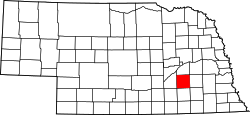
Location within the U.S. state of Nebraska
CountryFlag of the United States.svg  United States
State Flag of Nebraska.svg  Nebraska
EstablishedMarch 16, 1855
OrganizedApril 26, 1870
County seat York
Largest cityYork
Area
  Total576 sq mi (1,490 km2)
  Land573 sq mi (1,480 km2)
  Water3.3 sq mi (9 km2)  0.6%
Highest elevation
1,598 ft (487 m)
Lowest elevation
1,066 ft (325 m)
Population
 (2020)
  Total14,125
  Density25/sq mi (9.5/km2)
Time zone UTC−6 (Central)
  Summer (DST) UTC−5 (CDT)
Area code 402/531
FIPS code31185
GNIS feature ID 835914
Website www.yorkcounty.ne.gov

York County is a county in the U.S. state of Nebraska. As of the 2020 United States Census, the population was 14,125. [1] Its county seat is York. [2]

Contents

In the Nebraska license plate system, York County is represented by the prefix 17 (it had the seventeenth-largest number of vehicles registered in the county when the license plate system was established in 1922).

History

York County was organized in 1870. Sources differ on the origin of the county's name: some state it was named after York in England, while others maintain it was named by early settlers from York County, Pennsylvania. [3]

Geography

The terrain of York County consists of rolling prairie, mostly devoted to agriculture. The ground slopes toward the Platte River, to the northwest. The county has a total area of 576 square miles (1,490 km2), of which 573 square miles (1,480 km2) is land and 3.3 square miles (8.5 km2) (0.6%) is water. [4]

Major highways

Adjacent counties

Protected areas

  • Kirkpatrick Basin North State Wildlife Area [5]
  • Kirkpatrick Basin South State Wildlife Area [6]
  • Renquist Basin State Wildlife Management Area [7]
  • Waco Waterfowl Production Area [8]

Demographics

Historical population
CensusPop.Note
1870 604
1880 11,1701,749.3%
1890 17,27954.7%
1900 18,2055.4%
1910 18,7212.8%
1920 17,146−8.4%
1930 17,2390.5%
1940 14,874−13.7%
1950 14,346−3.5%
1960 13,724−4.3%
1970 13,685−0.3%
1980 14,7988.1%
1990 14,428−2.5%
2000 14,5981.2%
2010 13,665−6.4%
2020 14,1253.4%
US Decennial Census [9]
1790-1960 [10] 1900-1990 [11]
1990-2000 [12] 2010 [13]

As of the 2000 United States Census, [14] there were 14,598 people, 5,722 households, and 3,931 families in the county. The population density was 25 people per square mile (9.7 people/km2). There were 6,172 housing units at an average density of 11 per square mile (4.2/km2). The racial makeup of the county was 96.78% White, 0.96% Black or African American, 0.29% Native American, 0.49% Asian, 0.08% Pacific Islander, 0.64% from other races, and 0.77% from two or more races. 1.40% of the population were Hispanic or Latino of any race. 52.0% were of German, 8.2% Irish, 7.2% English and 5.1% Swedish ancestry.

There were 5,722 households, out of which 31.10% had children under the age of 18 living with them, 60.20% were married couples living together, 6.00% had a female householder with no husband present, and 31.30% were non-families. 27.50% of all households were made up of individuals, and 14.00% had someone living alone who was 65 years of age or older. The average household size was 2.42 and the average family size was 2.96.

The county population contained 25.30% under the age of 18, 9.00% from 18 to 24, 25.40% from 25 to 44, 23.00% from 45 to 64, and 17.40% who were 65 years of age or older. The median age was 39 years. For every 100 females there were 91.50 males. For every 100 females age 18 and over, there were 88.80 males.

The median income for a household in the county was $37,093, and the median income for a family was $44,741. Males had a median income of $30,658 versus $19,874 for females. The per capita income for the county was $17,670. About 6.00% of families and 8.50% of the population were below the poverty line, including 9.90% of those under age 18 and 7.10% of those age 65 or over.

Communities

Cities

Villages

Former Communities

Government

The County Board of Commissioners is the executive and legislative authority of the county. [15]

Politics

York County voters have traditionally been strong Republicans. In only one national election since 1916 has the county selected the Democratic Party candidate (as of 2020).

United States presidential election results for York County, Nebraska [16]
Year Republican Democratic Third party
No.%No.%No.%
2020 5,33774.53%1,63022.76%1942.71%
2016 4,70073.66%1,18618.59%4957.76%
2012 4,87476.70%1,37321.61%1081.70%
2008 4,84873.81%1,60724.47%1131.72%
2004 5,39379.34%1,30419.18%1001.47%
2000 4,81674.55%1,40721.78%2373.67%
1996 4,26665.56%1,65325.40%5889.04%
1992 3,78353.94%1,38519.75%1,84526.31%
1988 4,76572.78%1,75126.75%310.47%
1984 5,14782.08%1,12417.92%00.00%
1980 5,08976.71%1,13117.05%4146.24%
1976 4,22369.62%1,66527.45%1782.93%
1972 4,65177.92%1,31822.08%00.00%
1968 3,92372.39%1,23722.83%2594.78%
1964 3,41054.63%2,83245.37%00.00%
1960 5,20574.69%1,76425.31%00.00%
1956 5,06576.35%1,56923.65%00.00%
1952 5,74279.64%1,46820.36%00.00%
1948 3,96065.44%2,09134.56%00.00%
1944 4,88572.99%1,80827.01%00.00%
1940 5,32270.75%2,20029.25%00.00%
1936 4,55454.12%3,74144.46%1201.43%
1932 3,57347.14%3,92051.72%861.13%
1928 5,76974.16%1,97925.44%310.40%
1924 4,11058.66%1,77825.37%1,11915.97%
1920 4,26566.87%1,85729.12%2564.01%
1916 2,01146.22%2,20650.70%1343.08%
1912 96223.40%1,88645.88%1,26330.72%
1908 2,20950.39%2,04246.58%1333.03%
1904 2,52964.16%75419.13%65916.72%
1900 2,20753.05%1,87144.98%821.97%

See also

Related Research Articles

<span class="mw-page-title-main">Clay County, Nebraska</span> County in Nebraska, United States

Clay County is a county in the U.S. state of Nebraska. As of the 2020 United States Census, the population was 6,104. Its county seat is Clay Center. The county was formed in 1855, and was organized in 1871. It was named for Henry Clay, a member of the United States Senate from Kentucky, who went on to become United States Secretary of State.

<span class="mw-page-title-main">Webster County, Nebraska</span> County in Nebraska, United States

Webster County is a county in the U.S. state of Nebraska. As of the 2020 United States Census, the population was 3,411. Its county seat is Red Cloud. The county was formed in 1871, and was named for Daniel Webster.

<span class="mw-page-title-main">Thayer County, Nebraska</span> County in Nebraska, United States

Thayer County is a county in the U.S. state of Nebraska. As of the 2020 United States Census, the population was 5,034. The county was created in 1856 and originally named Jefferson County. It was organized in 1870-1871 and renamed for General and Governor John Milton Thayer.

<span class="mw-page-title-main">Stanton County, Nebraska</span> County in Nebraska, United States

Stanton County is a county in the U.S. state of Nebraska. As of the 2020 United States Census, the population was 5,842. Its county seat is Stanton. The county was formed in 1856 and organized in 1867. It was first called Izard County until 1862, when it was renamed for Edwin M. Stanton, Secretary of War during the administration of President Abraham Lincoln.

<span class="mw-page-title-main">Sioux County, Nebraska</span> County in Nebraska, United States

Sioux County is a county in the U.S. state of Nebraska. As of the 2020 United States Census, the population was 1,135. Its county seat is Harrison.

<span class="mw-page-title-main">Seward County, Nebraska</span> County in Nebraska, United States

Seward County is a county in the U.S. state of Nebraska, United States. As of the 2020 United States Census, the population was 17,609. Its county seat is Seward. The county was formed in 1855, and was organized in 1867. It was originally called Greene County, and in 1862 it was renamed for William H. Seward, Secretary of State under Abraham Lincoln and Andrew Johnson. Seward County is part of the Lincoln, NE Metropolitan Statistical Area.

<span class="mw-page-title-main">Saunders County, Nebraska</span> County in Nebraska, United States

Saunders County is a county in the U.S. state of Nebraska. As of the 2020 United States Census, the population was 22,278. Its county seat is Wahoo.

<span class="mw-page-title-main">Red Willow County, Nebraska</span> County in Nebraska, United States

Red Willow County is a county located in the U.S. state of Nebraska. As of the 2020 United States Census, the population was 10,702. Its county seat is McCook.

<span class="mw-page-title-main">Pawnee County, Nebraska</span> County in Nebraska, United States

Pawnee County is a county in the U.S. state of Nebraska. As of the 2020 United States Census, the population was 2,544. Its county seat is Pawnee City.

<span class="mw-page-title-main">Madison County, Nebraska</span> County in Nebraska, United States

Madison County is a county in the U.S. state of Nebraska. As of the 2020 United States Census, the population was 35,585. Its county seat is Madison and its largest city is Norfolk. Madison County was named for James Madison, fourth President of the United States.

<span class="mw-page-title-main">Lincoln County, Nebraska</span> County in Nebraska, United States

Lincoln County is a county located in the U.S. state of Nebraska. As of the 2020 census, the population was 34,676. Its county seat is North Platte. Despite the county's name, the state capital city of Lincoln is not in or near Lincoln County. The city of Lincoln is, instead, located more than 200 miles further to the east in Lancaster County.

<span class="mw-page-title-main">Kearney County, Nebraska</span> County in Nebraska, United States

Kearney County is a county located in the U.S. state of Nebraska. As of the 2020 United States Census, the population was 6,688. Its county seat is Minden. The county was formed in 1860. It was named for Fort Kearny, which in turn was named for Brigade General Stephen W. Kearny.

<span class="mw-page-title-main">Jefferson County, Nebraska</span> County in Nebraska, United States

Jefferson County is a county in the U.S. state of Nebraska. As of the 2020 United States Census, the population was 7,240. Its county seat is Fairbury. The county was named for Thomas Jefferson, third President of the United States of America.

<span class="mw-page-title-main">Harlan County, Nebraska</span> County in Nebraska, United States

Harlan County is a county in the U.S. state of Nebraska. As of the 2020 United States Census, the population was 3,073. Its county seat is Alma. The county is home to the Harlan County Reservoir.

<span class="mw-page-title-main">Hamilton County, Nebraska</span> County in Nebraska, United States

Hamilton County is a county in the U.S. state Nebraska. As of the 2020 United States Census, the population was 9,429. Its county seat is Aurora. The county was named for Alexander Hamilton, the first Secretary of the Treasury in the new United States government.

<span class="mw-page-title-main">Hall County, Nebraska</span> County in Nebraska, United States

Hall County is a county in the U.S. state of Nebraska. As of the 2020 United States Census, the population was 62,895, making it Nebraska's fourth-most populous county. Its county seat is Grand Island. The county was formed in 1858; it was named for Augustus Hall, an early judge of this territory.

<span class="mw-page-title-main">Gosper County, Nebraska</span> County in Nebraska, United States

Gosper County is a county located in the U.S. state of Nebraska. As of the 2020 United States census, the population was 1,893. Its county seat is Elwood. The county was formed in 1873, and was organized in 1881. It was named for John J. Gosper, a Nebraska Secretary of State.

<span class="mw-page-title-main">Fillmore County, Nebraska</span> County in Nebraska, United States

Fillmore County is a county located in the U.S. state of Nebraska. As of the 2020 United States Census, the population was 5,551. Its county seat is Geneva. The county was named for President Millard Fillmore.

<span class="mw-page-title-main">Cedar County, Nebraska</span> County in Nebraska, United States

Cedar County is a county in the U.S. state of Nebraska. As of the 2020 United States Census, the population was 8,380. The county seat is Hartington. The county was formed in 1857, and was named for the Cedar tree groves in the area.

<span class="mw-page-title-main">Butler County, Nebraska</span> County in Nebraska, United States

Butler County is a county in the U.S. state of Nebraska. As of the 2020 United States Census, the population was 8,369. Its county seat is David City. The county was created in 1856 and organized in 1868.

References

  1. "York County, Nebraska". United States Census Bureau . Retrieved June 24, 2023.
  2. "Find a County". National Association of Counties. Archived from the original on May 31, 2011. Retrieved June 7, 2011.
  3. Perkey, Elton A. Perkey's Nebraska Place Names. Revised edition, 2003. Nebraska State Historical Society. p. 191.
  4. "2010 Census Gazetteer Files". US Census Bureau. August 22, 2012. Archived from the original on November 13, 2013. Retrieved December 12, 2014.
  5. Kirkpatrick Basin North State Wildlife Management Area, York NE Google Maps (accessed 23 January 2019)
  6. Kirkpatrick Basin South State Wildlife Management Area, Henderson NE Google Maps (accessed 23 January 2019)
  7. Renquist Basin State Wildlife Management Area, Bradshaw NE Google Maps (accessed 23 January 2019)
  8. Waco Waterfowl Production Area, Waco NE Google Maps (accessed 23 January 2019)
  9. "US Decennial Census". US Census Bureau. Retrieved December 12, 2014.
  10. "Historical Census Browser". University of Virginia Library. Retrieved December 12, 2014.
  11. "Population of Counties by Decennial Census: 1900 to 1990". US Census Bureau. Retrieved December 12, 2014.
  12. "Census 2000 PHC-T-4. Ranking Tables for Counties: 1990 and 2000" (PDF). US Census Bureau. Archived (PDF) from the original on March 27, 2010. Retrieved December 12, 2014.
  13. "State & County QuickFacts". US Census Bureau. Retrieved September 22, 2013.
  14. "U.S. Census website". US Census Bureau. Retrieved January 31, 2008.
  15. "Board of Commissioners". Archived October 14, 2013, at the Wayback Machine York County, Nebraska. Archived June 22, 2013, at the Wayback Machine
  16. Election Results

40°52′N97°36′W / 40.87°N 97.60°W / 40.87; -97.60