National Register of Historic Places listings in Saunders County, Nebraska

Last updated

Location of Saunders County in Nebraska Map of Nebraska highlighting Saunders County.svg
Location of Saunders County in Nebraska

This is a list of the National Register of Historic Places listings in Saunders County, Nebraska. It is intended to be a complete list of the properties and districts on the National Register of Historic Places in Saunders County, Nebraska, United States. The locations of National Register properties and districts for which the latitude and longitude coordinates are included below, may be seen in a map. [1]

Contents

There are 22 properties and districts listed on the National Register in the county.


    This National Park Service list is complete through NPS recent listings posted December 9, 2022. [2]

Map all coordinates using: OpenStreetMap  
Download coordinates as: KML

Listings county-wide

[3] Name on the RegisterImageDate listed [4] Location City or townDescription
1 Ashland Archeological District November 29, 2000
(#00001376)
Address Restricted
Ashland
2 Ashland Bridge
Ashland Bridge Ashland bridge from NE.JPG
Ashland Bridge
June 29, 1992
(#92000721)
Silver St. over Salt Creek
41°02′21″N96°21′52″W / 41.0391°N 96.3645°W / 41.0391; -96.3645 (Ashland Bridge)
Ashland One of 2 surviving Warren pony truss bridges in Nebraska
3 Ashland Public Library
Ashland Public Library Ashland library from NW 2.JPG
Ashland Public Library
January 27, 1983
(#83001102)
207 N. 15th St.
41°02′27″N96°22′08″W / 41.0408°N 96.3689°W / 41.0408; -96.3689 (Ashland Public Library)
Ashland
4 Barnes Oil Company
Barnes Oil Company Barnes Oil Co 2.jpg
Barnes Oil Company
December 5, 2002
(#02001475)
Junction of Silver St. and U.S. Route 6
41°02′20″N96°21′26″W / 41.0389°N 96.3572°W / 41.0389; -96.3572 (Barnes Oil Company)
Ashland
5 Israel Beetison House
Israel Beetison House School 58 Saunders County Nebraska.jpg
Israel Beetison House
April 18, 1977
(#77000839)
Southeast of Ashland
41°01′54″N96°21′12″W / 41.0317°N 96.3533°W / 41.0317; -96.3533 (Israel Beetison House)
Ashland
6 Camp Ashland Memorial Hall March 11, 2021
(#100006287)
220 Cty. Rd. A (Camp Ashland)
41°03′46″N96°20′06″W / 41.0627°N 96.3350°W / 41.0627; -96.3350 (Camp Ashland Memorial Hall)
Ashland
7 Howard Hanson House
Howard Hanson House Howard Hanson House from SE 1.JPG
Howard Hanson House
January 27, 1983
(#83001103)
12th and Linden Sts.
41°12′59″N96°37′07″W / 41.2164°N 96.6186°W / 41.2164; -96.6186 (Howard Hanson House)
Wahoo
8 Hoffman Building
Hoffman Building Ashland Hoffman bldg from NW 3.jpg
Hoffman Building
November 21, 2014
(#14000441)
1325 & 1341 Silver St.
41°02′20″N96°22′06″W / 41.0389°N 96.3682°W / 41.0389; -96.3682 (Hoffman Building)
Ashland
9 Old Ithaca Grain Elevator
Old Ithaca Grain Elevator Old Ithaca, Nebraska grain elevator from SE.JPG
Old Ithaca Grain Elevator
February 23, 2001
(#01000168)
One block south of 4th St.
41°09′27″N96°32′19″W / 41.1575°N 96.5386°W / 41.1575; -96.5386 (Old Ithaca Grain Elevator)
Ithaca
10 Kacirek-Woita General Store
Kacirek-Woita General Store Vintage Merchant General Store from W 2.jpg
Kacirek-Woita General Store
July 8, 2014
(#14000397)
250 N. Elm St.
41°11′30″N96°44′36″W / 41.1918°N 96.7433°W / 41.1918; -96.7433 (Kacirek-Woita General Store)
Weston
11 F.J. Kirchman House
F.J. Kirchman House Kirchman House (Wahoo, Nebraska) from NE 2.JPG
F.J. Kirchman House
August 21, 2003
(#03000796)
957 Beech St.
41°12′52″N96°37′02″W / 41.2144°N 96.6172°W / 41.2144; -96.6172 (F.J. Kirchman House)
Wahoo
12 Leshara Site March 16, 1972
(#72000759)
Address Restricted
Leshara
13 McClean Site March 16, 1972
(#72000758)
Address Restricted
Inglewood
14 National Bank of Ashland
National Bank of Ashland National Bank of Ashland from SW.jpg
National Bank of Ashland
January 27, 1983
(#83001104)
1442 Silver St.
41°02′21″N96°22′09″W / 41.0392°N 96.3692°W / 41.0392; -96.3692 (National Bank of Ashland)
Ashland
15 O.K. Market
O.K. Market OK Market (Wahoo, Nebraska) 1.jpg
O.K. Market
July 3, 1991
(#91000835)
542 N. Linden Ave.
41°12′38″N96°36′23″W / 41.2106°N 96.6064°W / 41.2106; -96.6064 (O.K. Market)
Wahoo
16 Pahuk
Pahuk Pahuk from S 2.JPG
Pahuk
August 14, 1973
(#73001074)
Address Restricted
Cedar Bluffs
17 Rad Plzen cis. 9 Z.C.B.J. (SD10-6)
Rad Plzen cis. 9 Z.C.B.J. (SD10-6) Morse Bluff, Nebraska ZCBJ from NW 1.jpg
Rad Plzen cis. 9 Z.C.B.J. (SD10-6)
March 20, 1986
(#86000440)
Off Nebraska Highway 79
41°25′52″N96°45′58″W / 41.4311°N 96.7661°W / 41.4311; -96.7661 (Rad Plzen cis. 9 Z.C.B.J. (SD10-6))
Morse Bluff
18 St. Stephen's Episcopal Church
St. Stephen's Episcopal Church Ashland St. Stephens Episcopal from SE 1.jpg
St. Stephen's Episcopal Church
January 25, 1979
(#79001454)
16th and Adams Sts. [5]
41°02′25″N96°22′16″W / 41.0403°N 96.3711°W / 41.0403; -96.3711 (St. Stephen's Episcopal Church)
Ashland
19 Saunders County Courthouse
Saunders County Courthouse Saunders County Courthouse.jpg
Saunders County Courthouse
January 10, 1990
(#89002220)
Chestnut between 4th and 5th Sts.
41°12′34″N96°37′24″W / 41.2095°N 96.6232°W / 41.2095; -96.6232 (Saunders County Courthouse)
Wahoo
20 Wahoo Burlington Depot
Wahoo Burlington Depot Wahoo Burlington Depot from S 2.JPG
Wahoo Burlington Depot
May 9, 1985
(#85000955)
431 W. 3rd
41°12′27″N96°36′44″W / 41.2075°N 96.6122°W / 41.2075; -96.6122 (Wahoo Burlington Depot)
Wahoo
21 Woodcliff Burials March 7, 1973
(#73001075)
Address Restricted
Inglewood
22 Yutan Site June 26, 1972
(#72000760)
Address Restricted
Yutan

See also

Related Research Articles

<span class="mw-page-title-main">National Register of Historic Places listings in Newport News, Virginia</span>

This is a list of the National Register of Historic Places listings in Newport News, Virginia.

<span class="mw-page-title-main">National Register of Historic Places listings in Webster County, Nebraska</span>

This is a list of the National Register of Historic Places listings in Webster County, Nebraska. It is intended to be a complete list of the properties and districts on the National Register of Historic Places in Webster County, Nebraska, United States. The locations of National Register properties and districts for which the latitude and longitude coordinates are included below, may be seen in a map.

<span class="mw-page-title-main">National Register of Historic Places listings in Scotts Bluff County, Nebraska</span>

This is a list of the National Register of Historic Places listings in Scotts Bluff County, Nebraska.

<span class="mw-page-title-main">National Register of Historic Places listings in Platte County, Nebraska</span>

This is a list of the National Register of Historic Places listings in Platte County, Nebraska. It is intended to be a complete list of the properties and districts on the National Register of Historic Places in Platte County, Nebraska, United States. The locations of National Register properties and districts for which the latitude and longitude coordinates are included below, may be seen in a map.

<span class="mw-page-title-main">National Register of Historic Places listings in Nemaha County, Nebraska</span>

This is a list of the National Register of Historic Places listings in Nemaha County, Nebraska. It is intended to be a complete list of the properties and districts on the National Register of Historic Places in Nemaha County, Nebraska, United States. The locations of National Register properties and districts for which the latitude and longitude coordinates are included below, may be seen in a map.

<span class="mw-page-title-main">National Register of Historic Places listings in Cedar County, Nebraska</span>

This is a list of the National Register of Historic Places listings in Cedar County, Nebraska.

<span class="mw-page-title-main">National Register of Historic Places listings in Cheyenne County, Nebraska</span>

This is a list of the National Register of Historic Places listings in Cheyenne County, Nebraska. It is intended to be a complete list of the properties and districts on the National Register of Historic Places in Cheyenne County, Nebraska, United States. The locations of National Register properties and districts for which the latitude and longitude coordinates are included below, may be seen in a map.

<span class="mw-page-title-main">National Register of Historic Places listings in Jefferson County, Nebraska</span>

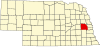
This is a list of the National Register of Historic Places listings in Jefferson County, Nebraska. It is intended to be a complete list of the properties and districts on the National Register of Historic Places in Jefferson County, Nebraska, United States. The locations of National Register properties and districts for which the latitude and longitude coordinates are included below, may be seen in a map.

<span class="mw-page-title-main">National Register of Historic Places listings in Butler County, Nebraska</span>

This is a list of the National Register of Historic Places listings in Butler County, Nebraska. It is intended to be a complete list of the properties and districts on the National Register of Historic Places in Butler County, Nebraska, United States. The locations of National Register properties and districts for which the latitude and longitude coordinates are included below, may be seen in a map.

<span class="mw-page-title-main">National Register of Historic Places listings in Hall County, Nebraska</span>

This is a list of the National Register of Historic Places listings in Hall County, Nebraska.

<span class="mw-page-title-main">National Register of Historic Places listings in Dodge County, Nebraska</span>

This is a list of the National Register of Historic Places listings in Dodge County, Nebraska.

<span class="mw-page-title-main">National Register of Historic Places listings in Colfax County, Nebraska</span>

This is a list of the National Register of Historic Places listings in Colfax County, Nebraska.

<span class="mw-page-title-main">National Register of Historic Places listings in Burt County, Nebraska</span>

This is a list of the National Register of Historic Places listings in Burt County, Nebraska.

<span class="mw-page-title-main">National Register of Historic Places listings in Merrick County, Nebraska</span>

This is a list of the National Register of Historic Places listings in Merrick County, Nebraska. It is intended to be a complete list of the properties and districts on the National Register of Historic Places in Merrick County, Nebraska, United States. The locations of National Register properties and districts for which the latitude and longitude coordinates are included below, may be seen in a map.

<span class="mw-page-title-main">National Register of Historic Places listings in Seward County, Nebraska</span>

This is a list of the National Register of Historic Places listings in Seward County, Nebraska. It is intended to be a complete list of the properties and districts on the National Register of Historic Places in Seward County, Nebraska, United States. The locations of National Register properties and districts for which the latitude and longitude coordinates are included below, may be seen in a map.

<span class="mw-page-title-main">National Register of Historic Places listings in Lincoln County, Nebraska</span>

This is a list of the National Register of Historic Places listings in Lincoln County, Nebraska. It is intended to be a complete list of the properties and districts on the National Register of Historic Places in Lincoln County, Nebraska, United States. The locations of National Register properties and districts for which the latitude and longitude coordinates are included below, may be seen in a map.

<span class="mw-page-title-main">National Register of Historic Places listings in Red Willow County, Nebraska</span>

This is a list of the National Register of Historic Places listings in Red Willow County, Nebraska.

<span class="mw-page-title-main">National Register of Historic Places listings in Sheridan County, Nebraska</span>

This is a list of the National Register of Historic Places listings in Sheridan County, Nebraska.

<span class="mw-page-title-main">National Register of Historic Places listings in Madison County, Nebraska</span>

This is a list of the National Register of Historic Places listings in Madison County, Nebraska.

<span class="mw-page-title-main">National Register of Historic Places listings in Dawson County, Nebraska</span>

This is a list of the National Register of Historic Places listings in Dawson County, Nebraska.

References

  1. The latitude and longitude information provided in this table was derived originally from the National Register Information System, which has been found to be fairly accurate for about 99% of listings. Some locations in this table may have been corrected to current GPS standards.
  2. National Park Service, United States Department of the Interior, "National Register of Historic Places: Weekly List Actions", retrieved December 9, 2022.
  3. Numbers represent an alphabetical ordering by significant words. Various colorings, defined here, differentiate National Historic Landmarks and historic districts from other NRHP buildings, structures, sites or objects.
  4. The eight-digit number below each date is the number assigned to each location in the National Register Information System database, which can be viewed by clicking the number.
  5. See photo.