National Register of Historic Places listings in Scotts Bluff County, Nebraska

Last updated

Location of Scotts Bluff County in Nebraska Map of Nebraska highlighting Scotts Bluff County.svg
Location of Scotts Bluff County in Nebraska

This is a list of the National Register of Historic Places listings in Scotts Bluff County, Nebraska.

Contents

This is intended to be a complete list of the properties and districts on the National Register of Historic Places in Scotts Bluff County, Nebraska, United States. The locations of National Register properties and districts for which the latitude and longitude coordinates are included below, may be seen in a map. [1]

There are 21 properties and districts listed on the National Register in the county, including 2 National Historic Landmarks.


    This National Park Service list is complete through NPS recent listings posted May 27, 2022. [2]

Map all coordinates using: OpenStreetMap  
Download coordinates as: KML

Current listings

[3] Name on the RegisterImageDate listed [4] Location City or townDescription
1 Fontenelle Apartment House
Fontenelle Apartment House Fontenelle Apartments (Scottsbluff, NE) from E 1.JPG
Fontenelle Apartment House
July 23, 1998
(#98000891)
1424 4th Ave.
41°51′40″N103°39′27″W / 41.86116°N 103.6575°W / 41.86116; -103.6575 (Fontenelle Apartment House)
Scottsbluff
2 Fort Mitchell Site
Fort Mitchell Site Fort Mitchell, Nebraska historical marker 3.JPG
Fort Mitchell Site
June 7, 1978
(#78001713)
Southwest of Scottsbluff [5]
41°50′30″N103°43′50″W / 41.8417°N 103.7306°W / 41.8417; -103.7306 (Fort Mitchell Site)
Scottsbluff
3 Gering Courier Building
Gering Courier Building Gering Courier from NW 1.JPG
Gering Courier Building
October 15, 2004
(#04000799)
1428 10th St.
41°49′23″N103°39′34″W / 41.823056°N 103.659444°W / 41.823056; -103.659444 (Gering Courier Building)
Gering
4 Henry State Aid Bridges
Henry State Aid Bridges Henry State Aid bridges S bridge span from SW.JPG
Henry State Aid Bridges
June 29, 1992
(#92000732)
North Platte River south of Henry
41°59′27″N104°02′50″W / 41.99083°N 104.04714°W / 41.99083; -104.04714 (Henry State Aid Bridges)
Henry
5 Interstate Canal Bridge
Interstate Canal Bridge Interstate Canal (Scotts Bluff County) old bridge 2.JPG
Interstate Canal Bridge
June 29, 1992
(#92000731)
County road over Interstate Canal, 9.3 miles north of Scottsbluff
41°59′50″N103°38′18″W / 41.997222°N 103.638333°W / 41.997222; -103.638333 (Interstate Canal Bridge)
Scottsbluff
6 Knorr-Holden Continuous Corn Plot
Knorr-Holden Continuous Corn Plot Knorr-Holden plots February 2012d.JPG
Knorr-Holden Continuous Corn Plot
June 11, 1992
(#92000703)
Scottsbluff Experiment Station, on Experiment Farm Road about a mile and a half west of Nebraska Highway 71, north of Scottsbluff
41°56′39″N103°42′01″W / 41.94408°N 103.70041°W / 41.94408; -103.70041 (Knorr-Holden Continuous Corn Plot)
Scottsbluff
7 Lincoln Hotel
Lincoln Hotel Lincoln Hotel (Scottsbluff, Nebraska) from NW 2.JPG
Lincoln Hotel
March 5, 1998
(#98000187)
1421 Broadway
41°51′40″N103°39′43″W / 41.861111°N 103.661944°W / 41.861111; -103.661944 (Lincoln Hotel)
Scottsbluff
8 Marquis Opera House
Marquis Opera House Marquis Opera House (Scottsbluff) from SW 3.JPG
Marquis Opera House
October 10, 1985
(#85003103)
1601-1603 Broadway
41°51′45″N103°39′43″W / 41.8625°N 103.661944°W / 41.8625; -103.661944 (Marquis Opera House)
Scottsbluff
9 Midwest Theater
Midwest Theater Scottsbluff Midwest theater.jpg
Midwest Theater
July 3, 1997
(#97000728)
1707 Broadway
41°51′49″N103°39′44″W / 41.863611°N 103.662222°W / 41.863611; -103.662222 (Midwest Theater)
Scottsbluff
10 M.B. Quivey House
M.B. Quivey House Quivey house (Mitchell, Nebraska) from E 1.JPG
M.B. Quivey House
March 24, 1983
(#83001105)
1462 19th Ave.
41°56′33″N103°48′50″W / 41.9425°N 103.81394°W / 41.9425; -103.81394 (M.B. Quivey House)
Mitchell
11 Robidoux Pass
Robidoux Pass Robidoux Pass.jpg
Robidoux Pass
October 15, 1966
(#66000450)
9 miles west of Gering
41°48′32″N103°50′12″W / 41.808889°N 103.836667°W / 41.808889; -103.836667 (Robidoux Pass)
Gering
12 Saddle Club
Saddle Club Saddle Club (Scottsbluff, Nebraska) arena 1.JPG
Saddle Club
December 27, 2007
(#07001324)
2000 W. Overland
41°51′30″N103°41′32″W / 41.8583°N 103.6922°W / 41.8583; -103.6922 (Saddle Club)
Scottsbluff
13 Sandford Hall
Sandford Hall Sandford Hall (Mitchell, Nebraska) 3.JPG
Sandford Hall
July 9, 1997
(#97000771)
130625 County Road E
41°56′25″N103°49′19″W / 41.940278°N 103.82194°W / 41.940278; -103.82194 (Sandford Hall)
Mitchell
14 Scotts Bluff County Courthouse
Scotts Bluff County Courthouse Scotts Bluff County courthouse from E 1.JPG
Scotts Bluff County Courthouse
January 10, 1990
(#89002230)
10th and Q Sts.
41°49′35″N103°39′37″W / 41.826389°N 103.660278°W / 41.826389; -103.660278 (Scotts Bluff County Courthouse)
Gering
15 Scotts Bluff National Monument
Scotts Bluff National Monument DSCN5182 viewalongscottsbluff e.jpg
Scotts Bluff National Monument
October 15, 1966
(#66000117)
3 miles west of Gering on Nebraska Highway 92
41°50′03″N103°42′24″W / 41.834167°N 103.706667°W / 41.834167; -103.706667 (Scotts Bluff National Monument)
Gering
16 Scottsbluff Carnegie Library
Scottsbluff Carnegie Library Scottsbluff Carnegie Library N entrance.JPG
Scottsbluff Carnegie Library
September 3, 1981
(#81000373)
106 E. 18th St.
41°51′51″N103°39′38″W / 41.864167°N 103.660556°W / 41.864167; -103.660556 (Scottsbluff Carnegie Library)
Scottsbluff
17 Signal Butte
Signal Butte Signal Butte NHL.jpg
Signal Butte
October 15, 1966
(#66000452)
West of Gering [6]
41°47′50″N103°54′24″W / 41.7972°N 103.9067°W / 41.7972; -103.9067 (Signal Butte)
Gering
18 Severin Sorensen House
Severin Sorensen House Severin Sorensen house (Gering, NE) from SW 1.JPG
Severin Sorensen House
March 31, 1983
(#83001106)
2345 17th St.
41°49′56″N103°40′14″W / 41.83214°N 103.67067°W / 41.83214; -103.67067 (Severin Sorensen House)
Gering
19 Tri-State Land Company Headquarters Building
Tri-State Land Company Headquarters Building Tri-State Land Company HQ (Scottsbluff) from SW 1.JPG
Tri-State Land Company Headquarters Building
January 25, 1997
(#96001615)
13 W. Overland St.
41°51′34″N103°39′48″W / 41.85956°N 103.66347°W / 41.85956; -103.66347 (Tri-State Land Company Headquarters Building)
Scottsbluff
20 US Post Office-Scottsbluff
US Post Office-Scottsbluff Scottsbluff Post Office from NW 2.JPG
US Post Office-Scottsbluff
October 5, 1989
(#89001462)
120 E. 16th St.
41°51′44″N103°39′35″W / 41.862222°N 103.659722°W / 41.862222; -103.659722 (US Post Office-Scottsbluff)
Scottsbluff
21 Western Public Service Building
Western Public Service Building Western Public Service Bldg from NW 2.JPG
Western Public Service Building
October 15, 2004
(#04000798)
1721 Broadway
41°51′51″N103°39′43″W / 41.864167°N 103.661944°W / 41.864167; -103.661944 (Western Public Service Building)
Scottsbluff

See also

Related Research Articles

National Register of Historic Places listings in Baldwin County, Alabama

This is a list of the National Register of Historic Places listings in Baldwin County, Alabama.

National Register of Historic Places listings in Mobile County, Alabama

This is a list of the National Register of Historic Places listings in Mobile County, Alabama.

National Register of Historic Places listings in Lancaster County, Pennsylvania

This is a list of the National Register of Historic Places listings in Lancaster County, Pennsylvania.

National Register of Historic Places listings in Volusia County, Florida

This is a list of the National Register of Historic Places listings in Volusia County, Florida.

National Register of Historic Places listings in Dauphin County, Pennsylvania

This is a list of the National Register of Historic Places listings in Dauphin County, Pennsylvania.

National Register of Historic Places listings in Alachua County, Florida

This is a list of the National Register of Historic Places listings in Alachua County, Florida.

National Register of Historic Places listings in Knox County, Ohio

This is a list of the National Register of Historic Places listings in Knox County, Ohio.

National Register of Historic Places listings in Greene County, Ohio

This is a list of the National Register of Historic Places listings in Greene County, Ohio.

National Register of Historic Places listings in Scioto County, Ohio

This is a list of the National Register of Historic Places listings in Scioto County, Ohio.

National Register of Historic Places listings in Pickaway County, Ohio

This is a list of the National Register of Historic Places listings in Pickaway County, Ohio.

National Register of Historic Places listings in Venango County, Pennsylvania

This is a list of the National Register of Historic Places listings in Venango County, Pennsylvania.

National Register of Historic Places listings in Lincoln County, Wyoming

This is a list of the National Register of Historic Places listings in Lincoln County, Wyoming.

National Register of Historic Places listings in Converse County, Wyoming

This is a list of the National Register of Historic Places listings in Converse County, Wyoming.

National Register of Historic Places listings in Lake and Peninsula Borough, Alaska

This is a list of the National Register of Historic Places listings in Lake and Peninsula Borough, Alaska.

National Register of Historic Places listings in Larimer County, Colorado 511 s. royal in coppell tx 75019

This is a list of the National Register of Historic Places listings in Larimer County, Colorado.

National Register of Historic Places listings in Sandoval County, New Mexico

This is a list of the National Register of Historic Places listings in Sandoval County, New Mexico, United States.

National Register of Historic Places listings in San Juan County, New Mexico

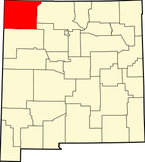
This is a list of the National Register of Historic Places listings in San Juan County, New Mexico.

National Register of Historic Places listings in Jasper County, South Carolina Wikimedia list article

This is a list of the National Register of Historic Places listings in Jasper County, South Carolina.

National Register of Historic Places listings in Knox County, Indiana

This is a list of the National Register of Historic Places listings in Knox County, Indiana.

National Register of Historic Places listings in Pike County, Ohio

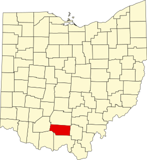
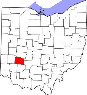
This is a list of the National Register of Historic Places listings in Pike County, Ohio.

References

  1. The latitude and longitude information provided in this table was derived originally from the National Register Information System, which has been found to be fairly accurate for about 99% of listings. Some locations in this table may have been corrected to current GPS standards.
  2. National Park Service, United States Department of the Interior, "National Register of Historic Places: Weekly List Actions", retrieved May 27, 2022.
  3. Numbers represent an alphabetical ordering by significant words. Various colorings, defined here, differentiate National Historic Landmarks and historic districts from other NRHP buildings, structures, sites or objects.
  4. The eight-digit number below each date is the number assigned to each location in the National Register Information System database, which can be viewed by clicking the number.
  5. Location derived from its GNIS feature record; the NRIS lists the site as "Address Restricted"
  6. Location derived from its GNIS entry; the NRIS lists it as "Address Restricted"