Signal Butte

Last updated

Signal Butte
Signal Butte NHL.jpg
Signal Butte
USA Nebraska location map.svg
Red pog.svg
Usa edcp location map.svg
Red pog.svg
Nearest city Gering, Nebraska
Coordinates 41°47′50″N103°54′24″W / 41.79722°N 103.90667°W / 41.79722; -103.90667
NRHP reference No. 66000452
Significant dates
Added to NRHPOctober 15, 1966 [1]
Designated NHLJanuary 20, 1961 [2]

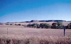
Signal Butte is a major prehistoric archaeological site in rural western Nebraska, United States. Designated by the Smithsonian trinomial 25SF1, it was one of the first pre-contact Native American sites to be formally investigated in the central plains. The archaeological sites are located atop the eponymous butte west of Robidoux Pass and Gering, Nebraska. It was declared a National Historic Landmark in 1961. [2] The site is not open to the public.

Contents

Description

The eponymous Signal Butte rises about 120 feet (37 m) above the plains in the watershed of the North Platte River in westernmost Nebraska. [3] The butte is covered by a layer of gravel and windblown soil, in which there are three distinct layers of cultural material. The oldest layers have been dated to 5,000 years ago, in the Middle Archaic Period. Finds at the site include stone projectile points and drills, and bone tools such as awls. [4]

The butte first came to the notice of professional archaeologists in 1931, when a local amateur notified William Duncan Strong of materials found there. Strong led investigations of the butte in 1931 and 1932, during which numerous artifacts were found, as well as features such as storage pits, fireplace hearths, and other signs of repeated habitation. [3] The site is one of the first from which a radiocarbon date was obtained, [4] although the exact dates of habitation have been the subject of some controversy and ongoing debate. [3] The site was investigated further in the 1940s and 1950s, at which time it was established that the sites probably represented seasonal hunting camps. [4]

See also

Related Research Articles

<span class="mw-page-title-main">National Register of Historic Places listings in Nebraska</span>

This is a list of more than 1,100 properties and districts in Nebraska that are on the National Register of Historic Places. Of these, 20 are National Historic Landmarks. There are listings in 90 of the state's 93 counties.

The Phipps Site (13CK21) is a Late Prehistoric Mill Creek culture archaeological site near Cherokee in Cherokee County, Iowa, United States. Its principal feature, a refuse midden, has yielded important information on the formation of middens in the region. The site was declared a National Historic Landmark in 1964.

<span class="mw-page-title-main">Ash Hollow State Historical Park</span> Park in Nebraska, USA

Ash Hollow State Historical Park is located five miles (8.0 km) south of Lewellen in Garden County, Nebraska. The park comprises two attractions located 2.5 miles (4.0 km) from each other: Ash Hollow Cave and Windlass Hill.

<span class="mw-page-title-main">Modoc Rock Shelter</span> Archaeological site in Illinois, United States

The Modoc Rock Shelter is a rock shelter or overhang located beneath the sandstone bluffs that form the eastern border of the Mississippi River floodplain at which Native American peoples lived for thousands of years. This site is significant for its archaeological evidence of thousands of years of human habitation during the Archaic period in the Eastern United States. It is located on the northeastern side of County Road 7 southeast of Prairie du Rocher in Randolph County, Illinois, United States. It was declared a National Historic Landmark in 1961.

<span class="mw-page-title-main">Clover site</span> Archaeological type site

The Clover site (46CB40) is a Fort Ancient culture archeological site located near Lesage in Cabell County, West Virginia, United States. It is significant for its well-preserved remains of a late prehistoric/protohistoric Native American village. The site's unique assemblage has made it the type site for the Clover Phase of the Madisonville horizon of the Fort Ancient culture.

<span class="mw-page-title-main">Amalik Bay Archeological District</span> Archaeological site in Alaska, United States

The Amalik Bay Archeological District is a geographic area with a significant number of archaeological sites in Alaska. It is located on the Pacific coast of Katmai National Park and Preserve, in the mainland portion of Kodiak Island Borough, Alaska.

<span class="mw-page-title-main">Borax Lake Site</span> Archaeological site in California, United States

The Borax Lake Site, also known as the Borax Lake—Hodges Archaeological Site and designated by the Smithsonian trinomial CA-LAK-36, is a prehistoric archaeological site near Clearlake, California. The site, a deeply stratified former lakeshore, contains evidence of the earliest known period of human habitation in what is now California, dating back 12,000 years. A portion of the site, designated a National Historic Landmark in 2006, is owned and preserved by the Archaeological Conservancy.

The McKean site is an archaeological site in Crook County, Wyoming, United States. A premier site of the Great Plains hunting cultures, it is the namesake of the "McKean Complex." Two significant contemporary sites of the same culture are Signal Butte in Nebraska and the LoDaisKa site in Colorado.

<span class="mw-page-title-main">Hardaway Site</span> United States historic place

The Hardaway Site, designated by the Smithsonian trinomial 31ST4, is an archaeological site near Badin, North Carolina. A National Historic Landmark, this multi-layered site has seen major periods of occupation as far back as 10,000 years. Materials from this site were and are used to assist in dating materials from other sites in the eastern United States. The site was declared a National Historic Landmark in 1990.

<span class="mw-page-title-main">Tobias-Thompson Complex</span> United States historic place

The Tobias-Thompson Complex, also known as the Little River Archeological District, is a complex of archaeological sites on the banks of the Little Arkansas River near Geneseo, Kansas, United States. The complex is an important set of sites that is one of the few in the region bridging the periods of prehistory and European contact, with a period of significance between 1500 and 1700 CE. It was designated a National Historic Landmark in 1964 and listed on the National Register of Historic Places in 1966.

<span class="mw-page-title-main">Palmer Site</span> United States historic place

The Palmer Site, also known as the Skidi Pawnee Village and designated by the Smithsonian trinomial 25HW1, is a prehistoric and historic archeological site near Palmer, Nebraska in Howard and Merrick Counties. The site is a Native American habitation site associated with the Skidi people, a branch of the Pawnee people, which may have been documented by an American exploratory expedition led by Stephen H. Long in 1820. It was declared a National Historic Landmark in 1964. The site is located on private property.

The Schultz site, also known as Mira Creek site, and designated by archaeologists with the Smithsonian trinomial 25 VY 1, is a major prehistoric archaeological site near North Loup, Nebraska. It is the largest Middle Woodland period site in the state, covering 30,000 square feet (2,800 m2), with layers suggestive of repeated occupation. It is one of the oldest sites in the state exhibiting evidence of pottery manufacture. It was declared a National Historic Landmark in 1964.

<span class="mw-page-title-main">Leary Site</span> Archaeological site in Nebraska, US

Leary Site, also known as 25-RH-1 or Leary-Kelly Site is an archaeological site near Rulo, Nebraska and the Big Nemaha River. The site now lies entirely on the reservation of the Iowa Tribe of Kansas and Nebraska. The area was once a village and burial site.

The Walker Gilmore site, designated by the Smithsonian trinomial 22CC28, is a prehistoric archaeological site near Murray, Nebraska. First formally investigated in 1915, it is the type site for the Sterns Creek focus, the first Woodland period culture identified in Nebraska. It was designated a National Historic Landmark in 1964.

The Lamoreau Site, also known as the Maine Archaeological Survey Site 23.13 is a Precontact Native American archaeological site in Auburn, Maine. It is located on the grounds of the Auburn/Lewiston Municipal Airport. The site was listed on the National Register of Historic Places in 1989. It is named for its discoverer, Henry Lamoreau.

<span class="mw-page-title-main">Fort Thompson Mounds</span> United States historic place

The Fort Thompson Mounds are a complex of ancient archaeological sites in Buffalo County, South Dakota, near Fort Thompson and within the Crow Creek Reservation. Declared a National Historic Landmark in 1964 by the US Department of Interior, the mound complex extends for a distance of about 6 miles (9.7 km) along the east bank of the Missouri River. It is one of the largest known complex of burial mounds in the Plains region north of Kansas.

Research Cave, also known as the Arnold Research Cave and the Saltpetre Cave, and designated by the Smithsonian trinomial 23CY64, is a major Native American archaeological site near Portland, Missouri. Investigation of the site has uncovered evidence of human habitation as far back as 8,000 years. The site was designated a National Historic Landmark in 1964; it has been recommended for de-designation due to looting.

<span class="mw-page-title-main">LoDaisKa site</span> Archaeological site in Colorado, United States

The LoDaisKa site is a prominent archaeological site in the U.S. state of Colorado, located within a rockshelter near Morrison. The rockshelter was first inhabited by people of the Archaic through the Middle Ceramic period, generally spanning 3000 BC to 1000 AD.

<span class="mw-page-title-main">Orwell Site (Orwell, Vermont)</span> United States historic place

The Orwell Site, designated VT-AD-12 in the state archaeological inventory, is a mainly prehistoric archaeological site in Orwell, Vermont. The site, first investigated in 1933, is significant as one of the state's few documented examples of a heavily stratified site, with layered evidence of occupation extending back at least 2,000 years, and into colonial times. It includes a prehistoric Native American burial site with at least 46 grave sites. It was listed on the National Register of Historic Places in 1977.

References

  1. "National Register Information System". National Register of Historic Places . National Park Service. January 23, 2007.
  2. 1 2 "Signal Butte". National Historic Landmark summary listing. National Park Service. Retrieved May 6, 2008.
  3. 1 2 3 "Signal Butte". National Park Service. Retrieved February 28, 2018.
  4. 1 2 3 "Behind the 2016 Poster – Signal Butte". Nebraska Archaeology. Retrieved February 28, 2018.