
The Great Plains are a broad expanse of flatland in North America. The region is located just to the east of the Rocky Mountains, much of it covered in prairie, steppe, and grassland. They are the western part of the Interior Plains, which include the mixed grass prairie, the tallgrass prairie between the Great Lakes and Appalachian Plateau, and the Taiga Plains and Boreal Plains ecozones in Northern Canada. "Great Plains" or Western Plains also describe the ecoregion of the Great Plains, or alternatively the western portion of the Great Plains.

Prairies are ecosystems considered part of the temperate grasslands, savannas, and shrublands biome by ecologists, based on similar temperate climates, moderate rainfall, and a composition of grasses, herbs, and shrubs, rather than trees, as the dominant vegetation type. Temperate grassland regions include the Pampas of Argentina, Brazil and Uruguay, and the steppe of Ukraine, Russia, and Kazakhstan. Lands typically referred to as "prairie" tend to be in North America. The term encompasses the area referred to as the Interior Lowlands of Canada, the United States, and Mexico, which includes all of the Great Plains as well as the wetter, hillier land to the east.

Sioux County is a county in the U.S. state of Nebraska. As of the 2020 United States Census, the population was 1,135. Its county seat is Harrison.

The Oglala National Grassland is a United States National Grassland in the northwest corner of Nebraska. It is in northern Sioux and northwestern Dawes counties, on the borders with South Dakota and Wyoming. It is 94,520 acres (38,250 ha) in size and is one of the small handful of National Grasslands administered by the US Department of Agriculture's Forest Service. It is managed by the U.S. Forest Service together with the Nebraska and Samuel R. McKelvie National Forests and the Buffalo Gap and Fort Pierre National Grasslands from common offices in Chadron, Nebraska.

The Plano cultures is a name given by archaeologists to a group of disparate hunter-gatherer communities that occupied the Great Plains area of North America during the Paleo-Indian or Archaic period.

The Pine Ridge is an escarpment between the Niobrara River and the White River in far northwestern Nebraska. The high tableland between the rivers has been eroded into a region of forested buttes, ridges and canyons.

The great bison belt is a tract of rich grassland that ran from Alaska to the Gulf of Mexico from around 9000 BC. The great bison belt was supported by spring and early summer rainfall that allowed short grasses to grow. These grasses retain their moisture at the roots which allowed for grazing ungulates such as bison to find high-quality nutritious food in autumn.
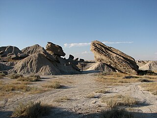
Toadstool Geologic Park is located in the Oglala National Grassland in far northwestern Nebraska. It is operated by the United States Forest Service. It contains a badlands landscape and a reconstructed sod house. The park is named after its unusual rock formations, many of which resemble toadstools.

Bison antiquus, the antique bison or ancient bison, is an extinct species of bison that lived in Late Pleistocene North America until around 10,000 years ago. Bison antiquus was one of the most common large herbivores in Late Pleistocene North America. It is a direct ancestor of the living American bison.
Herschel is a special service area in the Canadian province of Saskatchewan. It is the seat of the Rural Municipality of Mountain View No. 318 and held village status prior to December 31, 2006. The population was 30 people in 2016. The community is located 37 km northwest of the town of Rosetown at the intersection of Highway 31 and Highway 656, along a now abandoned section of the Kerrobert-Rosetown Canadian Pacific Railway line. Herschel is the home of the Ancient Echoes Interpretive Centre. The Vancouver-based backpack manufacturer Herschel Supply Co., founded by Lyndon and Jamie Cormack in 2009, adopted the name of Herschel, the town where three generations of their family grew up.

This is a list of the National Register of Historic Places listings in Larimer County, Colorado.
Joe Ben Wheat (1916–1997) was an American archaeologist, curator, teacher, and author known for his expertise on woven textiles produced by the Navajo and other Native American tribes in Arizona, New Mexico, and Colorado. His research also focused on Mogollon, Anasazi, Great Plains Paleo-Indian, and African Paleolithic archaeology.
Prehistory of Colorado provides an overview of the activities that occurred prior to Colorado's recorded history. Colorado experienced cataclysmic geological events over billions of years, which shaped the land and resulted in diverse ecosystems. The ecosystems included several ice ages, tropical oceans, and a massive volcanic eruption. Then, ancient layers of earth rose to become the Rocky Mountains.

The Purgatoire River track site, also called the Picketwire Canyonlands tracksite, is one of the largest dinosaur tracksites in North America. The site is located on public land of the Comanche National Grassland, along the Purgatoire ("Picketwire") River south of La Junta in Otero County, Colorado.

The ecology of the Rocky Mountains is diverse due to the effects of a variety of environmental factors. The Rocky Mountains are the major mountain range in western North America, running from the far north of British Columbia in Canada to New Mexico in the southwestern United States, climbing from the Great Plains at or below 1,800 feet (550 m) to peaks of over 14,000 feet (4,300 m). Temperature and rainfall varies greatly also and thus the Rockies are home to a mixture of habitats including the alpine, subalpine and boreal habitats of the Northern Rocky Mountains in British Columbia and Alberta, the coniferous forests of Montana and Idaho, the wetlands and prairie where the Rockies meet the plains, a different mix of conifers on the Yellowstone Plateau in Wyoming, the montane forests of Utah, and in the high Rockies of Colorado and New Mexico, and finally the alpine tundra of the highest elevations.
The Olsen–Chubbuck Bison kill site is a Paleo-Indian site that dates to an estimated 8000–6500 B.C. and provides evidence for bison hunting and using a game drive system, long before the use of the bow and arrow or horses. The site holds a bone bed of nearly 200 bison that were killed, butchered, and consumed by Paleo-Indian hunters. The site is located 16 miles southeast of Kit Carson, Colorado. The site was named after archaeologists, Sigurd Olsen and Gerald Chubbuck, who discovered the bone bed in 1957. In 1958, the excavation of the Olsen-Chubbuck site was then turned over to the University of Colorado Museum of Natural History, a team led by Joe Ben Wheat, an anthropologist employed by the museum.

The Hilda mega-bonebed is a complex of fourteen probable Centrosaurus apertus bonebeds discovered near the town of Hilda in Alberta, Canada. It was first described in the scientific literature by David Eberth, Donald Brinkman, and Vaia Barkas in 2010 after more than ten years of research. The Hilda mega-bonebed is significant because the behavior of the preserved dinosaurs themselves was the dominant cause of its existence, rather than the stratum's geological history like most bonebeds. It is also Canada's largest bonebed.
Paleontology in Colorado refers to paleontological research occurring within or conducted by people from the U.S. state of Colorado. The geologic column of Colorado spans about one third of Earth's history. Fossils can be found almost everywhere in the state but are not evenly distributed among all the ages of the state's rocks. During the early Paleozoic, Colorado was covered by a warm shallow sea that would come to be home to creatures like brachiopods, conodonts, ostracoderms, sharks and trilobites. This sea withdrew from the state between the Silurian and early Devonian leaving a gap in the local rock record. It returned during the Carboniferous. Areas of the state not submerged were richly vegetated and inhabited by amphibians that left behind footprints that would later fossilize. During the Permian, the sea withdrew and alluvial fans and sand dunes spread across the state. Many trace fossils are known from these deposits.
Hell Gap is a deeply stratified archaeological site located in the Great Plains of eastern Wyoming, approximately thirteen miles north of Guernsey, where an abundant amount of Paleoindian and Archaic artifacts have been found and excavated since 1959. This site has had an important impact on North American archaeology because of the large quantity and breadth of prehistoric Paleoindian and Archaic period artifacts and cultures it encompasses. It was designated a National Historic Landmark in 2016.
Bechan Cave is a single-room sandstone rock shelter located at an elevation of 1,280 metres (4,200 ft) along Bowns Canyon Creek, a tributary of the Glen Canyon segment of the Colorado River, in Kane County in southeastern Utah in the United States. The cave is roughly 31 metres (100 ft) wide, 9 metres (30 ft) high and 52 metres (170 ft) deep. It has a single entrance that faces southwest and is well-lit during the daytime.


