Winnebago Reservation

Last updated
Winnebago Reservation
Flag of the Winnebago Tribe of Nebraska.PNG
4625R Winnebago Reservation Locator Map.svg
Location of the Winnebago Reservation in Nebraska
Usa edcp relief location map.png
Red pog.svg
Winnebago Reservation
Location in the United States
Coordinates: 42°13′28″N96°35′49″W / 42.22444°N 96.59694°W / 42.22444; -96.59694
Tribe Winnebago
Country United States
State Nebraska and Iowa
County Thurston County, Nebraska, Dixon County, Nebraska and Woodbury County, Iowa
Headquarters Winnebago, Nebraska
Area
[1]
  Total177.66 sq mi (460.1 km2)
  Land176.55 sq mi (457.3 km2)
  Water1.11 sq mi (2.9 km2)
Population
 (2020) [2]
  Total2,737
  Density15.5/sq mi (6.0/km2)
Website Winnebago Tribe of Nebraska

The Winnebago Reservation of the Winnebago Tribe of Nebraska is located in the U.S. in Thurston County, Nebraska, United States. The tribal council offices are located in the town of Winnebago. [3] The villages of Emerson, south of First Street, as well as Thurston, are also located on the reservation. The reservation occupies northern Thurston County, Nebraska, as well as southeastern Dixon County and Woodbury County, Iowa, and a small plot of off-reservation land of southern Craig Township in Burt County, Nebraska. The other federally recognized Winnebago tribe is the Ho-Chunk Nation of Wisconsin.

Contents

Early history

The Winnebago Reservation is on land that originally belonged to the Omaha Nation. On February 21, 1863, Congress passed legislation removing the Winnebago, who call themselves the Ho-Chunk, from a reservation in Blue Earth County, Minnesota to Crow Creek, South Dakota. [4] This location lacked essential resources, leading to a famine that sent many Winnebago people to seek refuge on the Omaha Reservation further down the Missouri River. [5] In order to establish a separate Winnebago Reservation, the Omaha Nation ceded the northern portion of their own reservation to the United States on March 6, 1865, [6] and the United States granted this area to the Winnebago Tribe in exchange for their South Dakota lands in a treaty on March 8, 1865. [7] The Omaha Nation later conveyed an additional 12,348 acres (49.97 km2) of timber land to the Winnebago Reservation through an act of Congress on June 22, 1874 and a deed dated July 31, 1874. [8]

Federal legislation including the Dawes Act of 1887 led to the allotment of Winnebago tribal lands into private ownership. By 1910, the Bureau of Indian Affairs reported that 106,040.82 acres (429.1320 km2) were allotted to 1,200 Indians; 480 acres (1.9 km2) reserved for agency, etc.; the residue, 1,710.80 acres (6.9234 km2), is unallotted. [9]

Geography

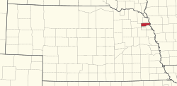
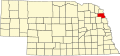
According to the United States Census Bureau, the reservation has a total area of 177.66 square miles (460.1 km2), of which 176.55 square miles (457.3 km2) is land and 1.11 square miles (2.9 km2) is water. The Winnebago Tribe of Nebraska held an additional 0.179 square miles (115 acres; 0.46 km2) of off-reservation trust land as of 2020. [1]

Due to allotment under the Dawes Act of 1887, much of the reservation is no-longer tribally-owned. [10] According to the Bureau of Indian Affairs, the tribe's total trust land was 27,637 acres (43.183 sq mi; 111.84 km2), or about 24.5% of the reservation land area. [11]

Demographics

As of the census of 2020, [2] the population living within the reservation boundaries was 2,737. The population density was 15.5 inhabitants per square mile (6.0/km2). There were 921 housing units at an average density of 5.2 per square mile (2.0/km2). The racial makeup of the reservation and off-reservation trust land was 67.1% Native American, 26.9% White, 0.7% Black or African American, 0.2% Pacific Islander, 0.2% Asian, 0.8% from other races, and 4.2% from two or more races. Ethnically, the population was 4.2% Hispanic or Latino of any race.

Economic development

Ho-Chunk Village Statue Garden, Winnebago, NE Ho-Chunk Village Statue Garden.jpg
Ho-Chunk Village Statue Garden, Winnebago, NE

In 1992 the federally recognized tribe established the WinnaVegas Casino to generate revenues and provide employment. Its council had already legalized alcohol sales on the reservation, in order to keep the revenues from sales taxes and associated fees that its residents had previously paid through off-reservation merchants to the state. It also now directly regulates the sales and can provide for treatment for individuals and families affected by alcoholism. As of 2007, 63% of federally recognized tribes in the lower 48 states had legalized alcohol sales for similar reasons. [12]

In 1994, based on a long-term view of growth, the tribe founded Ho-Chunk, Inc., its economic development corporation, which has strongly contributed to new resources on the reservation. Beginning with one employee, it has grown to 1400 employees operating in 10 states and five foreign countries. Its revenues have provided for development in 1995 of Little Priest Tribal College; as well as a new community school, hospital and a strong housing construction program of more than $1 million, with development of Ho-Chunk Village. [13]

The rise in its economy has enabled the tribe to improve the quality of life on the reservation, as Lance Morgan, the CEO of the corporation, discussed in a forum at Bellevue University in Omaha, Nebraska, on April 2, 2010. [14] Ho-Chunk, Inc. has gained awards for small business, and it has initiated a strong housing construction program in collaboration with federal programs. Its leaders were featured on Native American Entrepreneurs, airing in 2009 on PBS. [15] Ho-Chunk, Inc. operates 26 subsidiaries in areas such as information technology, construction, government contracting, green energy, retail, wholesale distribution, marketing, media and transportation.

See also

Notes

  1. 1 2 "2020 Gazetteer Files". census.gov. U.S. Census Bureau. Retrieved 18 July 2022.
  2. 1 2 "2020 Decennial Census: Winnebago Reservation and Off-Reservation Trust Land, NE--IA". data.census.gov. U.S. Census Bureau. Retrieved 18 July 2022.
  3. "Winnebago Tribe", Nebraska Indian Commission. Retrieved 6/28/08.
  4. Lass, William E. (1963). "The Removal from Minnesota of the Sioux and Winnebago Indians". Minnesota History. 38 (8): 353–364. ISSN   0026-5497. JSTOR   20176531 . Retrieved 2022-07-19.
  5. Wishart 1994, pp. 159–160.
  6. "Treaty with the Omaha, 1865". Tribal Treaties Database. Oklahoma State University. Retrieved 19 July 2022.
  7. "Treaty with the Winnebago, 1865". Tribal Treaties Database. Oklahoma State University. Retrieved 19 July 2022.
  8. Wishart 1994, pp. 233–234.
  9. Report of the Commissioner of Indian Affairs. Washington: U.S. Government Printing Office. 1909. p. 132.
  10. "Tribal History". www.winnebagotribe.com. Winnebago Tribe of Nebraska. Retrieved 18 July 2022.
  11. "Winnebago Agency". www.bia.gov. Bureau of Indian Affairs. Retrieved 18 July 2022.
  12. James N. Hughes III, "Pine Ridge, Whiteclay and Indian Liquor Law", Federal Indian Law Seminar, December 2010, p. 7, University of Nebraska College of Law, accessed 27 February 2012
  13. Ho-Chunk, Inc., Website, accessed 1 March 2012
  14. KEVIN ABOUREZK, "Winnebago business leader: Poverty at heart of Whiteclay debacle", Lincoln Journal Star, 7 April 2010, accessed 29 February 2012
  15. Native American Entrepreneurs, American Experience, PBS; 13, 20, and 27 April 2009, accessed 1 March 2012

Related Research Articles

<span class="mw-page-title-main">Thurston County, Nebraska</span> County in Nebraska, United States

Thurston County is a county in the U.S. state of Nebraska. As of the 2020 United States Census, the population was 6,773. Its county seat is Pender.

<span class="mw-page-title-main">Pender, Nebraska</span> Village in and county seat of Thurston County, Nebraska, United States

Pender is a village in and the county seat of Thurston County, Nebraska, United States. On March 22, 2016, the United States Supreme Court resolved a disagreement as to whether Pender is located on the Omaha Indian Reservation, holding unanimously that "the disputed land is within the reservation’s boundaries." The predominantly European-American population was 1,115 at the 2020 census.

<span class="mw-page-title-main">Winnebago, Nebraska</span> Village in Thurston County, Nebraska, United States

Winnebago is a village in Thurston County, Nebraska, United States. The population was 916 at the 2020 census.

<span class="mw-page-title-main">Pine Ridge Indian Reservation</span> Indian reservation in United States, Oglala Sioux

The Pine Ridge Indian Reservation, also called Pine Ridge Agency, is an Oglala Lakota Indian reservation located in the U.S. state of South Dakota, with a small portion of it extending into Nebraska. Originally included within the territory of the Great Sioux Reservation, Pine Ridge was created by the Act of March 2, 1889, 25 Stat. 888. in the southwest corner of South Dakota on the Nebraska border. It consists of 3,468.85 sq mi (8,984 km2) of land area and is one of the largest reservations in the United States.

<span class="mw-page-title-main">Whiteclay, Nebraska</span> Census-designated place in Nebraska, United States

Whiteclay is a census-designated place in Sheridan County, Nebraska, United States. The population was 10 at the 2010 census.

<span class="mw-page-title-main">Ho-Chunk</span> Siouan-speaking Native American people

The Ho-Chunk, also known as Hocąk, Hoocągra, or Winnebago, are a Siouan-speaking Native American people whose historic territory includes parts of Wisconsin, Minnesota, Iowa, and Illinois. Today, Ho-Chunk people are enrolled in two federally recognized tribes, the Ho-Chunk Nation of Wisconsin and the Winnebago Tribe of Nebraska.

<span class="mw-page-title-main">L'Anse Indian Reservation</span> Indian reservation in Michigan, United States

The L'Anse Indian Reservation is the land base of the federally recognized Keweenaw Bay Indian Community of the historic Lake Superior Band of Chippewa Indians.. The reservation is located primarily in two non-contiguous sections on either side of the Keweenaw Bay in Baraga County in the Upper Peninsula of the U.S. state of Michigan. The Keweenaw Bay Community also manages the separate Ontonagon Indian Reservation.

<span class="mw-page-title-main">Menominee</span> Federally-recognized indigenous people of the United States

The Menominee are a federally recognized tribe of Native Americans officially known as the Menominee Indian Tribe of Wisconsin. Their land base is the Menominee Indian Reservation in Wisconsin. Their historic territory originally included an estimated 10 million acres (40,000 km2) in present-day Wisconsin and the Upper Peninsula of Michigan. The tribe currently has about 8,700 members.

<span class="mw-page-title-main">Lower Sioux Indian Reservation</span> Mdewakanton and Wahpekute bands of the Lower Sioux

The Lower Sioux Indian Community, also known as the Mdewakanton Tribal Reservation, is an Indian reservation located along the southern bank of the Minnesota River in Paxton and Sherman townships in Redwood County, Minnesota. Its administrative headquarters is two miles south of Morton. The reservation is located southeast of Redwood Falls, the county seat.

<span class="mw-page-title-main">Shakopee Mdewakanton Sioux Community</span> Indian tribe community in Scott County, Minnesota, United States

The Shakopee Mdewakanton Sioux Community is a federally recognized, sovereign Indian tribe of Mdewakanton Dakota people, located southwest of Minneapolis and Saint Paul, within parts of the cities of Prior Lake and Shakopee in Scott County, Minnesota. Mdewakanton, pronounced Mid-ah-wah-kah-ton, means "dwellers at the spirit waters."

<span class="mw-page-title-main">Upper Sioux Indian Reservation</span> In Minnesota Falls Township along the Minnesota River

The Upper Sioux Indian Reservation, or Pezihutazizi in Dakota, is the reservation of the Upper Sioux Community, a federally recognized tribe of the Dakota people, that includes the Mdewakanton.

<span class="mw-page-title-main">Crow Creek Indian Reservation</span> Indian reservation in South Dakota, United States

The Crow Creek Indian Reservation, home to Crow Creek Sioux Tribe is located in parts of Buffalo, Hughes, and Hyde counties on the east bank of the Missouri River in central South Dakota in the United States. It has a land area of 421.658 square miles (1,092.09 km2) and a 2000 census population of 2,225 persons. The major town and capital of the federally recognized Crow Creek Sioux Tribe is Fort Thompson.

<span class="mw-page-title-main">Ho-Chunk Nation of Wisconsin</span> Ethnic group

The Ho-Chunk Nation is a federally recognized tribe of the Ho-Chunk with traditional territory across five states in the United States: Wisconsin, Illinois, Iowa, Minnesota, and Missouri. The other federally recognized tribe of Ho-Chunk people is the Winnebago Tribe of Nebraska. The tribe separated when its members were forcibly relocated first to an eastern part of Iowa known as the Neutral Ground, then to Minnesota, South Dakota and later to the current reservation in Nebraska.

<span class="mw-page-title-main">Winnebago Tribe of Nebraska</span> Native American tribe

The Winnebago Tribe of Nebraska is one of two federally recognized tribes of Ho-Chunk Native Americans. The other is the Ho-Chunk Nation of Wisconsin. Tribe members often refer to themselves as Hochungra – "People of the Parent Speech". Their language is part of the Siouan family.

A Half-Breed Tract was a segment of land designated in the western states by the United States government in the 19th century specifically for Métis of American Indian and European or European-American ancestry, at the time commonly known as half-breeds. The government set aside such tracts in several parts of the Midwestern prairie region, including in Iowa Territory, Nebraska Territory, Kansas Territory, Minnesota Territory, and Wisconsin Territory.

<span class="mw-page-title-main">Native American tribes in Nebraska</span>

Native American tribes in the U.S. state of Nebraska have been Plains Indians, descendants of succeeding cultures of indigenous peoples who have occupied the area for thousands of years. More than 15 historic tribes have been identified as having lived in, hunted in, or otherwise occupied territory within the current state boundaries.

<span class="mw-page-title-main">Omaha Reservation</span> Indian reservation in Nebraska and Iowa, US

The Omaha Reservation of the federally recognized Omaha tribe is located mostly in Thurston County, Nebraska, with sections in neighboring Cuming and Burt counties, in addition to Monona County in Iowa. As of the 2020 federal census, the reservation population was 4,526. The tribal seat of government is in Macy. The villages of Rosalie, Pender and Walthill are located within reservation boundaries, as is the northernmost part of Bancroft. Due to land sales in the area since the reservation was established, Pender has disputed tribal jurisdiction over it, to which the Supreme Court ruled unanimously in 2016 that "the disputed land is within the reservation’s boundaries."

The Ponca Reservation of the Ponca Tribe of Nebraska is located in northeast Nebraska, with the seat of tribal government located in Niobrara, Knox County. The Indian reservation is also the location of the historic Ponca Fort called Nanza. The Ponca tribe does not actually have a reservation because the state of Nebraska will not allow them to have one. However, they do in fact have a 15-county service delivery area, including counties spread throughout Nebraska, South Dakota and Iowa.

<span class="mw-page-title-main">Meskwaki Settlement, Iowa</span> Meskwakiinaki, an Indian settlement in Iowa

Meskwakiinaki, also called the Meskwaki Settlement, is an unincorporated community in Tama County, Iowa, United States, west of Tama. It encompasses the lands of the Meskwaki Nation, one of three Sac and Fox tribes in the United States. The others are located in Oklahoma and Kansas. The settlement is located in the historic territory of the Meskwaki (Fox), an Algonquian people. Meskwaki people established the settlement in 1857 by privately repurchasing a small part of the land they had lost in the Sac and Fox treaty of 1842.

Franklin Dean LaMere was an American activist and politician. He was a member of the Winnebago Tribe of Nebraska from South Sioux City, and the son of a Gold Star Mother and a combat veteran father. He was a member of the American Indian Movement (AIM) in the 1970s and was noted for his work opposing liquor sales in Whiteclay, Nebraska, a small town whose main industry is selling alcohol to residents of the nearby Pine Ridge Indian Reservation, where alcohol sales are prohibited. LaMere was a leader in the Democratic Party, and served as chairman of the National Native American Caucus. He was a delegate to the Democratic National Convention seven consecutive times from 1988 to 2012.

References