Pender Township | |
|---|---|
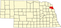
 Location in Thurston County | |
| Coordinates: 42°07′59″N096°41′10″W / 42.13306°N 96.68611°W | |
| Country | United States |
| State | Nebraska |
| County | Thurston |
| Area | |
• Total | 30.16 sq mi (78.11 km2) |
| • Land | 30.14 sq mi (78.07 km2) |
| • Water | 0.02 sq mi (0.04 km2) 0.05% |
| Elevation | 1,375 ft (419 m) |
| Population | |
• Total | 1,242 |
| • Density | 41/sq mi (16/km2) |
| ZIP code | 68047 [2] |
| Area codes | 402 and 531 |
| GNIS feature ID | 0838184 [3] |
Pender Township is one of eleven townships in Thurston County, Nebraska, United States. [3] The population was 1,242 at the 2020 census. [1]
Contents
The village of Pender lies within the southwestern part of township. Nebraska Highway 9 and Nebraska Highway 16 both pass through the township, and Nebraska Highway 94 has its western terminus in the village of Pender. Logan Creek (also known as Logan Creek Dredge) also runs through the township. [4]